Tiedosto:Tirol 1918.png
Tämän esikatselun koko: 796 × 600 kuvapistettä. Muut resoluutiot: 319 × 240 kuvapistettä | 637 × 480 kuvapistettä | 1 019 × 768 kuvapistettä | 1 280 × 965 kuvapistettä | 1 502 × 1 132 kuvapistettä.
Alkuperäinen tiedosto (1 502 × 1 132 kuvapistettä, 193 KiB, MIME-tyyppi: image/png)
| Tämä tiedosto on tiedostotietokanta Wikimedia Commonsista. Tiedot kuvaussivulta näkyvät alla. |  |
Tiedoston kuvaussivu Commonsissa |
Yhteenveto
| Kuvaus |
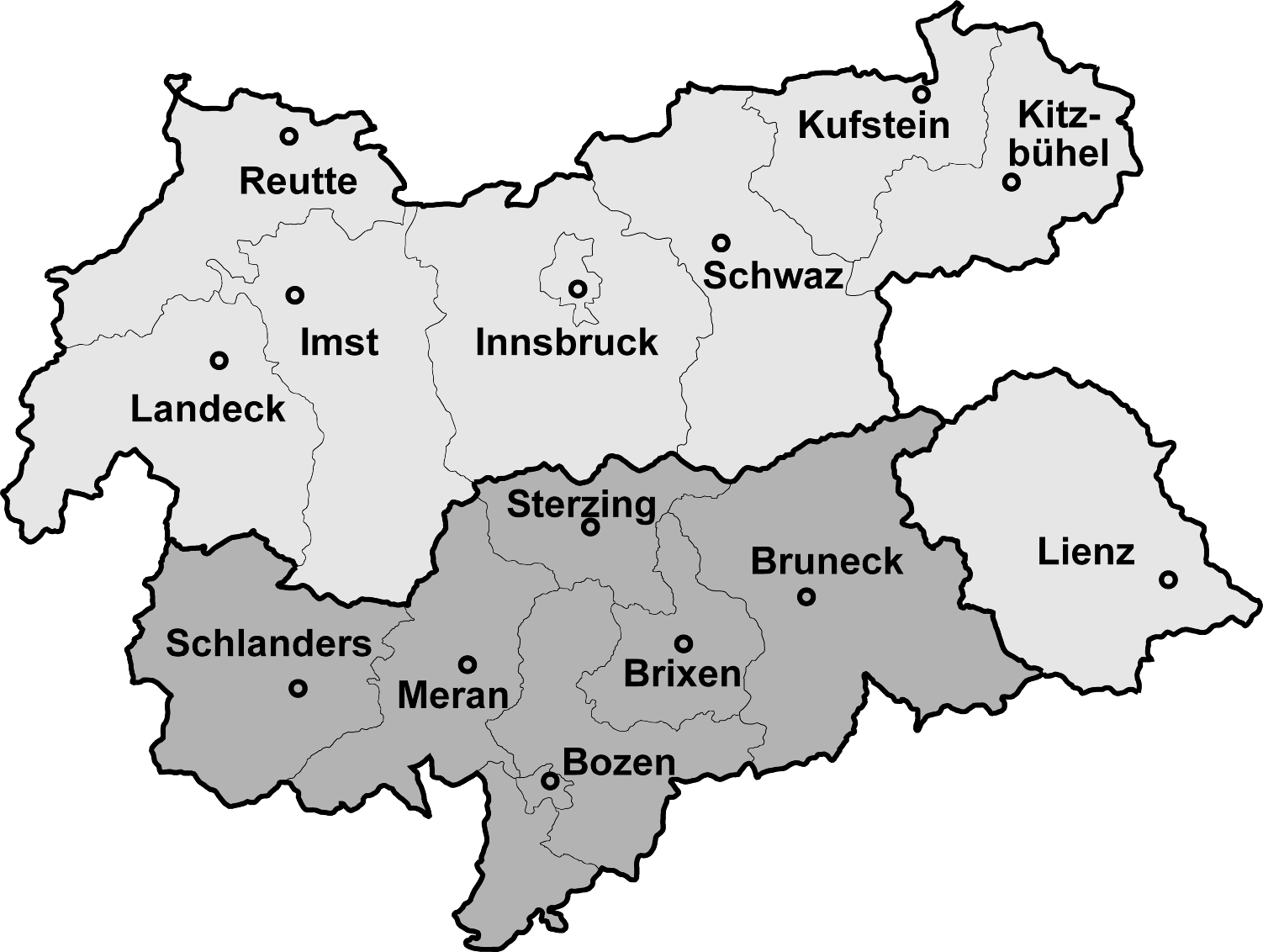
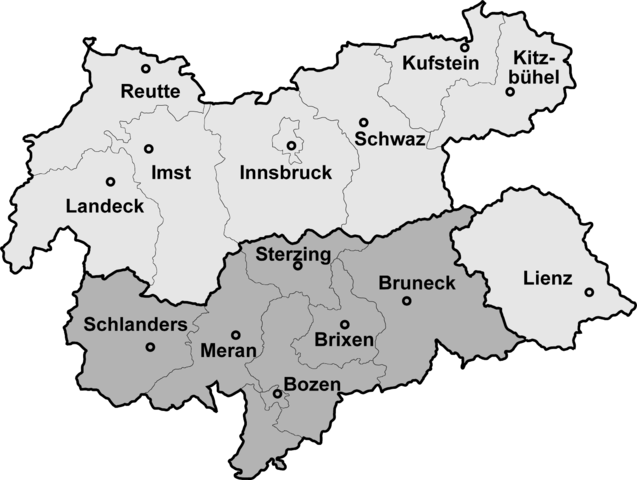
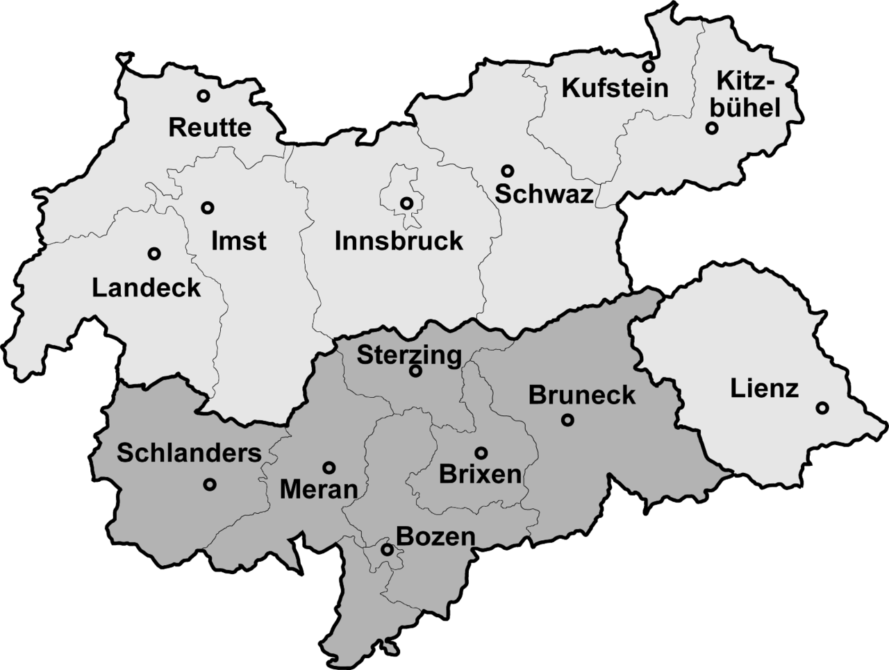
Map of North, South and Eastern Tirol with district borders Deutsch: Isolierte Lage des Bezirks Lienz (Osttirol) nach der Abtrennung Südtirols (dunkelgrau) 1918
English: Tyrol after 1918, the southern part is now a part of Italy
Português: Mapa do Tirol com a divisão de 1918 que o dividiu entre Áustria (parte setentrional) e Itália (parte meridional) |
|||
| Päiväys | 4. helmikuuta 2006 (tallennuspäivä) | |||
| Lähde | Map drawn by (Geiserich77) | |||
| Tekijä | Geiserich77 | |||
| Muut versiot |
|


|
Voit kopioida, levittää ja/tai muuttaa tätä asiakirjaa GNU Free Documentation License -lisenssin version 1.2 tai minkä tahansa Free Software Foundationin julkaiseman myöhemmän version ehtojen alaisena; ei koske muuttumattomia kohtia, etukannen tekstejä eikä takakannen tekstejä. Kopio tästä lisenssistä on saatavilla osiossa GNU Free Documentation License. |
| Tämä tiedosto on lisensoitu Creative Commons Nimeä-JaaSamoin 3.0 Ei sovitettu -lisenssillä. | ||
| ||
| Lisensointimerkintä lisätiin tähän tiedostoon osana GFDL-lisensointipäivitystä. |
Tiedoston historia
Päiväystä napsauttamalla näet, millainen tiedosto oli kyseisellä hetkellä.
| Päiväys | Pienoiskuva | Koko | Käyttäjä | Kommentti | |
|---|---|---|---|---|---|
| nykyinen | 4. helmikuuta 2006 kello 15.10 | | 1 502 × 1 132 (193 KiB) | Geiserich77 | == Beschreibung == {{Information| |Description = Map of North, South and Eastern Tirol with district borders |Source = Map drawn by (Geiserich77) |Date = 29.01.2006 |Author = Geiserich77 |Permission = GNU FDL |oth |
| 29. tammikuuta 2006 kello 16.49 |  | 1 598 × 1 248 (197 KiB) | Geiserich77 | {{Information| |Description = Map of North, South and Eastern Tirol with district borders |Source = Map drawn by (Geiserich77) |Date = 29.01.2006 |Author = Geiserich77 |Permission = GNU FDL |other_versions = - }} |
Tiedoston käyttö
Seuraavat 2 sivua käyttävät tätä tiedostoa:
Tiedoston järjestelmänlaajuinen käyttö
Seuraavat muut wikit käyttävät tätä tiedostoa:
- Käyttö kohteessa an.wikipedia.org
- Käyttö kohteessa ast.wikipedia.org
- Käyttö kohteessa br.wikipedia.org
- Käyttö kohteessa cs.wikipedia.org
- Käyttö kohteessa eo.wikipedia.org
- Käyttö kohteessa es.wikipedia.org
- Käyttö kohteessa hu.wikipedia.org
- Käyttö kohteessa is.wikipedia.org
- Käyttö kohteessa ja.wikipedia.org
- Käyttö kohteessa lmo.wikipedia.org
- Käyttö kohteessa nds-nl.wikipedia.org
- Käyttö kohteessa nl.wikipedia.org