Tiedosto:Map of The Hotakids.png
Tarkempaa kuvaa ei ole saatavilla.
Map_of_The_Hotakids.png (620 × 429 kuvapistettä, 27 KiB, MIME-tyyppi: image/png)
| Tämä tiedosto on tiedostotietokanta Wikimedia Commonsista. Tiedot kuvaussivulta näkyvät alla. |  |
Tiedoston kuvaussivu Commonsissa |
Yhteenveto
| Kuvaus |
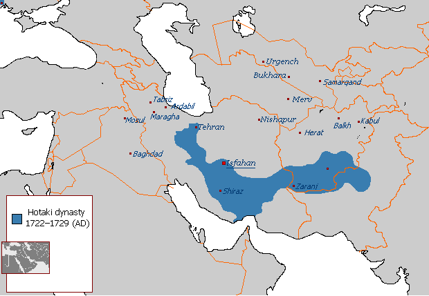
English: Map of The Hotakids from 1722 to 1729 |
| Päiväys | 29. elokuuta 2007 (alkuperäinen tallennuspäivä) |
| Lähde |
Oma teos, Sources consulted in the making of this map include: The Fall of the Safavi Dynasty and the Afghan Occupation of Persia by Laurence Lockhart The Afghan Occupation of Safavid Persia 1721-1729 by Willem Floor Articles from Encyclopedia Iranica History of the Wars 1721-1738 by Abraham of Erevan and translated by George A. Bournoutian The Chronicles of a Traveller: Or, A History of the Afghan Wars with Persia by Tadeusz Judas Krusiński |
| Tekijä | Arab Hafez projektissa Wikipedia kielellä englanti |
Lisenssi
| Tämän teoksen tekijä, Arab Hafez projektissa Wikipedia kielellä englanti, on julkaissut sen public domainiin. Tämä on voimassa maailmanlaajuisesti. Joissain maissa laki ei mahdollista tätä. Mikäli näin on: Arab Hafez myöntää kaikille oikeuden käyttää tätä teosta mihin tahansa tarkoitukseen ilman minkäänlaisia ehtoja, ellei laki vaadi ehtojen asettamista. |
Alkuperäinen tallennusloki
Siirretty projektista en.wikipedia Commonsiin.
Alkuperäinen kuvaussivu oli täällä. Käyttäjätunnukset alla viittaavat kohteeseen en.wikipedia.
- 2007-08-29 21:49 Arab Hafez 620×429× (24487 bytes)
Tiedoston historia
Päiväystä napsauttamalla näet, millainen tiedosto oli kyseisellä hetkellä.
| Päiväys | Pienoiskuva | Koko | Käyttäjä | Kommentti | |
|---|---|---|---|---|---|
| nykyinen | 17. elokuuta 2021 kello 16.42 | | 620 × 429 (27 KiB) | Kailanmapper | Reverted to version as of 16:37, 31 July 2021 (UTC) if you would read the sources you would know its accurate |
| 16. elokuuta 2021 kello 00.20 |  | 620 × 429 (18 KiB) | Casperti | Reverted to version as of 12:38, 31 July 2021 (UTC) Do not engage in a conflict on Wiki commons open a discussion where you get consensus for it | |
| 31. heinäkuuta 2021 kello 19.37 |  | 620 × 429 (27 KiB) | Noorullah21 | Reverted to version as of 12:51, 28 July 2021 (UTC) Final edit before this traerses to an edit war, first of all, the ottoman hotak war ended 1-2 years prior to this map, this map is a 1728-1729 hotak map. 2. The old map is incredibly inaccurate, and exaggerated claims throughout, it is unsourced and a wrong map. Hence why it is being replaced with the one Kalilan made, a much more accurate map. | |
| 31. heinäkuuta 2021 kello 15.38 |  | 620 × 429 (18 KiB) | Casperti | Reverted to version as of 10:58, 28 July 2021 (UTC) Against all reliable sources and consensus. Besides the Ottoman-Hotak war Is here ignored | |
| 28. heinäkuuta 2021 kello 15.51 |  | 620 × 429 (27 KiB) | Kailanmapper | Reverted to version as of 03:16, 28 July 2021 (UTC) the ip addresses involved haven't even tried to address my claims after several days. Plus Wikipedia literally says that unsourced information should be challenged and removed. I initially uploaded my own work separately but it got removed countless times from those very ip adresses who are refusing to say anything | |
| 28. heinäkuuta 2021 kello 13.58 |  | 620 × 429 (18 KiB) | Xerxes1985 | Reverted to version as of 02:20, 28 July 2021 (UTC)inaccurate or accurate doesn’t matter, Again, where’s your consensus for this version? Upload your own work separately if you want to | |
| 28. heinäkuuta 2021 kello 06.16 |  | 620 × 429 (27 KiB) | Kailanmapper | Reverted to version as of 20:53, 27 July 2021 (UTC) again, that is inaccurate and unsourced | |
| 28. heinäkuuta 2021 kello 05.20 |  | 620 × 429 (18 KiB) | Xerxes1985 | Reverted to version as of 11:10, 27 July 2021 (UTC) No consensus for this map | |
| 27. heinäkuuta 2021 kello 23.53 |  | 620 × 429 (27 KiB) | Noorullah21 | The old map is inaccurate, read the talk page please. | |
| 27. heinäkuuta 2021 kello 14.10 |  | 620 × 429 (18 KiB) | Mukhis125 | Reverted to version as of 08:28, 19 August 2011 (UTC) |
Tiedoston käyttö
Seuraava sivu käyttää tätä tiedostoa:
Tiedoston järjestelmänlaajuinen käyttö
Seuraavat muut wikit käyttävät tätä tiedostoa:
- Käyttö kohteessa ar.wikipedia.org
- Käyttö kohteessa ast.wikipedia.org
- Käyttö kohteessa bn.wikipedia.org
- Käyttö kohteessa en.wikipedia.org
- Käyttö kohteessa eo.wikipedia.org
- Käyttö kohteessa et.wikipedia.org
- Käyttö kohteessa fa.wikipedia.org
- Käyttö kohteessa he.wikipedia.org
- Käyttö kohteessa hr.wikipedia.org
- Käyttö kohteessa id.wikipedia.org
- Käyttö kohteessa it.wikipedia.org
- Käyttö kohteessa nl.wikipedia.org
- Käyttö kohteessa no.wikipedia.org
- Käyttö kohteessa pnb.wikipedia.org
- Käyttö kohteessa ps.wikipedia.org
- Käyttö kohteessa pt.wikipedia.org
- Käyttö kohteessa ru.wikipedia.org
- Käyttö kohteessa sh.wikipedia.org
- Käyttö kohteessa sv.wikipedia.org
- Käyttö kohteessa tg.wikipedia.org
- Käyttö kohteessa tr.wikipedia.org
- Käyttö kohteessa uk.wikipedia.org
- Käyttö kohteessa www.wikidata.org
- Käyttö kohteessa zh.wikipedia.org