Tiedosto:ScotlandMoray.png
Tämän esikatselun koko: 480 × 599 kuvapistettä. Muut resoluutiot: 192 × 240 kuvapistettä | 384 × 480 kuvapistettä | 615 × 768 kuvapistettä | 820 × 1 024 kuvapistettä | 1 641 × 2 048 kuvapistettä | 2 733 × 3 411 kuvapistettä.
Alkuperäinen tiedosto (2 733 × 3 411 kuvapistettä, 216 KiB, MIME-tyyppi: image/png)
| Tämä tiedosto on tiedostotietokanta Wikimedia Commonsista. Tiedot kuvaussivulta näkyvät alla. |  |
Tiedoston kuvaussivu Commonsissa |

|
Tästä tiedostosta on saatavilla myös SVG-versio eli vektorigrafiikkatiedosto. SVG-versiota tulisi suosia, mikäli se on laadultaan tätä rasterikuvaa parempi.
File:ScotlandMoray.png → File:ScotlandMoray.svg
|
 |
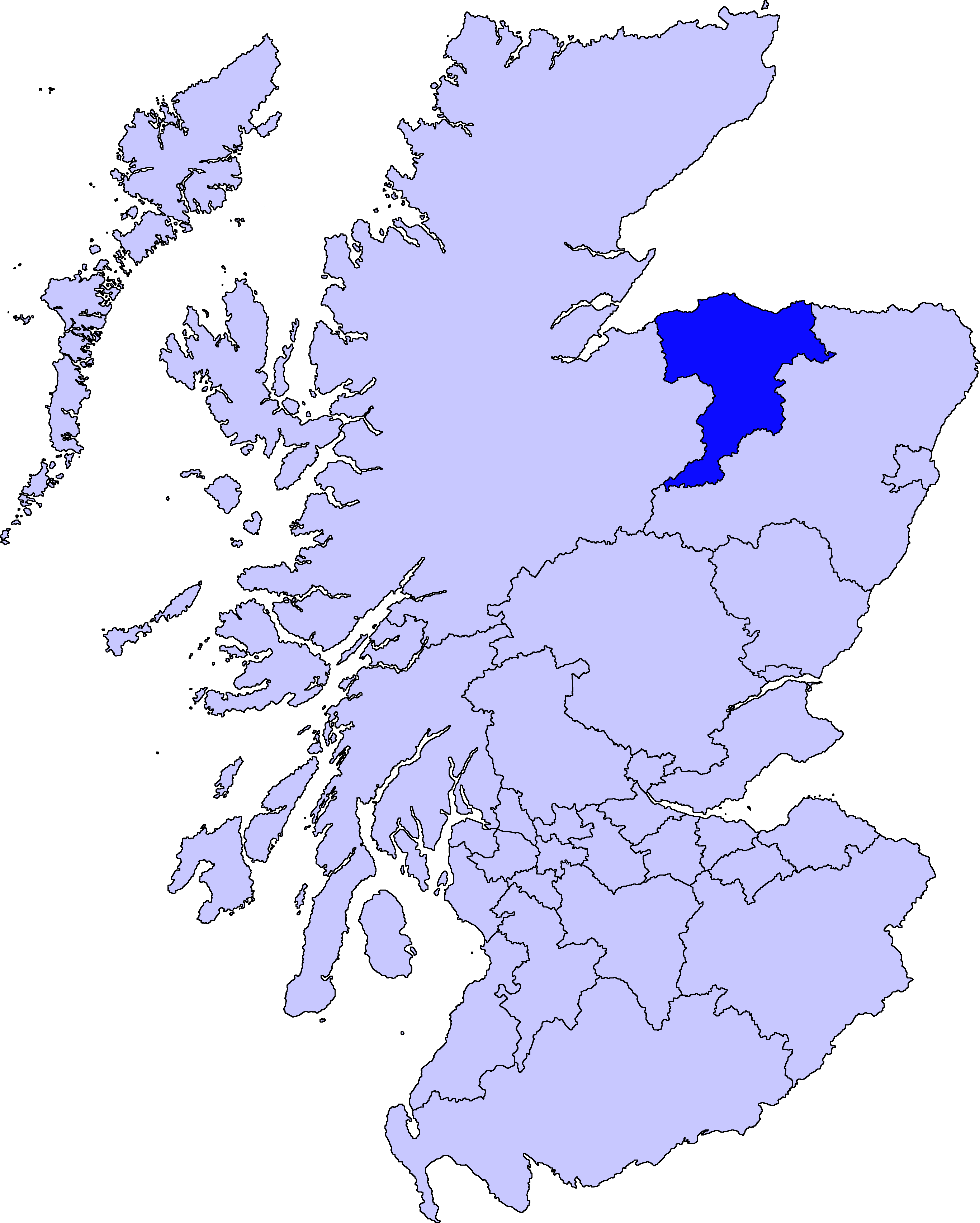
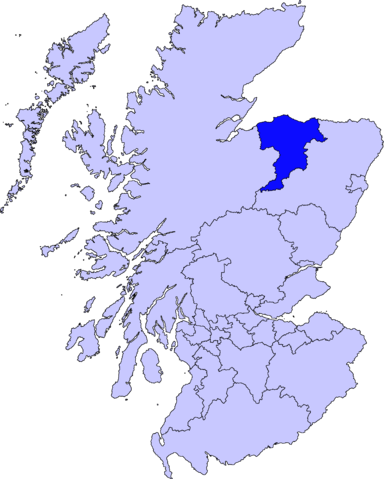
Moray unitary council
Slightly edited version of a map drawn by Morwen

|
Voit kopioida, levittää ja/tai muuttaa tätä asiakirjaa GNU Free Documentation License -lisenssin version 1.2 tai minkä tahansa Free Software Foundationin julkaiseman myöhemmän version ehtojen alaisena; ei koske muuttumattomia kohtia, etukannen tekstejä eikä takakannen tekstejä. Kopio tästä lisenssistä on saatavilla osiossa GNU Free Documentation License. |
| Tämä tiedosto on lisensoitu Creative Commons Nimeä-JaaSamoin 3.0 Ei sovitettu -lisenssillä. | ||
| ||
| Lisensointimerkintä lisätiin tähän tiedostoon osana GFDL-lisensointipäivitystä. |
Tiedoston historia
Päiväystä napsauttamalla näet, millainen tiedosto oli kyseisellä hetkellä.
| Päiväys | Pienoiskuva | Koko | Käyttäjä | Kommentti | |
|---|---|---|---|---|---|
| nykyinen | 11. elokuuta 2010 kello 04.46 | | 2 733 × 3 411 (216 KiB) | Alphathon | New, larger, transparent background version based on the Angus map |
| 18. toukokuuta 2005 kello 00.38 |  | 200 × 230 (4 KiB) | Voyager | Moray unitary council Slightly edited version of a map drawn by Morwen {{GFDL}} Category:Maps of Scottish unitary councils |
Tiedoston käyttö
Tätä tiedostoa ei käytetä millään sivulla.
Tiedoston järjestelmänlaajuinen käyttö
Seuraavat muut wikit käyttävät tätä tiedostoa:
- Käyttö kohteessa bg.wikipedia.org
- Käyttö kohteessa cy.wikipedia.org
- Käyttö kohteessa de.wikipedia.org
- Käyttö kohteessa en.wikipedia.org
- Maggieknockater
- Moray
- Elgin, Moray
- Dufftown
- Forres
- Lossiemouth
- Burghead
- Talk:Moray
- Buckie
- Findochty
- Fochabers
- Aberlour
- Cullen, Moray
- Tomintoul
- Keith, Moray
- Mosstodloch
- Archiestown
- Rothes
- Findhorn
- Kinloss, Scotland
- Portknockie
- Achnastank
- Drummuir
- Rathven
- Dallas, Moray
- Longmorn
- Kingston, Moray
- Auchindoun, Moray
- Fogwatt
- Craigellachie, Moray
- Newmill
- Cummingston
- Hopeman
- Duffus
- Ballindalloch
- Urquhart, Moray
- Lhanbryde
- Spey Bay
- Rafford
- Findhorn Ecovillage
- Ianstown
- Strathlene
- Alves, Moray
- Ashgrove, Moray
- Auchbreck
Näytä lisää tämän tiedoston järjestelmänlaajuista käyttöä.