Tiedosto:Republic of Lucca, Sanson-Jaillot 1672.png

Tämän esikatselun koko: 800 × 450 kuvapistettä. Muut resoluutiot: 320 × 180 kuvapistettä | 640 × 360 kuvapistettä | 1 024 × 576 kuvapistettä | 1 280 × 720 kuvapistettä | 1 920 × 1 080 kuvapistettä.
Alkuperäinen tiedosto (1 920 × 1 080 kuvapistettä, 3,46 MiB, MIME-tyyppi: image/png)
| Tämä tiedosto on tiedostotietokanta Wikimedia Commonsista. Tiedot kuvaussivulta näkyvät alla. |  |
Tiedoston kuvaussivu Commonsissa |
Yhteenveto
| Kuvaus |
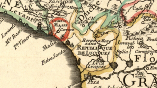
English: Detail of a French map of Italy published in the seconf hald of the 17th century showing the territory of the Republic of Lucca ("République de Lucques"). The enclave of Pietrasanta belonged to the Grand Duchy of Tuscany. Lucca was bordered to the northwest by the Duchy of Massa-Carrara, to the north by the Duchy of Modena, and to the east and south by the Grand Duchy of Tuscany. The map was designed by Guillaume Sanson and published in Paris by Hubert Jaillot in 1672. Title of the map: L'Italie divisée suivant l'estendue de toutes ses souverainetés: qui sont les Estats de l'Eglise, du Roy-Catholique qui comprennent les Royaumes de Naples, de Sicile, de Sardaigne, le Duchfé de Milan &c. |
| Päiväys | |
| Lähde | Moll's map collection |
| Tekijä | Guillaume Sanson (1630–1703) |
Lisenssi
|
Tämä teos on public domainissa lähes maailmanlaajuisesti, koska tekijän kuolemasta on kulunut yli 100 vuotta. | |
| Tämä teos on vapaa tunnetuista tekijänoikeuslain mukaisista rajoituksista, mukaanlukien lähioikeuksista. | |
Tiedoston historia
Päiväystä napsauttamalla näet, millainen tiedosto oli kyseisellä hetkellä.
| Päiväys | Pienoiskuva | Koko | Käyttäjä | Kommentti | |
|---|---|---|---|---|---|
| nykyinen | 8. syyskuuta 2018 kello 21.24 | | 1 920 × 1 080 (3,46 MiB) | Lubiesque | User created page with UploadWizard |
Tiedoston käyttö
Seuraava sivu käyttää tätä tiedostoa:
Tiedoston järjestelmänlaajuinen käyttö
Seuraavat muut wikit käyttävät tätä tiedostoa:
- Käyttö kohteessa la.wikipedia.org