Tiedosto:Premongol.png
Tarkempaa kuvaa ei ole saatavilla.
Premongol.png (752 × 590 kuvapistettä, 31 KiB, MIME-tyyppi: image/png)
| Tämä tiedosto on tiedostotietokanta Wikimedia Commonsista. Tiedot kuvaussivulta näkyvät alla. |  |
Tiedoston kuvaussivu Commonsissa |
Yhteenveto

|
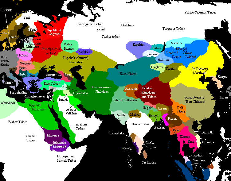
This map has been uploaded by Electionworld from en.wikipedia.org to enable the |
Eurasia on the eve of the Mongol invasions, c. 1200 CE. Source unknown. All of Central, North and East Asian states and tribes were located in wrong places.

|
Tämä tyyppiä historical map oleva kuva pitäisi luoda uudelleen SVG-tiedostoksi vektorigrafiikan avulla. Tällä tiedostotyypillä on monia vahvuuksia, sivulta Commons:Media for cleanup löytyy lisätietoja. Jos tästä kuvasta on jo olemassa SVG-versio, ole ystävällinen ja tallenna se tänne. SVG-tiedoston tallentamisen jälkeen vaihda tämä malline mallineeseen {{vector version available|uusi kuvan nimi.svg}}.
|
Lisenssi

|
Voit kopioida, levittää ja/tai muuttaa tätä asiakirjaa GNU Free Documentation License -lisenssin version 1.2 tai minkä tahansa Free Software Foundationin julkaiseman myöhemmän version ehtojen alaisena; ei koske muuttumattomia kohtia, etukannen tekstejä eikä takakannen tekstejä. Kopio tästä lisenssistä on saatavilla osiossa GNU Free Documentation License. |
| Tämä tiedosto on lisensoitu Creative Commons Nimeä-JaaSamoin 3.0 Ei sovitettu -lisenssillä. | ||
| ||
| Lisensointimerkintä lisätiin tähän tiedostoon osana GFDL-lisensointipäivitystä. |
See also

Original upload notes
20:43, 21 November 2006 . . Timmie.merc (talk | contribs | block) 752 × 590 (31,383 bytes) (Reverted to earlier revision)
20:42, 21 November 2006 . . Timmie.merc (talk | contribs | block) 752 × 590 (31,383 bytes) (Reverted to earlier revision)
17:31, 3 October 2006 . . Vilniškis (talk | contribs | block) 752 × 590 (31,383 bytes) (Eurasia on the eve of the Mongol invasions, c. 1200.)
17:26, 3 October 2006 . . Vilniškis (talk | contribs | block) 752 × 590 (31,383 bytes)
18:11, 26 September 2006 . . Nanshu (talk | contribs | block) 752 × 590 (20,501 bytes) (minor corrections on East Asia)
20:35, 6 June 2006 . . Foobaz (talk | contribs | block) 752 × 590 (20,505 bytes) (Changed name of Vietnam from Annam to Đại Việt as talk page suggested.)
12:26, 1 June 2006 . . Foobaz (talk | contribs | block) 752 × 590 (20,469 bytes) (fixed spelling error in Africa: "Berber Trubes" -> "Berber Tribes")
00:26, 14 January 2006 . . Briangotts (talk | contribs | block) 752 × 590 (45,292 bytes) (Eurasia on the eve of the Mongol invasions, c. 1200 CE. Category:Historical maps by User:Briangotts)
10:42, 22 December 2005 . . Briangotts (talk | contribs | block) 752 × 590 (44,927 bytes) (Eurasia on the eve of the Mongol invasions, c. 1200 CE. Category:Historical maps by User:Briangotts)
| Annotations | This image is annotated: View the annotations at Commons |
Tiedoston historia
Päiväystä napsauttamalla näet, millainen tiedosto oli kyseisellä hetkellä.
| Päiväys | Pienoiskuva | Koko | Käyttäjä | Kommentti | |
|---|---|---|---|---|---|
| nykyinen | 29. syyskuuta 2019 kello 16.27 | | 752 × 590 (31 KiB) | Бмхүн | incorrect{{DEFAULTSORT:<noinclude></noinclude>}} |
| 22. marraskuuta 2018 kello 22.04 |  | 752 × 590 (31 KiB) | Spiridon Ion Cepleanu | Reverted to version as of 19:35, 27 March 2014 (UTC) | |
| 8. maaliskuuta 2015 kello 23.59 |  | 3 240 × 1 903 (6,82 MiB) | Spiridon Ion Cepleanu | Modification after discussion with Khorichar and verifications in the Westermann Grosser Atlas zur Weltgeschichte (H.E.Stier, dir.), 1985. Perhaps new ameliorations may be tried. | |
| 3. maaliskuuta 2015 kello 17.49 |  | 752 × 590 (24 KiB) | Spiridon Ion Cepleanu | New precisions according with Khorichar's rectifications [https://commons.wikimedia.org/wiki/User_talk:Khorichar] | |
| 11. joulukuuta 2014 kello 20.40 |  | 752 × 590 (24 KiB) | Spiridon Ion Cepleanu | Some little details according with H.E.Stier (dir.) « Grosser Atlas zur Weltgeschichte », Westermann 1985, ISBN 3-14-100919-8, « Putzger historischer Weltatlas Cornelsen » 1990, ISBN 3-464-00176-8 & some other works. | |
| 27. maaliskuuta 2014 kello 22.35 |  | 752 × 590 (31 KiB) | Comnenus | Reverted to version as of 06:43, 5 March 2012 | |
| 4. elokuuta 2012 kello 14.44 |  | 752 × 590 (31 KiB) | محک | Tabaristan was Fals. | |
| 5. maaliskuuta 2012 kello 09.43 |  | 752 × 590 (31 KiB) | Ecthelion83 | 1. Added more geographical accuracy to Korean Peninsula 2. Cleaned up some of the artifacts from previous edits (i.e. spots of wrong color) 3. This map is meant to depict the Old World prior to the rise of the Mongol Empire, i.e. before the year 1190, ... | |
| 5. maaliskuuta 2012 kello 09.43 |  | 752 × 590 (137 KiB) | Ecthelion83 | 1. Added more geographical accuracy to Korean Peninsula 2. Cleaned up some of the artifacts from previous edits (i.e. spots of wrong color) 3. This map is meant to depict the Old World prior to the rise of the Mongol Empire, i.e. before the year 1190, ... | |
| 21. syyskuuta 2011 kello 17.44 |  | 752 × 590 (137 KiB) | Comnenus | Reverted to version as of 18:29, 20 August 2011 Venice did not rule those territories in 1200. |
Tiedoston käyttö
Tätä tiedostoa ei käytetä millään sivulla.
Tiedoston järjestelmänlaajuinen käyttö
Seuraavat muut wikit käyttävät tätä tiedostoa:
- Käyttö kohteessa ar.wikipedia.org
- Käyttö kohteessa azb.wikipedia.org
- Käyttö kohteessa ca.wikipedia.org
- Käyttö kohteessa de.wikipedia.org
- Käyttö kohteessa de.wikiversity.org
- Käyttö kohteessa en.wikipedia.org
- Käyttö kohteessa en.wikibooks.org
- Käyttö kohteessa es.wikipedia.org
- Käyttö kohteessa et.wikipedia.org
- Käyttö kohteessa fa.wikipedia.org
- Käyttö kohteessa fr.wikipedia.org
- Käyttö kohteessa hi.wikipedia.org
- Käyttö kohteessa it.wikipedia.org
- Käyttö kohteessa mn.wikipedia.org
- Käyttö kohteessa pnb.wikipedia.org
- Käyttö kohteessa ru.wikipedia.org
- Käyttö kohteessa ta.wikipedia.org
- Käyttö kohteessa tl.wikipedia.org
- Käyttö kohteessa www.wikidata.org