Tiedosto:Plan Odendaal.png
Tarkempaa kuvaa ei ole saatavilla.
Plan_Odendaal.png (418 × 418 kuvapistettä, 33 KiB, MIME-tyyppi: image/png)
| Tämä tiedosto on tiedostotietokanta Wikimedia Commonsista. Tiedot kuvaussivulta näkyvät alla. |  |
Tiedoston kuvaussivu Commonsissa |

|
Tämä tyyppiä map oleva kuva pitäisi luoda uudelleen SVG-tiedostoksi vektorigrafiikan avulla. Tällä tiedostotyypillä on monia vahvuuksia, sivulta Commons:Media for cleanup löytyy lisätietoja. Jos tästä kuvasta on jo olemassa SVG-versio, ole ystävällinen ja tallenna se tänne. SVG-tiedoston tallentamisen jälkeen vaihda tämä malline mallineeseen {{vector version available|uusi kuvan nimi.svg}}.
|
Yhteenveto
| Kuvaus |
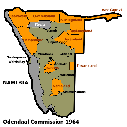
Español: Bantustanes en el territorio de Namibia con Damaraland al noroeste del país
English: This map shows the Odendaal Commission Plan for Namibia of 1964. The plan divided Namibia into Bantustans or Homelands. |
||||||||
| Päiväys | |||||||||
| Lähde | |||||||||
| Tekijä | Bries | ||||||||
| Käyttöoikeus (Tämän tiedoston uudelleenkäyttö) |
|
||||||||
| Muut versiot | French version : Image:Plan_Odendaal-fr.png |

Tiedoston historia
Päiväystä napsauttamalla näet, millainen tiedosto oli kyseisellä hetkellä.
| Päiväys | Pienoiskuva | Koko | Käyttäjä | Kommentti | |
|---|---|---|---|---|---|
| nykyinen | 26. marraskuuta 2023 kello 01.00 | | 418 × 418 (33 KiB) | LoomCreek | Transparency |
| 21. huhtikuuta 2005 kello 10.40 |  | 418 × 418 (15 KiB) | Bries | This map shows the Odendaal Commission Plan for Namibia of 1964. The plan divided Namibia into ''Bantustans'' or ''Homelands''. I have created the map for the Wikipedia community. Category:Maps of Namibia {{GFDL}} |
Tiedoston käyttö
Seuraava sivu käyttää tätä tiedostoa:
Tiedoston järjestelmänlaajuinen käyttö
Seuraavat muut wikit käyttävät tätä tiedostoa:
- Käyttö kohteessa af.wikipedia.org
- Käyttö kohteessa ar.wikipedia.org
- Käyttö kohteessa ast.wikipedia.org
- Käyttö kohteessa bn.wikipedia.org
- Käyttö kohteessa ca.wikipedia.org
- Bantustan
- Hereros
- Resolució 301 del Consell de Seguretat de les Nacions Unides
- Resolució 309 del Consell de Seguretat de les Nacions Unides
- Resolució 310 del Consell de Seguretat de les Nacions Unides
- Resolució 319 del Consell de Seguretat de les Nacions Unides
- Resolució 323 del Consell de Seguretat de les Nacions Unides
- Resolució 342 del Consell de Seguretat de les Nacions Unides
- Resolució 366 del Consell de Seguretat de les Nacions Unides
- Käyttö kohteessa ckb.wikipedia.org
- Käyttö kohteessa de.wikipedia.org
- Käyttö kohteessa en.wikipedia.org
- South West Africa
- History of Namibia
- Bantustan
- Kaokoland
- Bushmanland (South West Africa)
- Hereroland
- Ovamboland
- Damaraland
- Tswanaland
- Kavangoland
- Rehoboth (homeland)
- Namaland
- East Caprivi
- Fox Odendaal
- Diocese of Namibia
- United Nations Security Council Resolution 301
- Land reform in Namibia
- Aminuis
- Constance Kgosiemang
- Käyttö kohteessa es.wikipedia.org
Näytä lisää tämän tiedoston järjestelmänlaajuista käyttöä.