Tiedosto:PfaffensprungSpiralTunnel DoubleLoopCurvedAlignmentTunnels atWassen onNorthernRampToGotthardTunnel.jpg
Alkuperäinen tiedosto (1 592 × 518 kuvapistettä, 107 KiB, MIME-tyyppi: image/jpeg)
| Tämä tiedosto on tiedostotietokanta Wikimedia Commonsista. Tiedot kuvaussivulta näkyvät alla. |  |
Tiedoston kuvaussivu Commonsissa |
Yhteenveto
| Kuvaus |
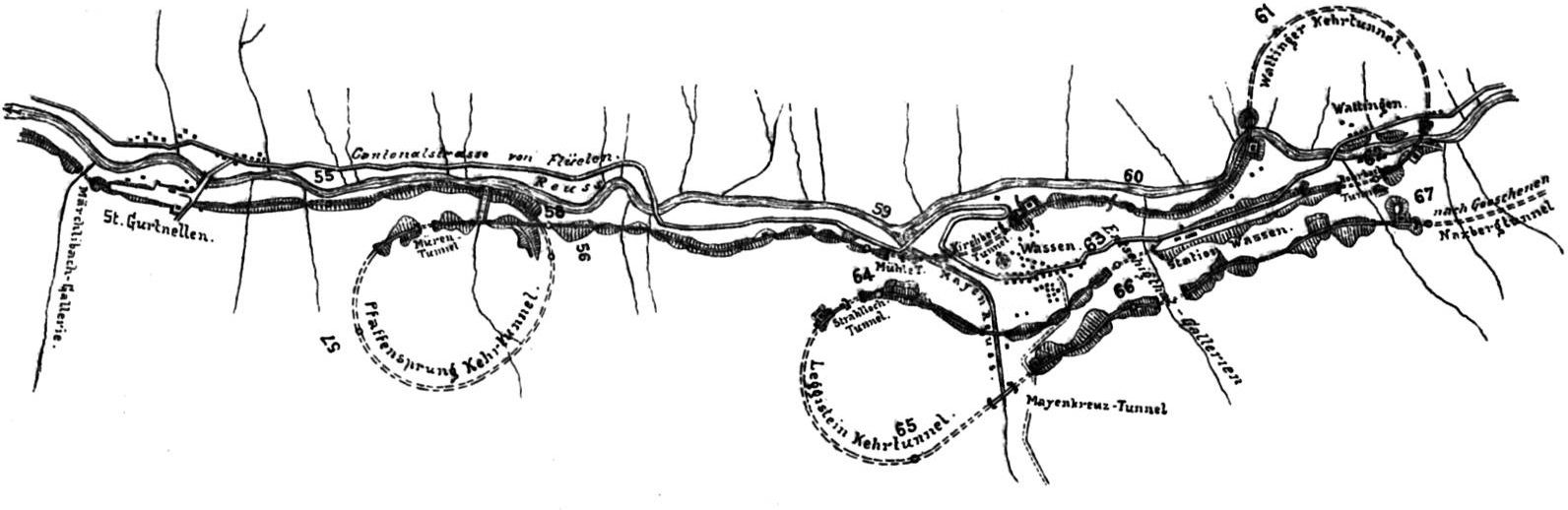
English: Outline of the Pfaffensprung spiral tunnel and the double loop at Wassen on the northern ramp to the Gotthard tunnel. Deutsch: Pfaffensprung-Kehrtunnel und Linienentwicklung bei Wassen. |
||||
| Päiväys | 1914, book (or prior source predating the publication of volume 5 of Röll's encyclopedia in 1914) | ||||
| Lähde | Gotthardbahn in: Röll, V. Freiherr von: Enzyklopädie des Eisenbahnwesens, Band 5. Berlin, Wien 1914, S. 354-361. digitized version on www.zeno.org/Roell-1912 | ||||
| Tekijä | Dietler, Hermann (1839-10-01 - 1924-01-24); Röll, Victor Freiherr von (1852-05-22 - 1922-10-12) | ||||
| Käyttöoikeus (Tämän tiedoston uudelleenkäyttö) |
|
||||
The original German caption of the graph in the cited publication reads "Abb. 289. Pfaffensprung-Kehrtunnel und Linienentwicklung bei Wassen."
No scale or legend was provided with the map.
The travel distance along the Gotthard line from Immensee is indicated for each full kilometer by a small circular mark and the specified distance in km.
The km position for the Lavorgo station is with 112.6 the same as today, whereas todays km position of the Giornico station 121.7 differs from the 120 indicated in the illustration by 1.7km. At this point it is unclear where this discrepancy comes from. One theory might be that a new railway station was built 1.7km down the line from the original one. (The above links point to the German Wikipedia article because the zero-point for the distance measurement at Immensee is clearer established in the route-diagramm on the right than in the English version of this diagramm.)
Going North on the Gotthardbahn having passed Göschenen station you enter the Leggistein spiral tunnel doing a 240° right turn followed by a 60° left turn i.e. in total a 180° turn entering Wassen station. Proceeding from Wassen you enter the Wattinger turn tunnel doing a 240° left turn followed by a 60° right turn, again in total a 180° turn. Continuing for 2 kilometers in a straightish line you pass the 360° Pfaffensprung spiral tunnel before entering the Gurtnellen station. Exiting there you contine your descent the last stretch of the northern ramp to Erstfeld.
The author Dietler did not provide a copyright for the graphs used nor did he use specific citations within his article and listed sources as "literature" solely at the end of his chapter. It is not clear if he is the original author of any of the illustrations or whether he copied them from one of the books or periodicals listed or from elsewhere. Disregarding the listed business reports of the Gotthardbahn and its liquidation commission the most recent dated literature listed originates from 1895. Obviously all listed sources predate the publication of volume 5 of Röll's encyclopedia in 1914. Dietler lists the sources as follows below. Originals of the graph might be found there. With standard operation of the Gotthardbahn having started on 1 June 1882 the line was well established during the publication of of volume 5 of Röll's encyclopedia in 1915. The engineering drawing probably dates from somewhere between the final planning period and the time just before the last construction phase.
Literatur of the article:
- – Die Gotthardbahn in kommerzieller Beziehung. Zürich 1864.
- – Begründung von Distanztabellen, graph. Darstellung der Verkehrsgebiete. Basel 1864.
- – Die Gotthardbahn in technischer Beziehung, enthaltend die technischen Gutachten von Beckh und Gerwig, Dezember 1864, und von Wetli, Januar 1865, sowie eine Rentabilitätsberechnung von Koller, Schmidlin u. Stoll, März 1865. Zürich.
- – Koller, Schmidlin und Stoll, Die Gotthardbahn und ihre Konkurrenten. Zürich, August 1865.
- – Koller, Schmidlin und Stoll, Die Gotthardbahn und der Luckmanier. Zürich, Oktober 1865.
- – Les projets de chemins de fer par les alpes helvétiques. Zürich 1869.
- – Conférences internationales pour la construction du chemin de fer par le St. Gotthard, tenues à Berne, Procès-Verbal des Séances, 15 Septembre – 13 Octobre 1869.
- – Hellwag, Die Bahnachse und das Längenprofil der Gotthardbahn nebst approximativem Kostenvoranschlag und die Ursachen der Überschreitung des Voranschlags der tessinischen Bahnen, Zürich, 3. und 6. Februar 1876.
- – Expertise concernant le chemin de fer du St. Gothard, Commission Plénèire et Sous-Commission, Procès-Verbal des Séances, 31 Juliett – 22 Novembre 1876. Bern.
- – Conférences internationales pour la construction du chemin de fer par le St. Gothard tenues à Lucerne, Procès-Verbal des Séances, 4–13 Juin 1877.
- – Erster bis achtunddreißigster Geschäftsbericht der Direktion und des Verwaltungsrates der Gotthardbahn über den Zeitraum vom 6. Dezember 1871 bis 30. April 1909; drei Geschäftsberichte der Liquidationskommission über den Zeitraum vom 1. Mai 1909 bis 30. Juni 1912.
- – Rapports mensuels et trimestriels du Conseil federal suisse sur l'état des travaux de la ligne du St. Gothard.
- – Wanner, Geschichte der Begründung des Gotthardbahnunternehmens. Luzern 1880.
- – Dolezalek, Die Gotthardbahn. Hann. Ztschr. 1882.
- – Wanner, Rückblick auf die Entstehung und den Bau der Gotthardbahn. Luzern 1882.
- – Wanner, Geschichte des Baffes der Gotthardbahn. Luzern 1885.
- – Stapff, Geologische Übersichtskarte der Gotthardbahnstrecke Erstfeld-Castione, 10 Blätter 1 : 25.000. Berlin 1885.
- – Mémoire du Département Fédéral Suisse des chemins de fer sur la construction du chemin de fer du St. Gothard. Bern 1888.
- – Rich. Bechtle, Die Gotthardbahn. Stuttgart 1895.
Lisenssi
|
Tämä teos on public domainissa lähes maailmanlaajuisesti, koska tekijän kuolemasta on kulunut yli 70 vuotta.
| |
| Tämä teos on vapaa tunnetuista tekijänoikeuslain mukaisista rajoituksista, mukaanlukien lähioikeuksista. | |
Tiedoston historia
Päiväystä napsauttamalla näet, millainen tiedosto oli kyseisellä hetkellä.
| Päiväys | Pienoiskuva | Koko | Käyttäjä | Kommentti | |
|---|---|---|---|---|---|
| nykyinen | 18. elokuuta 2009 kello 05.09 | 1 592 × 518 (107 KiB) | PasoAPaso | {{Information |Description={{en|1=Outline of the Pfaffensprung spiral tunnel and the double loop at Wassen on the northern ramp to the Gotthard tunnel. }} |Source=Gotthardbahn in: Röll, V. Freiherr von: Enzyklopädie des Eisenbahnwesens, Band 5. Berlin, |
Tiedoston käyttö
Seuraava sivu käyttää tätä tiedostoa:
Tiedoston järjestelmänlaajuinen käyttö
Seuraavat muut wikit käyttävät tätä tiedostoa:
- Käyttö sivustolla de.wikipedia.org
- Käyttö sivustolla en.wikipedia.org
- Käyttö sivustolla ja.wikipedia.org
- Käyttö sivustolla nl.wikipedia.org
- Käyttö sivustolla pt.wikipedia.org