Tiedosto:Parisattacks.png
Tämän esikatselun koko: 279 × 598 kuvapistettä. Muut resoluutiot: 112 × 240 kuvapistettä | 224 × 480 kuvapistettä | 358 × 768 kuvapistettä | 477 × 1 024 kuvapistettä | 1 946 × 4 171 kuvapistettä.
Alkuperäinen tiedosto (1 946 × 4 171 kuvapistettä, 12,78 MiB, MIME-tyyppi: image/png)
| Tämä tiedosto on tiedostotietokanta Wikimedia Commonsista. Tiedot kuvaussivulta näkyvät alla. |  |
Tiedoston kuvaussivu Commonsissa |

|
Tämä tyyppiä map oleva kuva pitäisi luoda uudelleen SVG-tiedostoksi vektorigrafiikan avulla. Tällä tiedostotyypillä on monia vahvuuksia, sivulta Commons:Media for cleanup löytyy lisätietoja. Jos tästä kuvasta on jo olemassa SVG-versio, ole ystävällinen ja tallenna se tänne. SVG-tiedoston tallentamisen jälkeen vaihda tämä malline mallineeseen {{vector version available|uusi kuvan nimi.svg}}.
|
| Kuvaus |
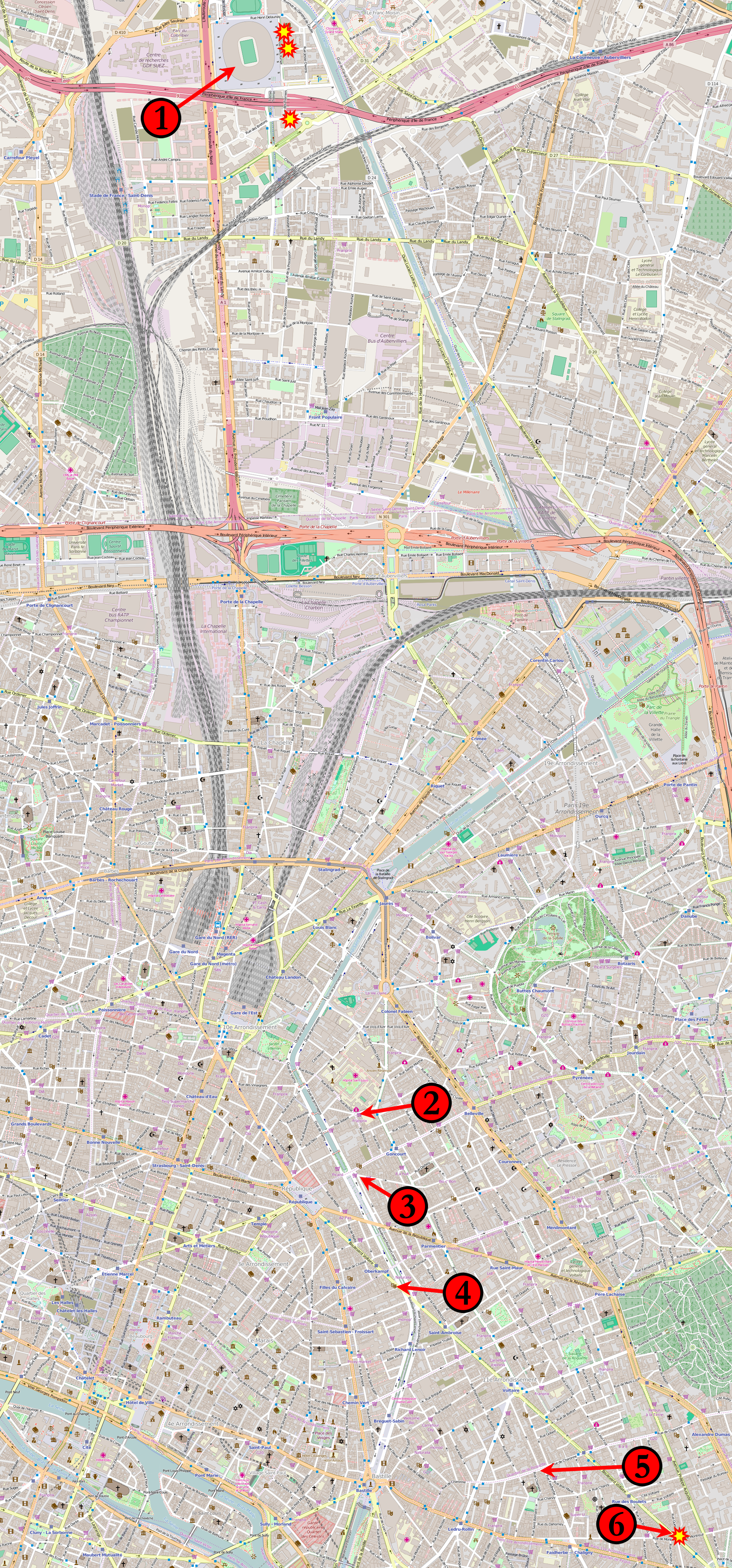
Français : Carte de novembre 2015, attaques parisiennes coordonnées.
(1) 21 h 20, 21 h 30, 21 h 53 : Stade de France à Saint-Denis. (2) 21 h 25 : Le Carillon, croisement des rues Alibert et Bichat et Le petit Cambodge, rue Alibert. (3) 21 h 32 : Café Bonne Bière, rue du Faubourg-du-Temple et Casa Nostra, rue de la Fontaine-au-Roi. (4) 21 h 40 : Le Bataclan, bar-concert, boulevard Voltaire. (5) 21 h 36 : La Belle Équipe, rue de Charonne. (6) 21 h 46 : Comptoir Voltaire, boulevard Voltaire. Étoiles : Attaques suicide à la ceinture explosive autour du Stade de France et du restaurant Comptoir Voltaire. Les kamikazes du Bataclan ne sont pas identifiés individuellement. English: Map of the November 2015 Paris attacks in relation to each other.
(1) 21:20, 21:30, 21:53 : Stade de France in Saint-Denis. (2) 21:25 : Le Carillon, junction of rue Bichat and rue Alibert and Le petit Cambodge, rue Alibert. (3) 21:32 : Café Bonne Bière, rue du Faubourg-du-Temple and Casa Nostra, rue de la Fontaine-au-Roi. (4) 21:40 : Le Bataclan theatre. (5) 21:36 : La Belle Équipe, rue de Charonne. (6) 21:46 : Comptoir Voltaire, boulevard Voltaire. Stars: Individual suicide bombings around the Stade de France and the Comptoir Voltaire restaurant. The suicide bombings at Le Bataclan are not individually distinguished. Čeština: Mapa míst teroristických útoků v Paříži:
1) Stade de France 2) křížení ulic Rue Bichat a Rue Alibert 3) Casa Nostra, Rue de la Fontaine-au-Roi 4) koncertní sál Bataclan 5) Rue de Charonne 6) Comptoir Voltaire, boulevard Voltaire. Русский: Карта мест террористических актов в Париже 13 ноября 2015 года: 1) «Стад де Франс» 2) пересечение улиц Rue Bichat и Rue Alibert 3) Casa Nostra, Rue de la Fontaine 4) концертный зал театра «Батаклан» 5) улица Rue de Charonne |
|||
| Päiväys | ||||
| Lähde | Base map from OpenStreetMap | |||
| Tekijä | Veggies | |||
| Käyttöoikeus (Tämän tiedoston uudelleenkäyttö) |
Tämä tiedosto on lisensoitu Creative Commons Nimeä-JaaSamoin 2.0 Yleinen -lisenssillä.
|
|||
| Muut versiot |
 |
Tiedoston historia
Päiväystä napsauttamalla näet, millainen tiedosto oli kyseisellä hetkellä.
| Päiväys | Pienoiskuva | Koko | Käyttäjä | Kommentti | |
|---|---|---|---|---|---|
| nykyinen | 20. marraskuuta 2015 kello 14.15 | | 1 946 × 4 171 (12,78 MiB) | Veggies | Returning to original size. Map is unreadable in reduced version. |
| 19. marraskuuta 2015 kello 23.11 |  | 933 × 2 000 (3,85 MiB) | Flappiefh | Reduced the size of the picture to relieve Wikimedia servers. | |
| 18. marraskuuta 2015 kello 21.27 |  | 1 946 × 4 171 (14,59 MiB) | Flappiefh | Added a number next to the kamikaze attack near the Comptoir Voltaire. | |
| 15. marraskuuta 2015 kello 07.18 |  | 1 946 × 4 171 (12,79 MiB) | Veggies | Added the locations for the individual suicide bombings around the stadium and at the Comptoir Voltaire restaurant on Boulevard Voltaire. | |
| 14. marraskuuta 2015 kello 16.15 |  | 1 946 × 4 171 (12,77 MiB) | Veggies | Changed numbers to match order of attacks, added Casa Nostra location | |
| 14. marraskuuta 2015 kello 08.17 |  | 1 946 × 4 171 (12,78 MiB) | Veggies | {{Information |Description ={{en|1=Map of the November 2015 Paris attacks in relation to each other.}} |Source =Base map from [https://www.openstreetmap.org OpenStreetMap] |Author =Veggies |Date =2014-11-14... |
Tiedoston käyttö
Seuraava sivu käyttää tätä tiedostoa:
Tiedoston järjestelmänlaajuinen käyttö
Seuraavat muut wikit käyttävät tätä tiedostoa:
- Käyttö kohteessa ar.wikipedia.org
- Käyttö kohteessa arz.wikipedia.org
- Käyttö kohteessa as.wikipedia.org
- Käyttö kohteessa az.wikipedia.org
- Käyttö kohteessa bat-smg.wikipedia.org
- Käyttö kohteessa bg.wikipedia.org
- Käyttö kohteessa bn.wikipedia.org
- Käyttö kohteessa br.wikipedia.org
- Käyttö kohteessa bs.wikipedia.org
- Käyttö kohteessa ca.wikipedia.org
- Käyttö kohteessa ca.wikinews.org
- Käyttö kohteessa cs.wikipedia.org
- Käyttö kohteessa cs.wikinews.org
- Käyttö kohteessa da.wikipedia.org
- Käyttö kohteessa diq.wikipedia.org
- Käyttö kohteessa el.wikipedia.org
- Käyttö kohteessa en.wikipedia.org
- Käyttö kohteessa eo.wikipedia.org
- Käyttö kohteessa eo.wikinews.org
- Käyttö kohteessa es.wikipedia.org
- Käyttö kohteessa et.wikipedia.org
- Käyttö kohteessa eu.wikipedia.org
- Käyttö kohteessa fa.wikipedia.org
- Käyttö kohteessa fo.wikipedia.org
- Käyttö kohteessa fr.wikipedia.org
- Käyttö kohteessa fr.wikinews.org
- Käyttö kohteessa ga.wikipedia.org
- Käyttö kohteessa glk.wikipedia.org
- Käyttö kohteessa gl.wikipedia.org
- Käyttö kohteessa he.wikipedia.org
- Käyttö kohteessa hi.wikipedia.org
- Käyttö kohteessa hr.wikipedia.org
- Käyttö kohteessa hu.wikipedia.org
- Käyttö kohteessa hy.wikipedia.org
- Käyttö kohteessa id.wikipedia.org
- Käyttö kohteessa io.wikipedia.org
- Käyttö kohteessa is.wikipedia.org
- Käyttö kohteessa it.wikinews.org
- Käyttö kohteessa ja.wikipedia.org
- Käyttö kohteessa kk.wikipedia.org
Näytä lisää tämän tiedoston järjestelmänlaajuista käyttöä.