Tiedosto:North Caucasus topographic map-fr.svg

Tämän PNG-esikatselun koko koskien SVG-tiedostoa: 800 × 392 kuvapistettä. Muut resoluutiot: 320 × 157 kuvapistettä | 640 × 313 kuvapistettä | 1 024 × 501 kuvapistettä | 1 280 × 626 kuvapistettä | 2 560 × 1 253 kuvapistettä | 805 × 394 kuvapistettä.
Alkuperäinen tiedosto (SVG-tiedosto; oletustarkkuus 805 × 394 kuvapistettä; tiedostokoko 3,89 MiB)
| Tämä tiedosto on tiedostotietokanta Wikimedia Commonsista. Tiedot kuvaussivulta näkyvät alla. |  |
Tiedoston kuvaussivu Commonsissa |
Yhteenveto
| Kuvaus |
|
| Päiväys | |
| Lähde |
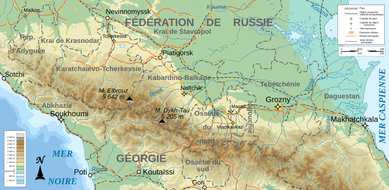
English: Own work ; Topographic data from the NASA Shuttle Radar Topography Mission (SRTM3 v.2) (public domain) edited with 3DEM, reprojected in UTM with GDAL (GDAL), and vectorized with Inkscape ; UTM projection ; WGS84 datum ; shaded relief (composite image of N-W, W and N lightning positions) ; Reference used for the additional data : * Rivers, cities, railroads, routes, bathymetry : Demis add-on for World Wind (see the approval e-mail and the Demis forum) ; * Borders and coast : World data bank II ; Approximate scale of topographic data : 1:1,463,000 ; Note : The shaded relief is a raster image embedded in the SVG file. Français : Création personnelle ; Données topographiques de la NASA Shuttle Radar Topography Mission (SRTM3 v.2) (domaine public) éditées avec 3DEM, reprojetées en UTM avec GDAL et vectorisées avec Inkscape ; projection UTM ; WGS84 datum ; relief ombré (image composite d'éclairages du N-O, O et N) ; Références utilisées pour les données complémentaires : * Rivières, villes, chemins de fers, routes, bathymétrie : Demis add-on for World Wind (cf. l'e-mail d'approbation de Demis et le Demis forum) ; * Frontières et côtes : World data bank II ; Note : Le relief ombré est une image bitmap embarquée dans le fichier SVG. |
| Tekijä | Bourrichon - fr:Bourrichon) |
| Käyttöoikeus (Tämän tiedoston uudelleenkäyttö) |
GFDL / Attribution and Share-Alike required |
| Muut versiot |
Tämän tiedoston johdannaisteoksia: North Caucasus topographic map-es.svg
|


|
Tässä SVG-tiedostossa on tekstiä, jonka voi kääntää helposti suomen kielelle käyttäen SVG-editoria kuten Inkscapea tai Adobe Illustratoria. Lisätietoja on sivulla Commons:Translation possible/Learn more. Voit myös ladata ja tallentaa sen, ja kääntää sen manuaalisesti tekstimuokkaimella. |
Lisenssi
Minä, tämän teoksen tekijänoikeuksien haltija, julkaisen täten tämän teoksen seuraavilla lisensseillä:

|
Voit kopioida, levittää ja/tai muuttaa tätä asiakirjaa GNU Free Documentation License -lisenssin version 1.2 tai minkä tahansa Free Software Foundationin julkaiseman myöhemmän version ehtojen alaisena; ei koske muuttumattomia kohtia, etukannen tekstejä eikä takakannen tekstejä. Kopio tästä lisenssistä on saatavilla osiossa GNU Free Documentation License. |
This file is licensed under the Creative Commons Attribution-Share Alike 4.0 International, 3.0 Unported, 2.5 Generic, 2.0 Generic and 1.0 Generic license.
- Voit:
- jakaa – kopioida, levittää ja esittää teosta
- remiksata – valmistaa muutettuja teoksia
- Seuraavilla ehdoilla:
- nimeäminen – Sinun on mainittava lähde asianmukaisesti, tarjottava linkki lisenssiin sekä merkittävä, mikäli olet tehnyt muutoksia. Voit tehdä yllä olevan millä tahansa kohtuullisella tavalla, mutta et siten, että annat ymmärtää lisenssinantajan suosittelevan sinua tai teoksen käyttöäsi.
- jaa samoin – Jos muutat tai perustat tähän työhön, voit jakaa tuloksena syntyvää työtä vain tällä tai tämän kaltaisella lisenssillä.
Voit valita haluamasi lisenssin.
Tiedoston historia
Päiväystä napsauttamalla näet, millainen tiedosto oli kyseisellä hetkellä.
| Päiväys | Pienoiskuva | Koko | Käyttäjä | Kommentti | |
|---|---|---|---|---|---|
| nykyinen | 15. helmikuuta 2023 kello 03.13 | | 805 × 394 (3,89 MiB) | Takhirgeran Umar | Reverted to version as of 21:08, 13 January 2020 (UTC) |
| 1. helmikuuta 2023 kello 04.44 |  | 805 × 394 (3,89 MiB) | Niyskho | Reverted to version as of 16:42, 8 November 2008 (UTC) | |
| 14. tammikuuta 2020 kello 00.08 |  | 805 × 394 (3,89 MiB) | Takhirgeran Umar | Clarification | |
| 9. marraskuuta 2008 kello 20.27 |  | 805 × 394 (3,89 MiB) | Bourrichon | ||
| 8. marraskuuta 2008 kello 19.42 |  | 805 × 394 (3,89 MiB) | Bourrichon | == Summary == {{Information |Description={{de|Topographische Karte von Nordkaukasus, französische Version}}{{en|Topographic map in French of North Caucasus}}{{fr|Carte topographique en français de la [[:fr:Cis |
Tiedoston käyttö
Seuraava sivu käyttää tätä tiedostoa:
Tiedoston järjestelmänlaajuinen käyttö
Seuraavat muut wikit käyttävät tätä tiedostoa:
- Käyttö kohteessa en.wikipedia.org
- Käyttö kohteessa en.wikinews.org
- Käyttö kohteessa fr.wikipedia.org
- Käyttö kohteessa incubator.wikimedia.org
- Käyttö kohteessa vi.wikipedia.org