Tiedosto:NEAT GBT engl.png

Tämän esikatselun koko: 539 × 600 kuvapistettä. Muut resoluutiot: 216 × 240 kuvapistettä | 431 × 480 kuvapistettä | 852 × 948 kuvapistettä.
Alkuperäinen tiedosto (852 × 948 kuvapistettä, 1,91 MiB, MIME-tyyppi: image/png)
| Tämä tiedosto on tiedostotietokanta Wikimedia Commonsista. Tiedot kuvaussivulta näkyvät alla. |  |
Tiedoston kuvaussivu Commonsissa |
Yhteenveto
| Kuvaus |
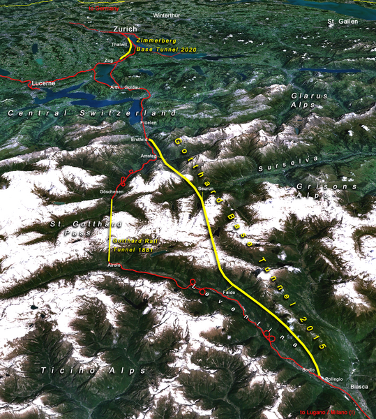
Situation of the northern part of the Gotthard axis as part of the New Railway Link through the Alps NRLA / Alptransit project in Switzerland with Gotthard and Zimmerberg base tunnels |
| Päiväys | |
| Lähde | topomap: produced with NASA WorldWind 1.3 / overlay drawing by: Cooper.ch |
| Tekijä | --Cooper.ch 19:30, 12 August 2006 (UTC) |
| Käyttöoikeus (Tämän tiedoston uudelleenkäyttö) |
NASA satellite imagery is in public domain, and so is my overlay drawing |
| Muut versiot | Original german version on de.wikipedia.org, named Bild:NEAT_Gotthardachse.png |
Lisenssi
| Tämä teos on ilman tekijänoikeuden suojaa, koska National Aeronautics and Space Administration (NASA) loi sen. Koska Nasa on Yhdysvaltain liittovaltion organisaatio, sen luomat teokset ovat ilman tekijänoikeuden suojaa. ([1][2]) | ||
 |
Varoitukset:
|
| Annotations | This image is annotated: View the annotations at Commons |


Tiedoston historia
Päiväystä napsauttamalla näet, millainen tiedosto oli kyseisellä hetkellä.
| Päiväys | Pienoiskuva | Koko | Käyttäjä | Kommentti | |
|---|---|---|---|---|---|
| nykyinen | 12. elokuuta 2006 kello 22.30 | | 852 × 948 (1,91 MiB) | Cooper.ch | {{Information |Description=Situation of the northern axis of the New Railway Link through the Alps NRLA in Switzerland with Gotthard and Zimmerberg base tunnels |Source=topomap: produced with NASA WorldWind 1.3 / drawing overlay by: [[User:Cooper.ch|Coope |
Tiedoston käyttö
Seuraava sivu käyttää tätä tiedostoa:
Tiedoston järjestelmänlaajuinen käyttö
Seuraavat muut wikit käyttävät tätä tiedostoa:
- Käyttö kohteessa ast.wikipedia.org
- Käyttö kohteessa bh.wikipedia.org
- Käyttö kohteessa da.wikipedia.org
- Käyttö kohteessa en.wikipedia.org
- Käyttö kohteessa es.wikipedia.org
- Käyttö kohteessa fa.wikipedia.org
- Käyttö kohteessa fr.wikipedia.org
- Käyttö kohteessa he.wikipedia.org
- Käyttö kohteessa hr.wikipedia.org
- Käyttö kohteessa ja.wikipedia.org
- Käyttö kohteessa jv.wikipedia.org
- Käyttö kohteessa ml.wikipedia.org
- Käyttö kohteessa my.wikipedia.org
- Käyttö kohteessa nl.wikipedia.org
- Käyttö kohteessa no.wikipedia.org
- Käyttö kohteessa pt.wikipedia.org
- Käyttö kohteessa rm.wikipedia.org
- Käyttö kohteessa ro.wikipedia.org
- Käyttö kohteessa sh.wikipedia.org
- Käyttö kohteessa sl.wikipedia.org
- Käyttö kohteessa sv.wikipedia.org
- Käyttö kohteessa ta.wikinews.org
- Käyttö kohteessa tr.wikipedia.org
- Käyttö kohteessa zh.wikipedia.org