Tiedosto:Map of Rhode Island NA.png
Tämän esikatselun koko: 776 × 600 kuvapistettä. Muut resoluutiot: 311 × 240 kuvapistettä | 621 × 480 kuvapistettä | 994 × 768 kuvapistettä | 1 280 × 989 kuvapistettä | 2 122 × 1 640 kuvapistettä.
Alkuperäinen tiedosto (2 122 × 1 640 kuvapistettä, 822 KiB, MIME-tyyppi: image/png)
| Tämä tiedosto on tiedostotietokanta Wikimedia Commonsista. Tiedot kuvaussivulta näkyvät alla. |  |
Tiedoston kuvaussivu Commonsissa |
Yhteenveto
| Kuvaus |
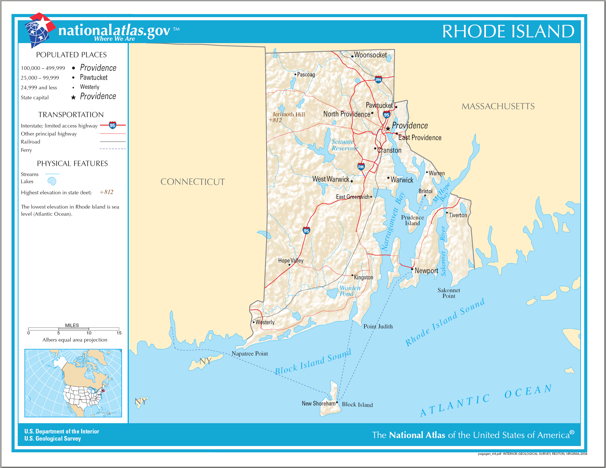
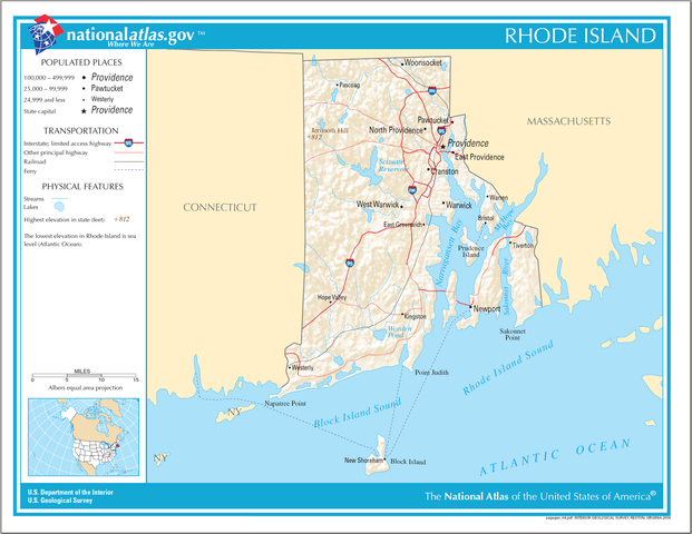
English: National Atlas map of Rhode Island. |
| Päiväys | |
| Lähde | National Atlas |
| Tekijä |
Lisenssi
This map was obtained from an edition of the National Atlas of the United States. Like almost all works of the U.S. federal government, works from the National Atlas are in the public domain in the United States.
Online access: NationalAtlas.gov | 1970 print edition: Library of Congress, Perry-Castañeda Library
|
Tiedoston historia
Päiväystä napsauttamalla näet, millainen tiedosto oli kyseisellä hetkellä.
| Päiväys | Pienoiskuva | Koko | Käyttäjä | Kommentti | |
|---|---|---|---|---|---|
| nykyinen | 17. huhtikuuta 2015 kello 17.16 | | 2 122 × 1 640 (822 KiB) | RokerHRO | optipng -o7 -i0 → 18.34% decrease |
| 15. elokuuta 2006 kello 11.22 |  | 2 122 × 1 640 (1 007 KiB) | Huebi~commonswiki | {{Information| |Description=Map of Rhode Island |Source=[http://www.nationalatlas.gov National Atlas] }} Category:Maps of the United States Category:Maps of Rhode Island {{PD-USGov-Atlas}} |
Tiedoston käyttö
Seuraava sivu käyttää tätä tiedostoa:
Tiedoston järjestelmänlaajuinen käyttö
Seuraavat muut wikit käyttävät tätä tiedostoa:
- Käyttö kohteessa ang.wikipedia.org
- Käyttö kohteessa be.wikipedia.org
- Käyttö kohteessa ca.wikipedia.org
- Käyttö kohteessa de.wikipedia.org
- Käyttö kohteessa en.wikipedia.org
- Käyttö kohteessa ga.wikipedia.org
- Käyttö kohteessa gl.wikipedia.org
- Käyttö kohteessa hu.wikipedia.org
- Käyttö kohteessa hy.wikipedia.org
- Käyttö kohteessa ja.wikipedia.org
- Käyttö kohteessa ko.wikipedia.org
- Käyttö kohteessa lt.wikipedia.org
- Käyttö kohteessa mhr.wikipedia.org
- Käyttö kohteessa mr.wikipedia.org
- Käyttö kohteessa os.wikipedia.org
- Käyttö kohteessa sw.wikipedia.org
- Käyttö kohteessa tg.wikipedia.org
- Käyttö kohteessa tt.wikipedia.org
- Käyttö kohteessa www.wikidata.org
- Käyttö kohteessa zea.wikipedia.org