Tiedosto:Map of Peterloo Massacre.png
Tämän esikatselun koko: 800 × 534 kuvapistettä. Muut resoluutiot: 320 × 214 kuvapistettä | 640 × 427 kuvapistettä | 1 024 × 684 kuvapistettä | 1 280 × 855 kuvapistettä | 2 403 × 1 605 kuvapistettä.
Alkuperäinen tiedosto (2 403 × 1 605 kuvapistettä, 679 KiB, MIME-tyyppi: image/png)
| Tämä tiedosto on tiedostotietokanta Wikimedia Commonsista. Tiedot kuvaussivulta näkyvät alla. |  |
Tiedoston kuvaussivu Commonsissa |

|
Tämä tyyppiä map oleva kuva pitäisi luoda uudelleen SVG-tiedostoksi vektorigrafiikan avulla. Tällä tiedostotyypillä on monia vahvuuksia, sivulta Commons:Media for cleanup löytyy lisätietoja. Jos tästä kuvasta on jo olemassa SVG-versio, ole ystävällinen ja tallenna se tänne. SVG-tiedoston tallentamisen jälkeen vaihda tämä malline mallineeseen {{vector version available|uusi kuvan nimi.svg}}.
|
Yhteenveto
| Otsikko | ||||||||||
| Selite |
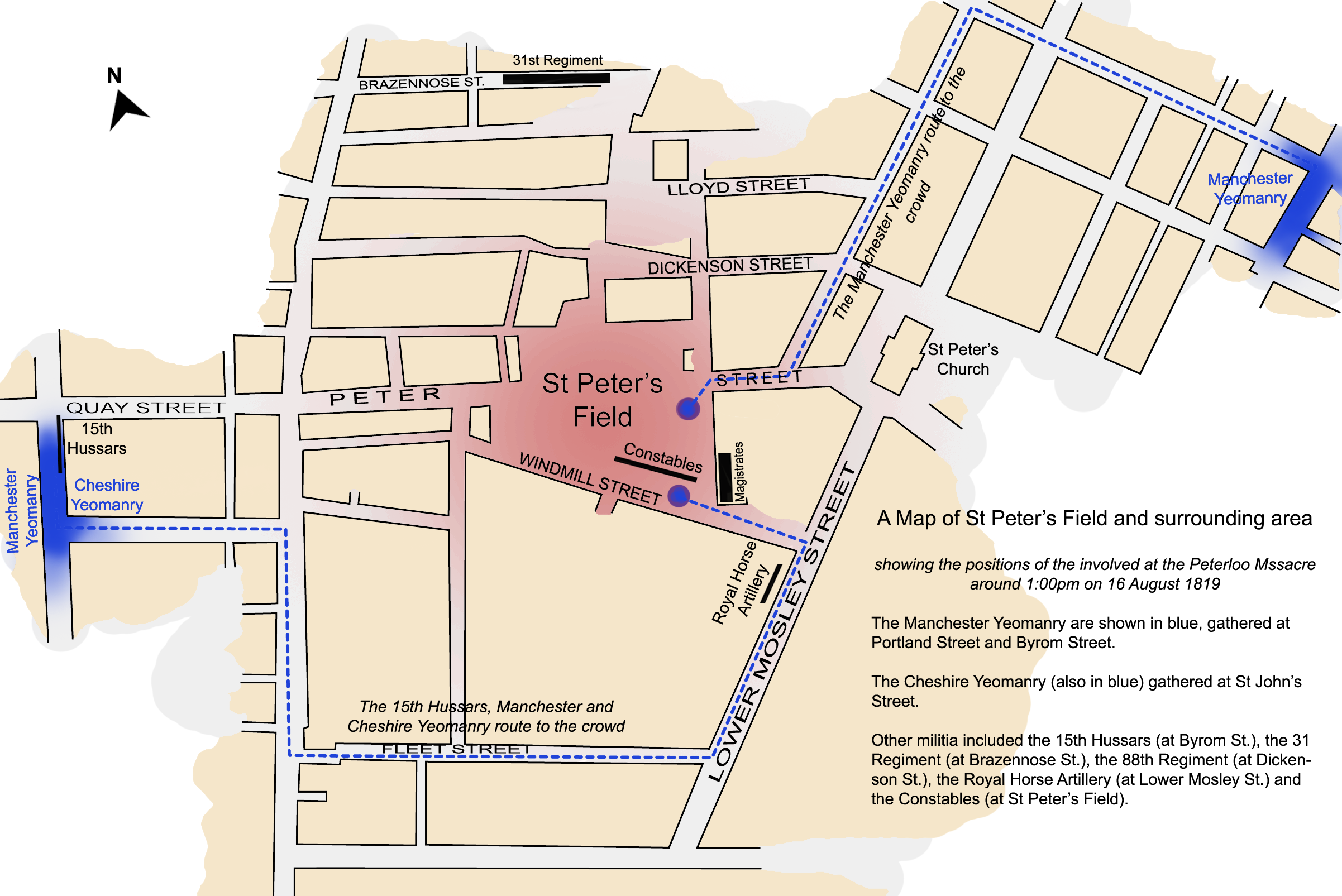
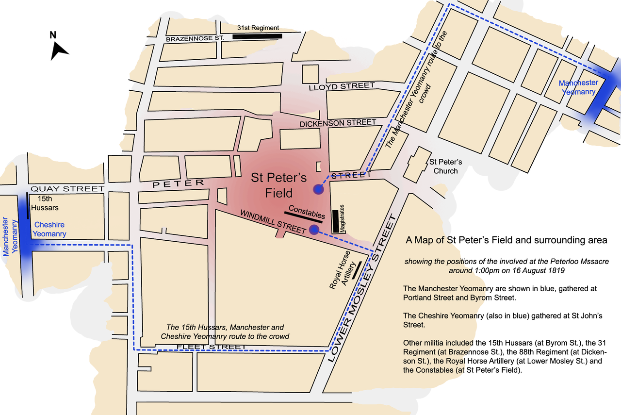
Protesters Manchester & Cheshire Yeomanry |
|||||||||
| Päiväys | ||||||||||
| Lähde | Oma teos by Jhamez84 | |||||||||
| Tekijä | ||||||||||
| Ajan ja paikan tiedot | ||||||||||
| Kuvattu ajankohta | 16. elokuuta 1819, 13:00 | |||||||||
| Kartan kuvaama paikka | St Peter's Square | |||||||||
| Karttapohjoinen |
 |
|||||||||
| Rajausalue |
|
|||||||||
| Georeferointi | ||||||||||
| Tiedot objektista | ||||||||||
| artwork-references | based on Reid, Robert (1989) The Peterloo Massacre, William Heinemann Ltd ISBN: 0434629014. | |||||||||
Lisenssi
Minä, tämän teoksen tekijänoikeuksien haltija, julkaisen täten tämän teoksen seuraavilla lisensseillä:

|
Voit kopioida, levittää ja/tai muuttaa tätä asiakirjaa GNU Free Documentation License -lisenssin version 1.2 tai minkä tahansa Free Software Foundationin julkaiseman myöhemmän version ehtojen alaisena; ei koske muuttumattomia kohtia, etukannen tekstejä eikä takakannen tekstejä. Kopio tästä lisenssistä on saatavilla osiossa GNU Free Documentation License. |
Tämä tiedosto on lisensoitu Creative Commons Nimeä 3.0 Ei sovitettu -lisenssillä.
- Voit:
- jakaa – kopioida, levittää ja esittää teosta
- remiksata – valmistaa muutettuja teoksia
- Seuraavilla ehdoilla:
- nimeäminen – Sinun on mainittava lähde asianmukaisesti, tarjottava linkki lisenssiin sekä merkittävä, mikäli olet tehnyt muutoksia. Voit tehdä yllä olevan millä tahansa kohtuullisella tavalla, mutta et siten, että annat ymmärtää lisenssinantajan suosittelevan sinua tai teoksen käyttöäsi.
Voit valita haluamasi lisenssin.
Tiedoston historia
Päiväystä napsauttamalla näet, millainen tiedosto oli kyseisellä hetkellä.
| Päiväys | Pienoiskuva | Koko | Käyttäjä | Kommentti | |
|---|---|---|---|---|---|
| nykyinen | 4. huhtikuuta 2008 kello 04.45 | | 2 403 × 1 605 (679 KiB) | Jza84 | {{Information |Description=A map of St Peter's Field, Manchester, England at the time of the Peterloo Massacre of 1819. This map, highlights the positions of those parties involved in the massacre as they were documented to have been at 1.00pm. |Source |
Tiedoston käyttö
Seuraava sivu käyttää tätä tiedostoa:
Tiedoston järjestelmänlaajuinen käyttö
Seuraavat muut wikit käyttävät tätä tiedostoa:
- Käyttö kohteessa az.wikipedia.org
- Käyttö kohteessa en.wikipedia.org
- Käyttö kohteessa es.wikipedia.org
- Käyttö kohteessa fr.wikipedia.org
- Käyttö kohteessa it.wikipedia.org
- Käyttö kohteessa ja.wikipedia.org
- Käyttö kohteessa tr.wikipedia.org
- Käyttö kohteessa www.wikidata.org
- Käyttö kohteessa zh.wikipedia.org