Tiedosto:MGRSgridSouthPole.png

Tämän esikatselun koko: 798 × 600 kuvapistettä. Muut resoluutiot: 320 × 240 kuvapistettä | 639 × 480 kuvapistettä | 1 022 × 768 kuvapistettä | 1 280 × 962 kuvapistettä | 1 469 × 1 104 kuvapistettä.
Alkuperäinen tiedosto (1 469 × 1 104 kuvapistettä, 1 023 KiB, MIME-tyyppi: image/png)
| Tämä tiedosto on tiedostotietokanta Wikimedia Commonsista. Tiedot kuvaussivulta näkyvät alla. |  |
Tiedoston kuvaussivu Commonsissa |
Yhteenveto
| Kuvaus |
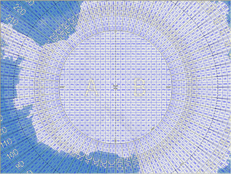
English: Map of the Military Grid Reference System (MGRS) around the South Pole, with the AA lettering scheme for the 100 km squares north of 80°S. |
| Päiväys | |
| Lähde |
English: Mikael R made the MGRS grid in Carmenta Engine, with a background map from Natural Earth by Tom Patterson, US National Park Service. |
| Tekijä | Mikael Rittri (MikaelR) |
Lisenssi
Tämä tiedosto on lisensoitu Creative Commons Nimeä-JaaSamoin 3.0 Ei sovitettu -lisenssillä.
- Voit:
- jakaa – kopioida, levittää ja esittää teosta
- remiksata – valmistaa muutettuja teoksia
- Seuraavilla ehdoilla:
- nimeäminen – Sinun on mainittava lähde asianmukaisesti, tarjottava linkki lisenssiin sekä merkittävä, mikäli olet tehnyt muutoksia. Voit tehdä yllä olevan millä tahansa kohtuullisella tavalla, mutta et siten, että annat ymmärtää lisenssinantajan suosittelevan sinua tai teoksen käyttöäsi.
- jaa samoin – Jos muutat tai perustat tähän työhön, voit jakaa tuloksena syntyvää työtä vain tällä tai tämän kaltaisella lisenssillä.
Tiedoston historia
Päiväystä napsauttamalla näet, millainen tiedosto oli kyseisellä hetkellä.
| Päiväys | Pienoiskuva | Koko | Käyttäjä | Kommentti | |
|---|---|---|---|---|---|
| nykyinen | 21. marraskuuta 2007 kello 14.59 | | 1 469 × 1 104 (1 023 KiB) | MikaelR | {{Information |Description={{en|Map of the Military Grid Reference System (MGRS) around the South Pole, with the AA lettering scheme for the 100 km squares north of 80°S.}} |Source={{en|Mikael R made the MGRS grid in SpatialAce of Carmenta, with a backgr |
Tiedoston käyttö
Seuraava sivu käyttää tätä tiedostoa:
Tiedoston järjestelmänlaajuinen käyttö
Seuraavat muut wikit käyttävät tätä tiedostoa:
- Käyttö kohteessa en.wikipedia.org
- Käyttö kohteessa uk.wikipedia.org
- Käyttö kohteessa zh.wikipedia.org