Tiedosto:Liberty Island Site Plan - Statue of Liberty, Liberty Island, Manhattan, New York, New York County, NY HAER NY,31-NEYO,89- (sheet 1 of 36).tif

Tämän JPG-esikatselun koko koskien TIF-tiedostoa: 800 × 533 kuvapistettä. Muut resoluutiot: 320 × 213 kuvapistettä | 640 × 427 kuvapistettä | 1 024 × 683 kuvapistettä | 1 280 × 853 kuvapistettä | 2 560 × 1 707 kuvapistettä | 14 400 × 9 600 kuvapistettä.
Alkuperäinen tiedosto (14 400 × 9 600 kuvapistettä, 1,67 MiB, MIME-tyyppi: image/tiff)
| Tämä tiedosto on tiedostotietokanta Wikimedia Commonsista. Tiedot kuvaussivulta näkyvät alla. |  |
Tiedoston kuvaussivu Commonsissa |
Yhteenveto
| Varoitus | Joillakin selaimilla saattaa olla ongelmia näyttää tämä kuva täydellä resoluutiolla: Kuvalla on epätavallisen suuri määrä pikseleitä ja se ei välttämättä lataudu tai selaimesi kaatuu sen takia. |
|---|
| Liberty Island Site Plan - Statue of Liberty, Liberty Island, Manhattan, New York, New York County, NY | ||||
|---|---|---|---|---|
| Valokuvaaja |
Patel, Ananta, creator |
|||
| Otsikko |
Liberty Island Site Plan - Statue of Liberty, Liberty Island, Manhattan, New York, New York County, NY |
|||
| Kuvan esittämä paikka | New York; New York County; New York | |||
| Päiväys | 2011 | |||
| Mitat | 24 x 36 in. (D size) | |||
| Nykyinen sijainti |
Library of Congress Prints and Photographs Division Washington, D.C. 20540 USA http://hdl.loc.gov/loc.pnp/pp.print |
|||
| Tunniste |
HAER NY,31-NEYO,89- (sheet 1 of 36) |
|||
| Kiitokset |
|
|||
| Lisätietoja |
|
|||
| Lähteet |
Related names:
|
|||
| Lähde | https://www.loc.gov/pictures/item/ny1251.sheet.00006a | |||
| Käyttöoikeus (Tämän tiedoston uudelleenkäyttö) |
|
|||
| Muut versiot |
.png) .png) .png) .png) .png) .png) .png) .png) .png) .png) .png) .png) .png) .png) .png) .png) .png) .png) .png) .png) |
|||

| Kohteen sijainti | | Tämä ja muut kuvat kartalla: OpenStreetMap |
|---|
Tiedoston historia
Päiväystä napsauttamalla näet, millainen tiedosto oli kyseisellä hetkellä.
| Päiväys | Pienoiskuva | Koko | Käyttäjä | Kommentti | |
|---|---|---|---|---|---|
| nykyinen | 29. heinäkuuta 2014 kello 19.04 | 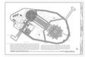 | 14 400 × 9 600 (1,67 MiB) | Fæ | GWToolset: Creating mediafile for Fæ. HABS 24 July 2014 (2301:2600) |
Tiedoston käyttö
Seuraava sivu käyttää tätä tiedostoa: