Tiedosto:Khazar1.png
Tarkempaa kuvaa ei ole saatavilla.
Khazar1.png (498 × 448 kuvapistettä, 12 KiB, MIME-tyyppi: image/png)
| Tämä tiedosto on tiedostotietokanta Wikimedia Commonsista. Tiedot kuvaussivulta näkyvät alla. |  |
Tiedoston kuvaussivu Commonsissa |
Yhteenveto
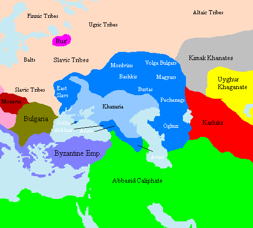
Map showing approximate extent of the w:Khazar w:Khaganate (light blue) and its sphere of influence (dark blue) at its height, c. 820 CE. Polity names in white indicate client-states or tribes of Khazaria.
The source is one of the GFDL World Maps on [1].
Lisenssi
Taken from en:File:Khazar1.png, created by en.wikipedia.org user Briangotts, who released it under the GPL.
| Tämä tiedosto on lisensoitu Creative Commons Nimeä-JaaSamoin 3.0 Ei sovitettu -lisenssillä. Teokseen sovelletaan englanninkielisen Wikipedian vastuuvapauslauseketta. | ||
| ||
| Lisensointimerkintä lisätiin tähän tiedostoon osana GFDL-lisensointipäivitystä. |

|
Voit kopioida, levittää ja/tai muuttaa tätä asiakirjaa GNU Free Documentation License -lisenssin version 1.2 tai minkä tahansa Free Software Foundationin julkaiseman myöhemmän version ehtojen alaisena; ei koske muuttumattomia kohtia, etukannen tekstejä eikä takakannen tekstejä. Kopio tästä lisenssistä on saatavilla osiossa GNU Free Documentation License. Teokseen sovelletaan englanninkielisen Wikipedian vastuuvapauslauseketta. |
Tiedoston historia
Päiväystä napsauttamalla näet, millainen tiedosto oli kyseisellä hetkellä.
| Päiväys | Pienoiskuva | Koko | Käyttäjä | Kommentti | |
|---|---|---|---|---|---|
| nykyinen | 16. kesäkuuta 2022 kello 18.29 | | 498 × 448 (12 KiB) | Web3Punkt11 | restore white font labels because "Polity names in white indicate client-states or tribes of Khazaria." --User:Jrohr (originator) |
| 11. lokakuuta 2012 kello 13.44 |  | 498 × 448 (19 KiB) | MicBy67 | Hintergrundfarben angepasst | |
| 17. tammikuuta 2006 kello 12.10 |  | 498 × 448 (17 KiB) | Jrohr | == Summary == Map showing approximate extent of the w:Khazar w:Khaganate (light blue) and its sphere of influence (dark blue) at its height, c. 820 CE. Polity names in white indicate client-states or tribes of Khazaria. [[Category:Historical map |
Tiedoston käyttö
Seuraava sivu käyttää tätä tiedostoa:
Tiedoston järjestelmänlaajuinen käyttö
Seuraavat muut wikit käyttävät tätä tiedostoa:
- Käyttö kohteessa de.wikipedia.org
- Käyttö kohteessa en.wikipedia.org
- Käyttö kohteessa fr.wikipedia.org
- Käyttö kohteessa he.wikipedia.org
- Käyttö kohteessa lt.wikipedia.org
- Käyttö kohteessa nl.wikipedia.org
- Käyttö kohteessa pl.wikipedia.org
- Käyttö kohteessa ru.wikipedia.org
- Käyttö kohteessa tt.wikipedia.org