Tiedosto:Karte Nordostgrönland Koch 1911.png

Alkuperäinen tiedosto (1 196 × 1 542 kuvapistettä, 1,46 MiB, MIME-tyyppi: image/png)
| Tämä tiedosto on tiedostotietokanta Wikimedia Commonsista. Tiedot kuvaussivulta näkyvät alla. |  |
Tiedoston kuvaussivu Commonsissa |
Yhteenveto
| Kuvaus |
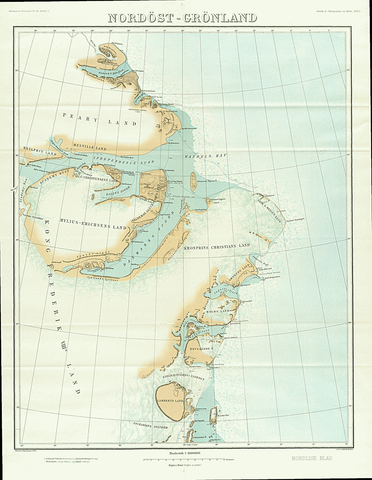
English: Map of North East Greenland by Johan Peter Koch as surveyed during the Danmark Expedition 1906-1908
Deutsch: Johan Peter Kochs Karte Nordostgrönlands, angefertigt nach der Landvermessung durch die Danmark-Expedition 1906-1908 |
| Päiväys | |
| Lähde | J. P. Koch: Danmark-Ekspeditionens Kort, Geografisk Tidsskrift, 21 ,1911–1912, p. 167–177 ([1], p. 4 of 18) |
| Tekijä | Johan Peter Koch (1870-1928) |
Lisenssi
|
Tämä teos on public domainissa lähes maailmanlaajuisesti, koska tekijän kuolemasta on kulunut yli 70 vuotta.
| |
| Tämä teos on vapaa tunnetuista tekijänoikeuslain mukaisista rajoituksista, mukaanlukien lähioikeuksista. | |
Tiedoston historia
Päiväystä napsauttamalla näet, millainen tiedosto oli kyseisellä hetkellä.
| Päiväys | Pienoiskuva | Koko | Käyttäjä | Kommentti | |
|---|---|---|---|---|---|
| nykyinen | 20. tammikuuta 2019 kello 14.21 | | 1 196 × 1 542 (1,46 MiB) | Ratzer | bessere Auflösung? (Test) |
| 3. kesäkuuta 2015 kello 23.27 |  | 990 × 1 290 (677 KiB) | Cmdrjameson | Compressed with pngout. Reduced by 823kB (54% decrease). | |
| 13. kesäkuuta 2014 kello 12.24 |  | 990 × 1 290 (1,47 MiB) | Dreizung | {{Information |Description ={{en|1=Map of North East Greenland by Johan Peter Koch as surveyed during the Danmark Expedition 1906-1908}} {{de|1=Johan Peter Kochs Karte Nordostgrönlands, angefertigt nach der Landvermessung durch die Danmark-Expediti... |
Tiedoston käyttö
Seuraava sivu käyttää tätä tiedostoa:
Tiedoston järjestelmänlaajuinen käyttö
Seuraavat muut wikit käyttävät tätä tiedostoa:
- Käyttö kohteessa ceb.wikipedia.org
- Käyttö kohteessa da.wikipedia.org
- Käyttö kohteessa de.wikipedia.org
- Käyttö kohteessa en.wikipedia.org
- Danmark Fjord
- Hagen Fjord
- Frederick E. Hyde Fjord
- Zachariae Isstrom
- Lynn Island
- Princess Thyra Island
- Holm Land
- Ingolf Fjord
- Academy Glacier (Greenland)
- Lambert Land
- Cape Bridgman
- Mylius-Erichsen Land
- Mallemuk Mountain
- Roosevelt Range
- Daly Range
- Flade Isblink
- Amdrup Land
- Antarctic Bay (Greenland)
- Wyckoff Land
- Cape Clarence Wyckoff
- Herluf Trolle Land
- Käyttö kohteessa es.wikipedia.org
- Käyttö kohteessa fa.wikipedia.org
- Käyttö kohteessa fr.wikipedia.org
- Käyttö kohteessa it.wikipedia.org
- Käyttö kohteessa nl.wikipedia.org
- Käyttö kohteessa sv.wikipedia.org
- Käyttö kohteessa www.wikidata.org