Tiedosto:ISS009-E-7622- Zambezi river near Mongu.jpg

Tämän esikatselun koko: 800 × 527 kuvapistettä. Muut resoluutiot: 320 × 211 kuvapistettä | 640 × 422 kuvapistettä | 1 024 × 675 kuvapistettä | 1 280 × 843 kuvapistettä | 3 032 × 1 998 kuvapistettä.
Alkuperäinen tiedosto (3 032 × 1 998 kuvapistettä, 4,71 MiB, MIME-tyyppi: image/jpeg)
| Tämä tiedosto on tiedostotietokanta Wikimedia Commonsista. Tiedot kuvaussivulta näkyvät alla. |  |
Tiedoston kuvaussivu Commonsissa |
Yhteenveto
| Kuvaus |
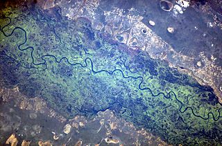
English: The Zambezi river and its floodplain, seen from the international space station. |
| Päiväys | Kuvattu 16. toukokuuta 2004, 14:23:54 UTC |
| Lähde | http://eol.jsc.nasa.gov/scripts/sseop/photo.pl?mission=ISS009&roll=E&frame=7622 + Oma teos |
| Tekijä | NASA |
| Kameran sijainti | | Tämä ja muut kuvat kartalla: OpenStreetMap |
|---|
This image or video was catalogued by Johnson Space Center of the United States National Aeronautics and Space Administration (NASA) under Photo ID: ISS009-E-07622. This tag does not indicate the copyright status of the attached work. A normal copyright tag is still required. See Commons:Licensing. Other languages:
|
Lisenssi
This file is in the public domain in the United States because it was created by the Image Science & Analysis Laboratory, of the NASA Johnson Space Center. NASA copyright policy states that "NASA material is not protected by copyright unless noted". (NASA media use guidelines or Conditions of Use of Astronaut Photographs).
Photo source: ISS009-E-07622.
|
Alkuperäinen tallennusloki
Siirretty projektista en.wikipedia Commonsiin työkalulla FtCG.
Alkuperäinen kuvaussivu oli täällä. Käyttäjätunnukset alla viittaavat kohteeseen en.wikipedia.
| Date/Time | Dimensions | User | Comment |
|---|---|---|---|
| 09:28, 1 June 2010 | 3,032 × 1,998 (4,934,566 bytes) | w:en:Originalwana (keskustelu | muokkaukset) | (higher res, changed white balance ) |
| 10:50, 10 August 2005 | 639 × 435 (37,968 bytes) | w:en:Worldtraveller (keskustelu | muokkaukset) | (The Zambezi river and its floodplain, seen from the international space station. From http://eol.jsc.nasa.gov {{PD-USGov-NASA}}) |
Tiedoston historia
Päiväystä napsauttamalla näet, millainen tiedosto oli kyseisellä hetkellä.
| Päiväys | Pienoiskuva | Koko | Käyttäjä | Kommentti | |
|---|---|---|---|---|---|
| nykyinen | 27. helmikuuta 2012 kello 09.26 | | 3 032 × 1 998 (4,71 MiB) | Bulwersator | Transferred from en.wikipedia: see original upload log above |
Tiedoston käyttö
Seuraava sivu käyttää tätä tiedostoa:
Tiedoston järjestelmänlaajuinen käyttö
Seuraavat muut wikit käyttävät tätä tiedostoa: