Tiedosto:Hurricane claudette july 15 2003.jpg

Alkuperäinen tiedosto (5 345 × 5 345 kuvapistettä, 20,23 MiB, MIME-tyyppi: image/jpeg)
| Tämä tiedosto on tiedostotietokanta Wikimedia Commonsista. Tiedot kuvaussivulta näkyvät alla. |  |
Tiedoston kuvaussivu Commonsissa |
Yhteenveto
| Kuvaus |
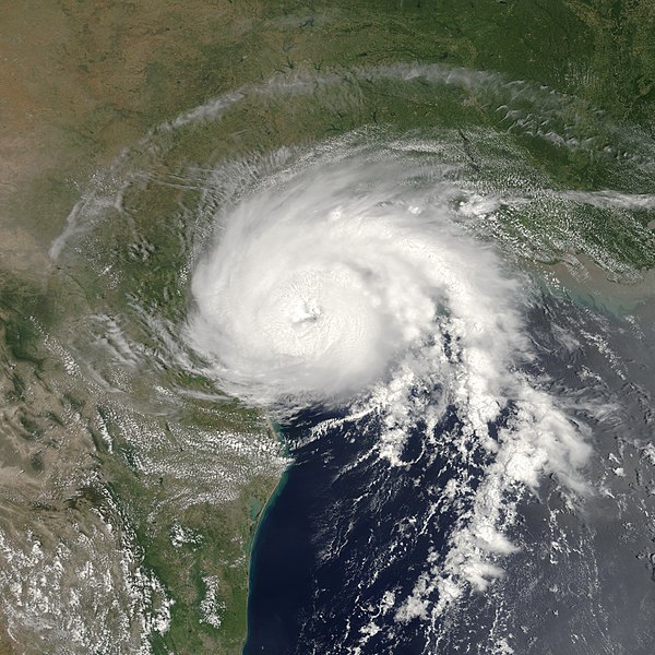
On July 15, 2003 at 12:55 EDT, the Moderate Resolution Imaging Spectroradiometer (MODIS) instrument onboard NASA’s Terra satellite captured this bird’s-eye view of Hurricane Claudette making landfall at Matagorda Bay on the middle Texas coast. At the time of this image Claudette was packing maximum sustained winds of 80 mph with slightly higher gusts, classifying the storm as a Category 1 hurricane on the Saffir-Simpson scale. Claudette is expected to dump as much as 10 inches of rain in portions of Texas and Louisiana and produce storm surge flooding of 4 to 6 feet above normal tide levels. As Claudette moves inland, she will weaken rapidly, but will continue to dump copious amounts rain on tonight (Tuesday) and tomorrow. This image was cropped from an earlier version. |
|||||
| Päiväys | ||||||
| Lähde | http://visibleearth.nasa.gov/view_rec.php?id=5509 | |||||
| Tekijä | Jacques Descloitres, MODIS Rapid Response Team, NASA/GSFC | |||||
| Käyttöoikeus (Tämän tiedoston uudelleenkäyttö) |
|
|||||
| Muut versiot | Image:Hurricane Claudette 15 july 2003 1655Z.jpg |

Tiedoston historia
Päiväystä napsauttamalla näet, millainen tiedosto oli kyseisellä hetkellä.
| Päiväys | Pienoiskuva | Koko | Käyttäjä | Kommentti | |
|---|---|---|---|---|---|
| nykyinen | 24. kesäkuuta 2018 kello 07.05 | | 5 345 × 5 345 (20,23 MiB) | TheAustinMan | Restore original curve correction and recenter |
| 24. kesäkuuta 2018 kello 05.47 |  | 4 400 × 4 400 (3,16 MiB) | TheAustinMan | Previous version was already at native resolution and corrected for excess radiance | |
| 4. toukokuuta 2018 kello 00.34 |  | 1 240 × 1 620 (437 KiB) | CooperScience | Geo-rectify and centering | |
| 1. maaliskuuta 2006 kello 00.09 |  | 4 400 × 4 400 (3,16 MiB) | Good kitty | == Summary == http://visibleearth.nasa.gov/view_detail.php?id=5509 NASA image courtesy Jeff Schmaltz, MODIS Rapid Response Team, Goddard Space Flight Center |
Tiedoston käyttö
Seuraava sivu käyttää tätä tiedostoa:
Tiedoston järjestelmänlaajuinen käyttö
Seuraavat muut wikit käyttävät tätä tiedostoa:
- Käyttö kohteessa ar.wikipedia.org
- Käyttö kohteessa de.wikipedia.org
- Käyttö kohteessa en.wikipedia.org
- 2003 Atlantic hurricane season
- Portal:Tropical cyclones
- Hurricane Claudette (2003)
- Portal:Tropical cyclones/Featured article/Hurricane Claudette (2003)
- Portal:Latin America/Featured article list
- Portal:Latin America/Featured article/Day 10
- Portal:Tropical cyclones/Anniversaries/July
- Portal:Tropical cyclones/Anniversaries/July/15
- Portal:Geography/Featured article/December, 2008
- Timeline of the 2003 Atlantic hurricane season
- Portal:Geography/Featured article/archive/2008
- Wikipedia:Today's featured article/November 2014
- Wikipedia:Today's featured article/November 16, 2014
- Wikipedia:Main Page history/2014 November 16
- Käyttö kohteessa es.wikipedia.org
- Käyttö kohteessa fr.wikipedia.org
- Käyttö kohteessa ja.wikipedia.org
- Käyttö kohteessa pt.wikipedia.org
- Käyttö kohteessa simple.wikipedia.org
- Käyttö kohteessa vi.wikipedia.org
- Käyttö kohteessa www.wikidata.org
- Käyttö kohteessa zh.wikipedia.org
- Portal:美國/特色條目
- 2003年大西洋飓风季
- Wikipedia:典范条目/2014年3月
- Wikipedia:优良条目/2014年5月
- 2003年飓风克劳德特
- Talk:2003年飓风克劳德特
- Wikipedia:优良条目/2014年5月20日
- Wikipedia:优良条目/2003年飓风克劳德特
- Wikipedia:典范条目/2014年3月31日
- Portal:美國/特色條目/97
- Wikipedia:典范条目/2003年飓风克劳德特
- 2003年大西洋飓风季时间轴
- 2003年大西洋飓风季的风暴
- Wikipedia:典范条目/2015年10月
- Wikipedia:典范条目/2015年10月24日
- Wikipedia:典范条目/2018年1月
- Wikipedia:典范条目/2018年1月4日
- Wikipedia:典范条目/2021年4月
- Wikipedia:典范条目/2021年4月10日