Tiedosto:Eifel - Deutsche Mittelgebirge, Serie A-de.png
Alkuperäinen tiedosto (2 500 × 2 600 kuvapistettä, 9,83 MiB, MIME-tyyppi: image/png)
| Tämä tiedosto on tiedostotietokanta Wikimedia Commonsista. Tiedot kuvaussivulta näkyvät alla. |  |
Tiedoston kuvaussivu Commonsissa |
Yhteenveto
| Kuvaus |
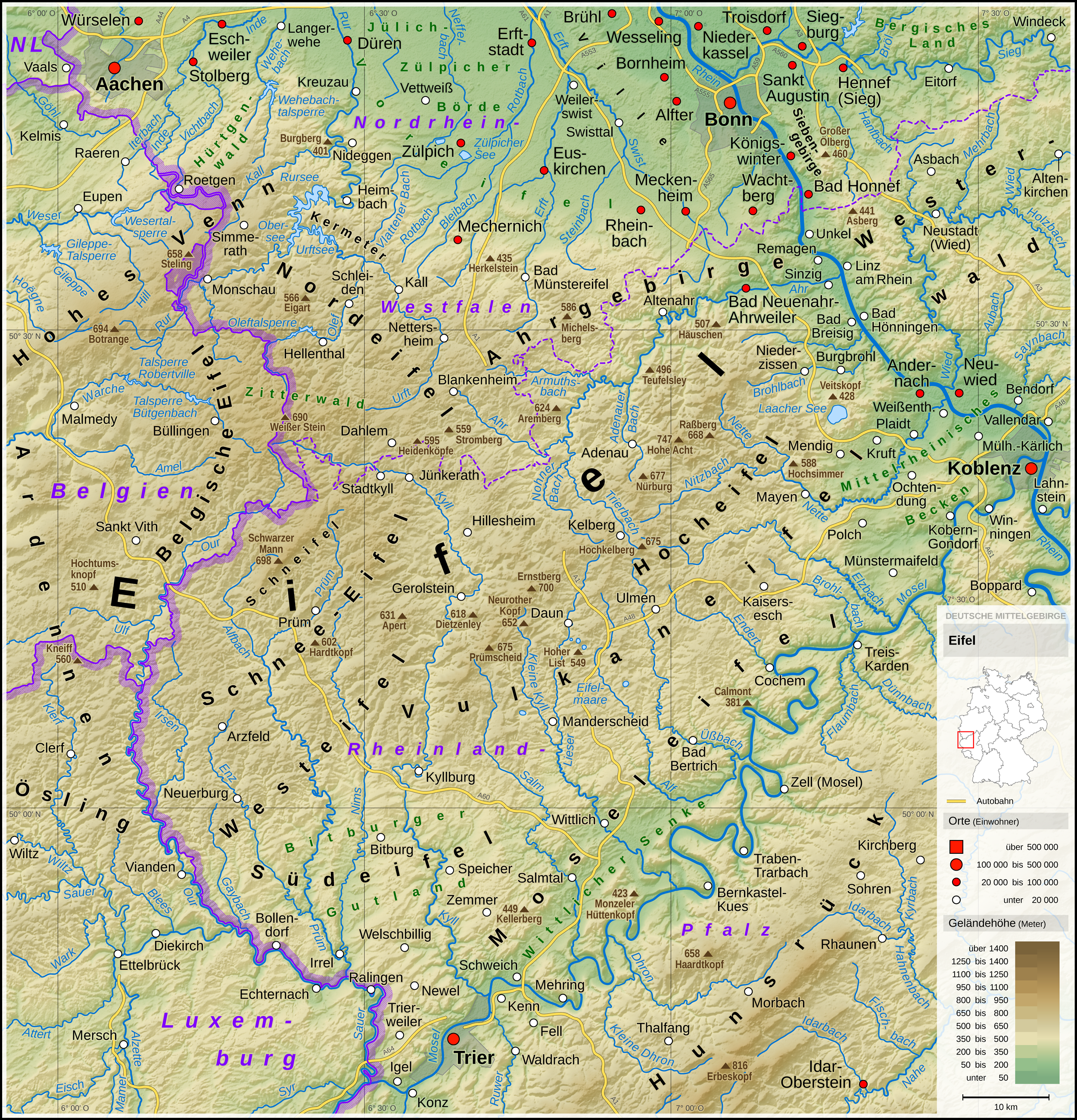
English: Topographic map of the Eifel
Deutsch: Topografische Karte der Eifel |
||||||||||||||||||
| Päiväys | |||||||||||||||||||
| Lähde |
Own work using: |
||||||||||||||||||
| Tekijä | Thoroe | ||||||||||||||||||
| Muut versiot |
 Topographic maps of German low mountain ranges (A series)
This map series aims to show the major low mountain ranges of Germany in a uniform design. All maps are created on the same scale, and the background reliefs base upon the same color scheme. The reliefs are also available as separate files. You can find the making-of one of the maps in the German language Wikipedia (German only).
|
||||||||||||||||||


_-_Deutsche_Mittelgebirge,_Serie_A-de.png)
_-_Deutsche_Mittelgebirge,_Serie_A-de.png)
_-_Deutsche_Mittelgebirge,_Serie_A-de.png)
_-_Deutsche_Mittelgebirge,_Serie_A-de.png)
_-_Deutsche_Mittelgebirge,_Serie_A-de.png)
_-_Deutsche_Mittelgebirge,_Serie_A-de.png)
_-_Deutsche_Mittelgebirge,_Serie_A-de.png)
_-_Deutsche_Mittelgebirge,_Serie_A-de.png)
_-_Deutsche_Mittelgebirge,_Serie_A-de.png)
_-_Deutsche_Mittelgebirge,_Serie_A-de.png)
_-_Deutsche_Mittelgebirge,_Serie_A-de.png)
_-_Deutsche_Mittelgebirge,_Serie_A-de.png)
_-_Deutsche_Mittelgebirge,_Serie_A-de.png)
_-_Deutsche_Mittelgebirge,_Serie_A-de.png)
_-_Deutsche_Mittelgebirge,_Serie_A-de.png)
_-_Deutsche_Mittelgebirge,_Serie_A-de.png)
_-_Deutsche_Mittelgebirge,_Serie_A-de.png)
_-_Deutsche_Mittelgebirge,_Serie_A-de.png)
_-_Deutsche_Mittelgebirge,_Serie_A-de.png)
_-_Deutsche_Mittelgebirge,_Serie_A-de.png)
_-_Deutsche_Mittelgebirge,_Serie_A-de.png)
_-_Deutsche_Mittelgebirge,_Serie_A-de.png)
_-_Deutsche_Mittelgebirge,_Serie_A-de.png)
_-_Deutsche_Mittelgebirge,_Serie_A-de.png)
_-_Deutsche_Mittelgebirge,_Serie_A-de.png)
_-_Deutsche_Mittelgebirge,_Serie_A-de.png)
_-_Deutsche_Mittelgebirge,_Serie_A-de.png)
_-_Deutsche_Mittelgebirge,_Serie_A-de.png)
_-_Deutsche_Mittelgebirge,_Serie_A-de.png)
_-_Deutsche_Mittelgebirge,_Serie_A-de.png)
_-_Deutsche_Mittelgebirge,_Serie_A-de.png)
_-_Deutsche_Mittelgebirge,_Serie_A-de.png)
| This work contains information from OpenStreetMap, which is made available under the Open Database License (ODbL).
The ODbL does not require any particular license for maps produced from ODbL data. Prior to 1 August 2020, map tiles produced by the OpenStreetMap Foundation were licensed under the CC-BY-SA-2.0 license. Maps produced by other people may be subject to other licences. |

|
Saksankielisen Wikipedian projekti Kartenwerkstatt on parantanut tätä karttaa. Myös sinä voit ehdottaa jotakin karttaa parannettavaksi.
|
Lisenssi
- Voit:
- jakaa – kopioida, levittää ja esittää teosta
- remiksata – valmistaa muutettuja teoksia
- Seuraavilla ehdoilla:
- nimeäminen – Sinun on mainittava lähde asianmukaisesti, tarjottava linkki lisenssiin sekä merkittävä, mikäli olet tehnyt muutoksia. Voit tehdä yllä olevan millä tahansa kohtuullisella tavalla, mutta et siten, että annat ymmärtää lisenssinantajan suosittelevan sinua tai teoksen käyttöäsi.
- jaa samoin – Jos muutat tai perustat tähän työhön, voit jakaa tuloksena syntyvää työtä vain tällä tai tämän kaltaisella lisenssillä.
| Annotations | This image is annotated: View the annotations at Commons |
Tiedoston historia
Päiväystä napsauttamalla näet, millainen tiedosto oli kyseisellä hetkellä.
| Päiväys | Pienoiskuva | Koko | Käyttäjä | Kommentti | |
|---|---|---|---|---|---|
| nykyinen | 13. toukokuuta 2017 kello 13.53 | | 2 500 × 2 600 (9,83 MiB) | Thoroe | Brohlbach (Mosel) korr. |
| 11. toukokuuta 2017 kello 02.05 |  | 2 500 × 2 600 (9,82 MiB) | Thoroe | + Stadtkyll | |
| 7. toukokuuta 2017 kello 16.56 |  | 2 500 × 2 600 (9,82 MiB) | Thoroe | 1st revision | |
| 4. toukokuuta 2017 kello 23.37 |  | 2 500 × 2 600 (9,82 MiB) | Thoroe | {{Information |Description ={{en|1=Topographic map of the Eifel}} {{de|1=Topografische Karte der Eifel}} |Source ={{Own using}} *[http://gmt.soest.hawaii.edu Generic Mapping Tools (GMT)] with [http://dds.cr.usgs.g... |
Tiedoston käyttö
Seuraava sivu käyttää tätä tiedostoa:
Tiedoston järjestelmänlaajuinen käyttö
Seuraavat muut wikit käyttävät tätä tiedostoa:
- Käyttö kohteessa arz.wikipedia.org
- Käyttö kohteessa bn.wikipedia.org
- Käyttö kohteessa ca.wikipedia.org
- Käyttö kohteessa da.wikipedia.org
- Käyttö kohteessa de.wikipedia.org
- Eifel
- Vulkaneifel
- Wittlicher Senke
- Winterspelt (Andersch)
- Schneifel
- Östliche Hocheifel
- Ahrgebirge
- Rureifel
- Nordeifel
- Südeifel
- Zitterwald
- Portal:Eifel
- Kermeter
- Hürtgenwald (Forst)
- Wikipedia:Kartenwerkstatt/Kartenwünsche
- Moseleifel
- Liste von Bergen und Erhebungen der Eifel
- Voreifel
- Liste der naturräumlichen Einheiten in Rheinland-Pfalz
- Benutzer:Thoroe
- Bitburger Gutland
- Wikipedia:Kartenwerkstatt/Archiv/2017-05
- Prümscheid (Naturraum)
- Benutzer:Thoroe/Making of Thüringer Wald
- Käyttö kohteessa de.wiktionary.org
- Käyttö kohteessa el.wikipedia.org
- Käyttö kohteessa en.wikipedia.org
- Käyttö kohteessa en.wikivoyage.org
- Käyttö kohteessa eo.wikipedia.org
- Käyttö kohteessa es.wikipedia.org
- Käyttö kohteessa et.wikipedia.org
- Käyttö kohteessa fa.wikipedia.org
- Käyttö kohteessa frr.wikipedia.org
- Käyttö kohteessa fr.wikipedia.org
- Käyttö kohteessa fr.wiktionary.org
Näytä lisää tämän tiedoston järjestelmänlaajuista käyttöä.