Tiedosto:Edinburgh tramway map.svg

Tämän PNG-esikatselun koko koskien SVG-tiedostoa: 800 × 259 kuvapistettä. Muut resoluutiot: 320 × 104 kuvapistettä | 640 × 207 kuvapistettä | 1 024 × 331 kuvapistettä | 1 280 × 414 kuvapistettä | 2 560 × 828 kuvapistettä | 850 × 275 kuvapistettä.
Alkuperäinen tiedosto (SVG-tiedosto; oletustarkkuus 850 × 275 kuvapistettä; tiedostokoko 202 KiB)
| Tämä tiedosto on tiedostotietokanta Wikimedia Commonsista. Tiedot kuvaussivulta näkyvät alla. |  |
Tiedoston kuvaussivu Commonsissa |
Yhteenveto
| Kuvaus |
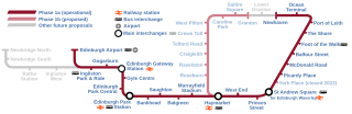
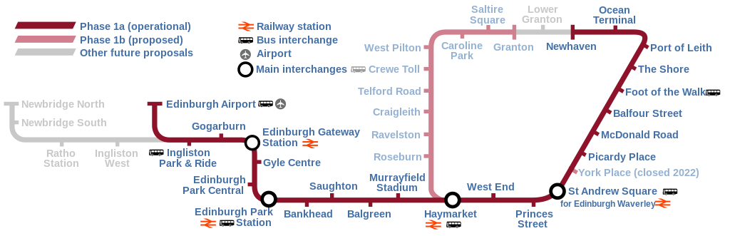
English: Map of the Edinburgh Trams system, showing the as built line (opened May 2014) alongside the various proposed lines that were ultimately abandoned or postponed indefinitely. |
| Päiväys | |
| Lähde | Oma teos |
| Tekijä | DavidArthur |
Lisenssi
Minä, tämän teoksen tekijänoikeuksien haltija, julkaisen täten tämän teoksen seuraavilla lisensseillä:

|
Voit kopioida, levittää ja/tai muuttaa tätä asiakirjaa GNU Free Documentation License -lisenssin version 1.2 tai minkä tahansa Free Software Foundationin julkaiseman myöhemmän version ehtojen alaisena; ei koske muuttumattomia kohtia, etukannen tekstejä eikä takakannen tekstejä. Kopio tästä lisenssistä on saatavilla osiossa GNU Free Documentation License. |
This file is licensed under the Creative Commons Attribution-Share Alike Attribution-Share Alike 4.0 International, 3.0 Unported, 2.5 Generic, 2.0 Generic and 1.0 Generic license.
- Voit:
- jakaa – kopioida, levittää ja esittää teosta
- remiksata – valmistaa muutettuja teoksia
- Seuraavilla ehdoilla:
- nimeäminen – Sinun on mainittava lähde asianmukaisesti, tarjottava linkki lisenssiin sekä merkittävä, mikäli olet tehnyt muutoksia. Voit tehdä yllä olevan millä tahansa kohtuullisella tavalla, mutta et siten, että annat ymmärtää lisenssinantajan suosittelevan sinua tai teoksen käyttöäsi.
- jaa samoin – Jos muutat tai perustat tähän työhön, voit jakaa tuloksena syntyvää työtä vain tällä tai tämän kaltaisella lisenssillä.
Voit valita haluamasi lisenssin.
Tiedoston historia
Päiväystä napsauttamalla näet, millainen tiedosto oli kyseisellä hetkellä.
| Päiväys | Pienoiskuva | Koko | Käyttäjä | Kommentti | |
|---|---|---|---|---|---|
| nykyinen | 17. kesäkuuta 2023 kello 17.58 | 850 × 275 (202 KiB) | Cnbrb | fix text embedding | |
| 17. kesäkuuta 2023 kello 17.30 | 850 × 275 (159 KiB) | Cnbrb | newhaven branch now operational; typographical and symbolic improvements | ||
| 11. toukokuuta 2020 kello 17.06 | 850 × 275 (88 KiB) | Angryskies | '''West End - Princes Street''' tram stop renamed to '''West End''' | ||
| 21. huhtikuuta 2020 kello 23.17 | 850 × 275 (90 KiB) | Angryskies | Updated details of line to Newhaven under construction. | ||
| 25. syyskuuta 2017 kello 16.06 | 850 × 275 (91 KiB) | Sladen | Inclusion of Edinburgh Gateway Station. | ||
| 28. syyskuuta 2013 kello 21.08 | 850 × 275 (88 KiB) | Sladen | Rename "Shandwick Place" to "West End – Princes Street" per {{cite news|url=http://www.edinburghnews.scotsman.com/news/transport/trams-shandwick-place-stop-renamed-princes-street-1-3106746|title=Trams: Shandwick Place stop renamed Princes Street|firs... | ||
| 9. helmikuuta 2013 kello 16.13 | 850 × 275 (88 KiB) | Sladen | Split Phase 1a (as built) from Phase 1a (not built) and show as dotted line. Reduce prominence of planned stations to focus on as-built section. Tweak key to include difference, and add "Airport" + pictogram for completeness. + remove errornous extr... | ||
| 9. helmikuuta 2013 kello 16.12 | 850 × 275 (88 KiB) | Sladen | Split Phase 1a (as built) from Phase 1a (not built) and show as dotted line. Reduce prominence of planned stations to focus on as-built section. Tweak key to include difference, and add "Airport" + pictogram for completeness. | ||
| 17. marraskuuta 2007 kello 20.48 | 850 × 275 (73 KiB) | DavidArthur | {{Information |Description={{en|20px|English A map of the proposed Edinburgh tramway.}} |Source=self-made |Date=17 November 2007 |Author= DavidArthur |Permission= |
Tiedoston käyttö
Seuraava sivu käyttää tätä tiedostoa:
Tiedoston järjestelmänlaajuinen käyttö
Seuraavat muut wikit käyttävät tätä tiedostoa:
- Käyttö kohteessa cs.wikipedia.org
- Käyttö kohteessa cy.wikipedia.org
- Käyttö kohteessa de.wikipedia.org
- Käyttö kohteessa en.wikipedia.org
- Käyttö kohteessa eo.wikipedia.org
- Käyttö kohteessa es.wikipedia.org
- Käyttö kohteessa fr.wikipedia.org
- Käyttö kohteessa he.wikipedia.org
- Käyttö kohteessa he.wikivoyage.org
- Käyttö kohteessa ja.wikipedia.org
- Käyttö kohteessa www.wikidata.org
- Käyttö kohteessa zh.wikipedia.org