Tiedosto:EasternVirginia1775.jpg

Alkuperäinen tiedosto (3 360 × 2 660 kuvapistettä, 2,84 MiB, MIME-tyyppi: image/jpeg)
| Tämä tiedosto on tiedostotietokanta Wikimedia Commonsista. Tiedot kuvaussivulta näkyvät alla. |  |
Tiedoston kuvaussivu Commonsissa |
Yhteenveto
| Kuvaus |
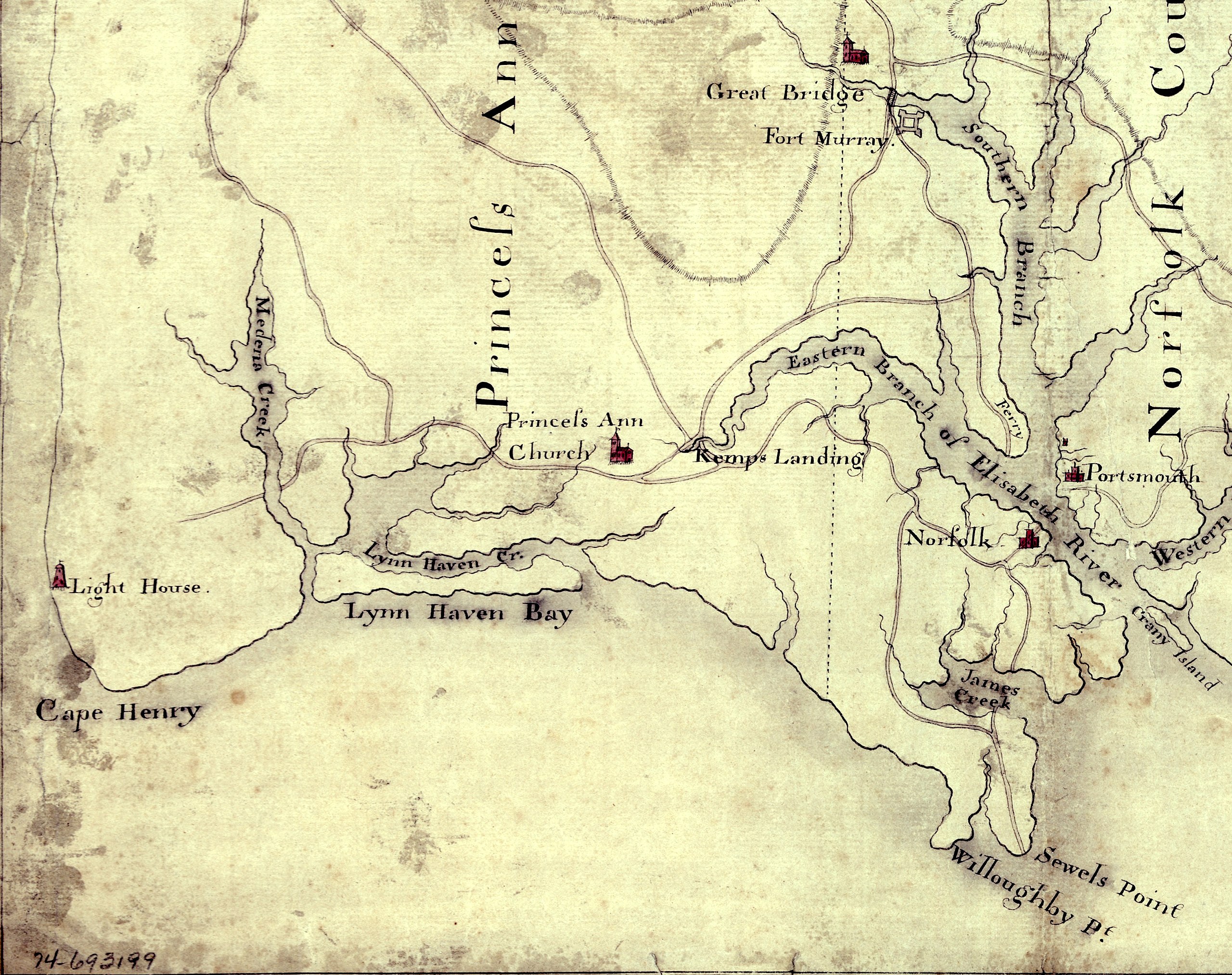
English: Detail of a 1780s manuscript map depicting the eastern coastal areas of Virginia, including portions of "Princess Anne" and Norfolk counties. The map is oriented with North to the bottom and South to the top. Part of the mouth of Chesapeake Bay is visible at the bottom of the map. The map depicts the sites of several military actions fought on land in the early days of the American Revolutionary War, including w:en:Battle of Kemp's Landing, w:en:Battle of Great Bridge, and the w:en:Burning of Norfolk, and the site of two sea battles of the war, the First and Second Battles of the Capes, the latter also known as w:en:Battle of the Chesapeake. |
||
| Päiväys | suunnilleen vuonna 1785 (Following a logistical and political delay of about 17 years, construction of the Cape Henry Lighthouse w:en:Cape Henry Light, depicted on the map, began about 1791 and was completed in 1792), LC claims "1779?;" Worldcat [1] claims "1785?". [See also "Early Map of First Colony’s Easternmost Landscape, Landmarks and Landowners"[2].]Hogident (keskustelu) 08:12, 26 January 2015 (UTC) | ||
| Lähde |
|
||
| Tekijä | Tuntematon | ||
| Käyttöoikeus (Tämän tiedoston uudelleenkäyttö) |
[NP: Request a change in file name, since it contains a contradiction in the date(s) of the map.] |

Lisenssi
|
Tämä teos on public domainissa lähes maailmanlaajuisesti, koska tekijän kuolemasta on kulunut yli 70 vuotta.
| |
| Tämä teos on vapaa tunnetuista tekijänoikeuslain mukaisista rajoituksista, mukaanlukien lähioikeuksista. | |
Tiedoston historia
Päiväystä napsauttamalla näet, millainen tiedosto oli kyseisellä hetkellä.
| Päiväys | Pienoiskuva | Koko | Käyttäjä | Kommentti | |
|---|---|---|---|---|---|
| nykyinen | 5. elokuuta 2010 kello 18.58 | | 3 360 × 2 660 (2,84 MiB) | Magicpiano | {{Information |Description={{en|Detail of a 1770s manuscript map depicting the eastern coastal areas of Virginia, including portions of Princess Ann and Norfolk Counties. The map is oriented with North to the bottom and South to the top. Part of the |
Tiedoston käyttö
Seuraava sivu käyttää tätä tiedostoa:
Tiedoston järjestelmänlaajuinen käyttö
Seuraavat muut wikit käyttävät tätä tiedostoa:
- Käyttö kohteessa ca.wikipedia.org
- Käyttö kohteessa en.wikipedia.org
- Käyttö kohteessa fr.wikipedia.org
- Käyttö kohteessa ja.wikipedia.org
- Käyttö kohteessa pt.wikipedia.org
- Käyttö kohteessa ru.wikipedia.org
- Käyttö kohteessa www.wikidata.org