Tiedosto:Distribution of Indigenous Peoples in the Americas.svg

Tämän PNG-esikatselun koko koskien SVG-tiedostoa: 600 × 600 kuvapistettä. Muut resoluutiot: 240 × 240 kuvapistettä | 480 × 480 kuvapistettä | 768 × 768 kuvapistettä | 1 024 × 1 024 kuvapistettä | 2 048 × 2 048 kuvapistettä | 3 200 × 3 200 kuvapistettä.
Alkuperäinen tiedosto (SVG-tiedosto; oletustarkkuus 3 200 × 3 200 kuvapistettä; tiedostokoko 2,13 MiB)
| Tämä tiedosto on tiedostotietokanta Wikimedia Commonsista. Tiedot kuvaussivulta näkyvät alla. |  |
Tiedoston kuvaussivu Commonsissa |
Yhteenveto
| Kuvaus |
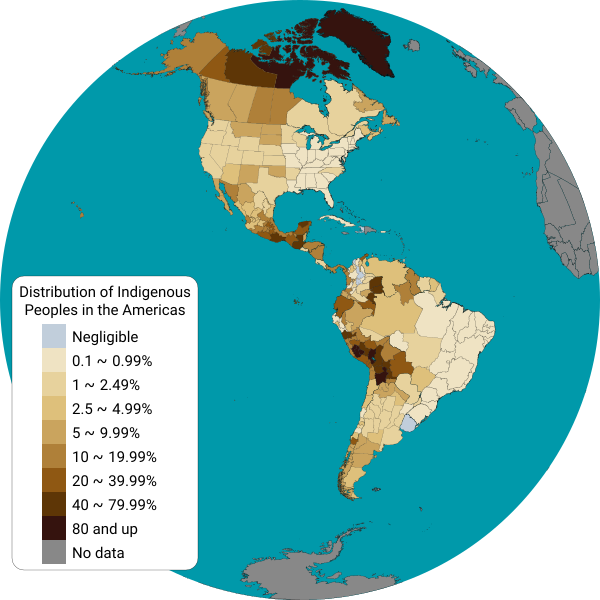
English: This map displays the distribution of indigenous people from each country in the Americas. Detailed information is displayed for Canadian provinces, U.S. states, Mexican states, Brazilian states and Chilean regions.
Map shapes from Natural Earth data, projected into a Lambert Azimuthal Equal-Area projection using a Python script. Data sources:
Español: Este mapa muestra el porcentaje de población indígena por cada país de América. Se muestra información detallada para las provincias de Canadá, los estados de los Estados Unidos, los estados de México, los estados de Brasil, los departamentos del Perú y de Bolivia, las provincias de la Argentina, y las regiones de Chile. |
| Päiväys | |
| Lähde | Oma teos |
| Tekijä | Locoluis |
Lisenssi
Minä, tämän teoksen tekijänoikeuksien haltija, julkaisen täten tämän teoksen seuraavalla lisenssillä:
Tämä tiedosto on lisensoitu Creative Commons Nimeä-JaaSamoin 4.0 Kansainvälinen -lisenssillä.
- Voit:
- jakaa – kopioida, levittää ja esittää teosta
- remiksata – valmistaa muutettuja teoksia
- Seuraavilla ehdoilla:
- nimeäminen – Sinun on mainittava lähde asianmukaisesti, tarjottava linkki lisenssiin sekä merkittävä, mikäli olet tehnyt muutoksia. Voit tehdä yllä olevan millä tahansa kohtuullisella tavalla, mutta et siten, että annat ymmärtää lisenssinantajan suosittelevan sinua tai teoksen käyttöäsi.
- jaa samoin – Jos muutat tai perustat tähän työhön, voit jakaa tuloksena syntyvää työtä vain tällä tai tämän kaltaisella lisenssillä.
Tiedoston historia
Päiväystä napsauttamalla näet, millainen tiedosto oli kyseisellä hetkellä.
| Päiväys | Pienoiskuva | Koko | Käyttäjä | Kommentti | |
|---|---|---|---|---|---|
| nykyinen | 7. kesäkuuta 2022 kello 05.03 | | 3 200 × 3 200 (2,13 MiB) | DemonDays64 | Converted text to Roboto path for consistent display. Also deleted the NOR path and removed some of the tiny dots of islands from NW Hawaii -- more border than anything and the NOR object was right on the edge making it look weird |
| 16. syyskuuta 2021 kello 19.34 |  | 3 200 × 3 200 (2,07 MiB) | Abbasi786786 | 2020 US Census Update | |
| 8. heinäkuuta 2017 kello 21.53 |  | 3 200 × 3 200 (6,58 MiB) | Locoluis | Colombia https://www.dane.gov.co/files/censo2005/etnia/sys/visibilidad_estadistica_etnicos.pdf | |
| 2. toukokuuta 2016 kello 09.06 |  | 1 600 × 1 600 (6,4 MiB) | Locoluis | Argentina | |
| 14. maaliskuuta 2016 kello 05.45 |  | 1 600 × 1 600 (6,4 MiB) | Locoluis | Added data for Peru and Bolivia | |
| 29. maaliskuuta 2015 kello 08.38 |  | 1 600 × 1 600 (6,4 MiB) | Locoluis | Broke Antarctica in the process... | |
| 29. maaliskuuta 2015 kello 07.56 |  | 1 600 × 1 600 (6,52 MiB) | Locoluis | * Fixed Canada * Added lakes * Added Brazil data from http://www.ibge.gov.br/indigenas/indigena_censo2010.pdf * Added another color category. | |
| 29. maaliskuuta 2015 kello 04.50 |  | 1 600 × 1 600 (3,37 MiB) | Locoluis | French Guiana, simplified redundant points, color scheme. | |
| 29. maaliskuuta 2015 kello 04.07 |  | 1 600 × 1 600 (8,43 MiB) | Locoluis | There was a CSS rule that displayed all US, CA, MX and CA regional polygons after all others were hidden. It didn't work. | |
| 29. maaliskuuta 2015 kello 04.02 |  | 1 600 × 1 600 (8,43 MiB) | Locoluis | Oops... |
Tiedoston käyttö
Seuraava sivu käyttää tätä tiedostoa:
Tiedoston järjestelmänlaajuinen käyttö
Seuraavat muut wikit käyttävät tätä tiedostoa:
- Käyttö kohteessa ar.wikipedia.org
- Käyttö kohteessa ast.wikipedia.org
- Käyttö kohteessa be.wikipedia.org
- Käyttö kohteessa bg.wikipedia.org
- Käyttö kohteessa ca.wikipedia.org
- Käyttö kohteessa cs.wikipedia.org
- Käyttö kohteessa de.wikipedia.org
- Käyttö kohteessa en.wikipedia.org
- Käyttö kohteessa eo.wikipedia.org
- Käyttö kohteessa et.wikipedia.org
- Käyttö kohteessa fr.wikipedia.org
- Käyttö kohteessa fy.wikipedia.org
- Käyttö kohteessa ga.wikipedia.org
- Käyttö kohteessa he.wikipedia.org
- Käyttö kohteessa ia.wikipedia.org
- Käyttö kohteessa id.wikipedia.org
- Käyttö kohteessa ja.wikipedia.org
- Käyttö kohteessa ko.wikipedia.org
- Käyttö kohteessa ky.wikipedia.org
- Käyttö kohteessa mk.wikipedia.org
- Käyttö kohteessa oc.wikipedia.org
- Käyttö kohteessa pt.wikipedia.org
- Käyttö kohteessa ro.wikipedia.org
- Käyttö kohteessa rue.wikipedia.org
- Käyttö kohteessa sr.wikipedia.org
- Käyttö kohteessa szy.wikipedia.org
- Käyttö kohteessa tr.wikipedia.org
- Käyttö kohteessa vec.wikipedia.org
- Käyttö kohteessa vi.wikipedia.org
- Käyttö kohteessa www.wikidata.org
- Käyttö kohteessa zh.wikipedia.org