Alkuperäinen tiedosto (705 × 705 kuvapistettä, 135 KiB, MIME-tyyppi: image/png)

Yhteenveto

Kuvaus
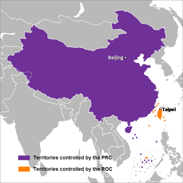
English: This is a map of the two states that officially use the name "China" in their names and depicts the actual "line of control" and not any claims that states often make. Key words: actual administration and actual maintaining of control of the territories.
中文(简体):这是一个关于两个都把“中华”用在自己的国名里的国家的地图,这个地图描绘了两国的实际“控制线”并跟两国通常声称的完全不是一回事。关键词:实际管辖和维持实际控制区域。
中文(繁體):中華民國與中華人民共和國的實控區域圖
Päiväys 24. syyskuuta 2007 (alkuperäinen tallennuspäivä)
Lähde Siirretty projektista en.wikipedia Commonsiin käyttäjän Sreejithk2000 toimesta työkalulla CommonsHelper.
Tekijä Nat projektissa Wikipedia kielellä englanti

Lisenssi

Nat projektissa Wikipedia kielellä englanti, tämän teoksen tekijänoikeuksien haltija, julkaisee täten tämän teoksen seuraavilla lisensseillä:
GNU head Voit kopioida, levittää ja/tai muuttaa tätä asiakirjaa GNU Free Documentation License -lisenssin version 1.2 tai minkä tahansa Free Software Foundationin julkaiseman myöhemmän version ehtojen alaisena; ei koske muuttumattomia kohtia, etukannen tekstejä eikä takakannen tekstejä. Kopio tästä lisenssistä on saatavilla osiossa GNU Free Documentation License.
w:fi:Creative Commons
nimeäminen
Tämä tiedosto on lisensoitu Creative Commons Nimeä 3.0 Ei sovitettu -lisenssillä.
Nimeä: Nat projektissa Wikipedia kielellä englanti
Voit:
  • jakaa – kopioida, levittää ja esittää teosta
  • remiksata – valmistaa muutettuja teoksia
Seuraavilla ehdoilla:
  • nimeäminen – Sinun on mainittava lähde asianmukaisesti, tarjottava linkki lisenssiin sekä merkittävä, mikäli olet tehnyt muutoksia. Voit tehdä yllä olevan millä tahansa kohtuullisella tavalla, mutta et siten, että annat ymmärtää lisenssinantajan suosittelevan sinua tai teoksen käyttöäsi.
Voit valita haluamasi lisenssin.

Alkuperäinen tallennusloki

Alkuperäinen kuvaussivu oli täällä. Käyttäjätunnukset alla viittaavat kohteeseen en.wikipedia.
  • 2008-05-29 22:44 Shibo77 705×705× (136871 bytes)
  • 2008-05-29 21:59 Shibo77 705×705× (135686 bytes)
  • 2008-05-29 21:53 Shibo77 705×705× (132630 bytes) Reverted to version as of 00:46, 16 May 2008
  • 2008-05-29 08:51 Sontung007 556×537× (31782 bytes) Reverted to the neutral version to avoid disputes and ambiguity
  • 2008-05-16 00:46 Taktser 705×705× (132630 bytes)
  • 2008-05-16 00:44 Taktser 705×705× (132710 bytes)
  • 2008-05-03 20:22 T-1000 705×705× (115888 bytes) Reverted to version as of 22:31, 4 April 2008
  • 2008-04-08 17:10 Heavyrain2408 705×705× (129360 bytes) Chinese people use tricky word "administration" to mislead readers to believe these islands belonging to them. Please stop these kinds of actions.
  • 2008-04-04 22:31 Taktser 705×705× (115888 bytes) Reverted to version as of 20:02, 27 March 2008 (administration is clearly stated, not the question of sovereignty over these territories, Arunachal Pradesh is excluded; Aksai Chin, the Spratly islands and some of the Paracel islands are included)
  • 2008-03-30 05:36 Heavyrain2408 705×705× (129360 bytes) Constroversary parts should not be included. This could result readers think that these parts belong to China.
  • 2008-03-27 20:02 Taktser 705×705× (115888 bytes) Reverted to version as of 20:31, 10 March 2008 It's clearly stated as administration not sovereignty
  • 2008-03-21 21:11 Sontung007 705×705× (129360 bytes) the previous map wrongly included unresolved disputed islands
  • 2008-03-10 20:31 Taktser 705×705× (115888 bytes) Reverted to version as of 16:33, 16 November 2007
  • 2008-01-24 15:26 Sinoevils 705×705× (129360 bytes) This is the real China Map
  • 2008-01-24 15:24 Sinoevils 705×705× (129360 bytes) This is the real China Map
  • 2007-11-16 16:33 Nat 705×705× (115888 bytes)
  • 2007-11-06 18:53 Nat 556×537× (30702 bytes)
  • 2007-11-05 22:48 Nat 556×537× (33377 bytes)
  • 2007-10-28 07:25 Jjhcap99 556×537× (31782 bytes) Added country names.
  • 2007-10-19 22:35 Jerrch 556×537× (30043 bytes) Capitalized the capitals
  • 2007-10-16 22:23 Nat 556×537× (30403 bytes) Reverted to version as of 19:37, 9 October 2007
  • 2007-10-16 20:34 Jerrch 556×537× (30411 bytes) Reverted to version as of 19:56, 29 September 2007
  • 2007-10-15 13:05 Jjhcap99 556×537× (33989 bytes)
  • 2007-10-09 19:37 Nat 556×537× (30403 bytes) This is the work of {{user|Nat}}
  • 2007-10-09 19:32 Nat 556×537× (32238 bytes) This is the work of {{User7|Nat}}.
  • 2007-09-29 19:56 Jerrch 556×537× (30411 bytes) changed color a little bit to make it just a little more neutral.
  • 2007-09-24 23:16 Nat 556×537× (30343 bytes)
  • 2007-09-24 01:44 Nat 1127×1069× (958918 bytes)
Annotations
InfoField
This image is annotated: View the annotations at Commons

Kuvatekstit

Lisää yhden rivin pituinen kuvaus tästä tiedostosta
Map of the areas actually controlled by the Republic of China (Taiwan) and the People's Republic of China (China)

Kohteet, joita tässä tiedostossa esitetään

esittää

24. syyskuu 2007

image/png

a3914e0e367e3234152db8229f8c9413a6fc7c3e

138 578 tavu

705 pikseli

705 pikseli

Tiedoston historia

Päiväystä napsauttamalla näet, millainen tiedosto oli kyseisellä hetkellä.

PäiväysPienoiskuvaKokoKäyttäjäKommentti
nykyinen15. joulukuuta 2014 kello 08.14Pienoiskuva 15. joulukuuta 2014 kello 08.14 tallennetusta versiosta705 × 705 (135 KiB)Shibo77..
2. kesäkuuta 2010 kello 12.26Pienoiskuva 2. kesäkuuta 2010 kello 12.26 tallennetusta versiosta705 × 705 (134 KiB)File Upload Bot (Magnus Manske) {{BotMoveToCommons|en.wikipedia|year={{subst:CURRENTYEAR}}|month={{subst:CURRENTMONTHNAME}}|day={{subst:CURRENTDAY}}}} {{Information |Description={{en|This is a map of the two states that officially use the name "China" in their names and depicts the act

Seuraava sivu käyttää tätä tiedostoa:

Tiedoston järjestelmänlaajuinen käyttö

Seuraavat muut wikit käyttävät tätä tiedostoa:

Näytä lisää tämän tiedoston järjestelmänlaajuista käyttöä.

Metatieto