Tiedosto:Cape of Good Hope Iss059e078303 lrg.jpg
Tämän esikatselun koko: 800 × 533 kuvapistettä. Muut resoluutiot: 320 × 213 kuvapistettä | 640 × 427 kuvapistettä | 1 024 × 683 kuvapistettä | 1 280 × 853 kuvapistettä | 2 560 × 1 707 kuvapistettä | 5 568 × 3 712 kuvapistettä.
Alkuperäinen tiedosto (5 568 × 3 712 kuvapistettä, 4,14 MiB, MIME-tyyppi: image/jpeg)
| Tämä tiedosto on tiedostotietokanta Wikimedia Commonsista. Tiedot kuvaussivulta näkyvät alla. |  |
Tiedoston kuvaussivu Commonsissa |
Yhteenveto
| Kuvaus |
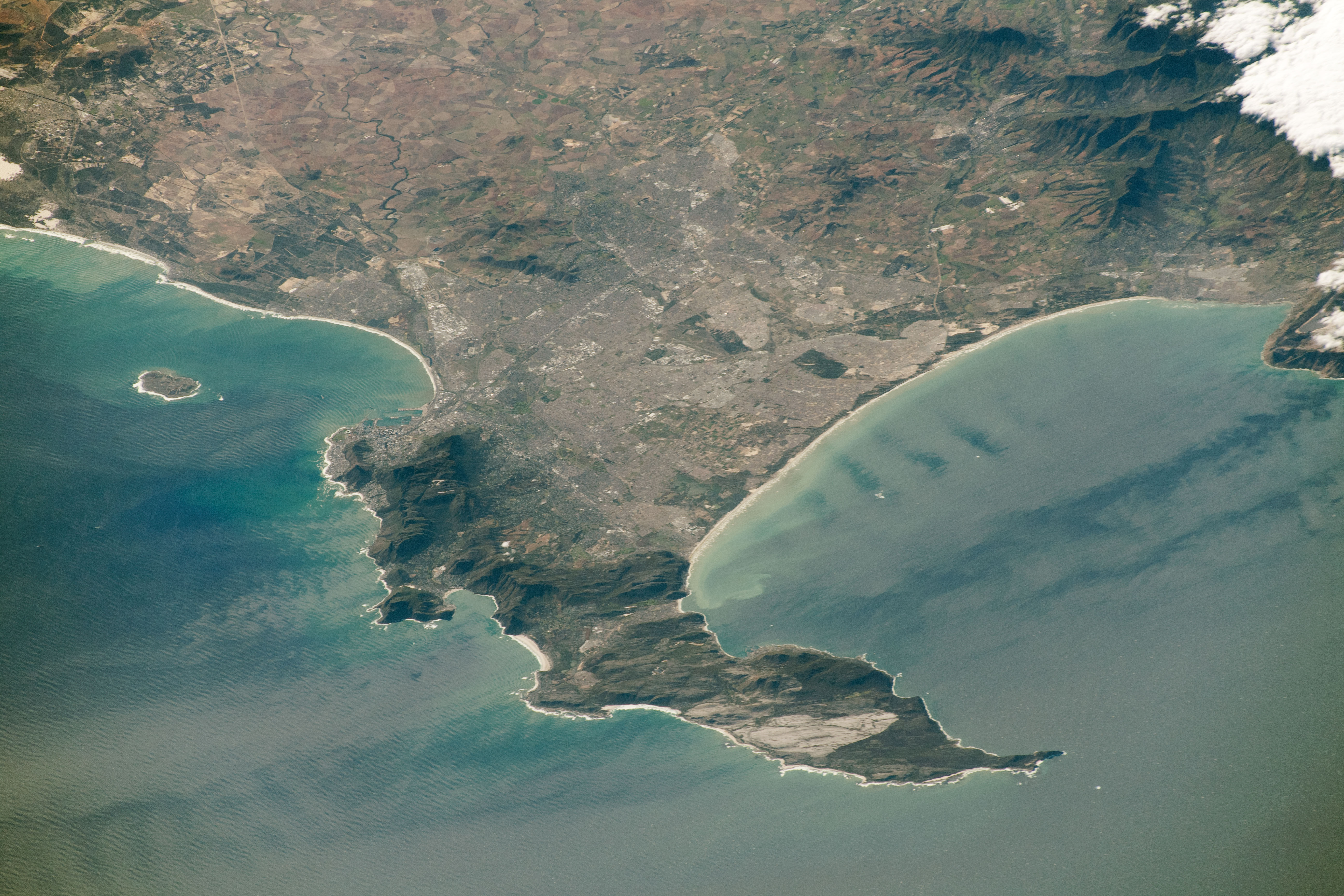
Afrikaans: Uitsig oor Kaapstad, die Kaapse Skiereiland en Kaapse Vlakte vanuit die Internasionale Ruimtestasie. Ruimtevaarderfoto ISS059-E-78303 is op 28 Mei 2019 verkry deur middel van 'n Nikon D5 digitale kamera met 340 millimeter lens, en is voorsien deur die IRS-bemanning se Aardwaarnemingsgerief en die Aardwetenskap-en-Afstandwaarnemingseenheid van die Johnson-ruimtesentrum. Die foto is geneem deur 'n lid van die Ekspedisie 59-span. Die beeld is geknip, die kontras is verbeter en lens-artefakte is verwyder.
English: View of City of Cape Town showing the Cape Peninsula and Cape Flats from the International Space Station. Astronaut photograph ISS059-E-78303 was acquired on May 28, 2019, with a Nikon D5 digital camera using a 340 millimeter lens and is provided by the ISS Crew Earth Observations Facility and the Earth Science and Remote Sensing Unit, Johnson Space Center. The image was taken by a member of the Expedition 59 crew. The image has been cropped and enhanced to improve contrast, and lens artifacts have been removed. |
| Päiväys | |
| Lähde | https://eoimages.gsfc.nasa.gov/images/imagerecords/145000/145476/iss059e078303_lrg.jpg |
| Tekijä |
Afrikaans: Die Internasionale Ruimtestasieprogram ondersteun die laboratorium as deel van die IRS Nasionale Laboratorium om ruimtevaarders te help om foto's van die Aarde te neem wat die grootste waarde vir wetenskaplikes en die publiek sal hê, en om hierdie beelde vrylik op die internet beskikbaar te stel. Bykomende beelde wat deur ruimtevaarders en kosmonoute geneem is, kan besigtig word by die NASA/JSC Gateway to Astronaut Photography of Earth. Onderskrif deur Sarah Deitrick, 'n Jacobs-JETS-gekontrakteerde by NASA-JSC.
English: The International Space Station Program supports the laboratory as part of the ISS National Lab to help astronauts take pictures of Earth that will be of the greatest value to scientists and the public, and to make those images freely available on the Internet. Additional images taken by astronauts and cosmonauts can be viewed at the NASA/JSC Gateway to Astronaut Photography of Earth. Caption by Sarah Deitrick, Jacobs-JETS Contract at NASA-JSC. |
| Muut versiot |
  |
| Kohteen sijainti | | Tämä ja muut kuvat kartalla: OpenStreetMap |
|---|
Lisenssi
| Tämä teos on ilman tekijänoikeuden suojaa, koska National Aeronautics and Space Administration (NASA) loi sen. Koska Nasa on Yhdysvaltain liittovaltion organisaatio, sen luomat teokset ovat ilman tekijänoikeuden suojaa. ([1][2]) | ||
 |
Varoitukset:
|
Tiedoston historia
Päiväystä napsauttamalla näet, millainen tiedosto oli kyseisellä hetkellä.
| Päiväys | Pienoiskuva | Koko | Käyttäjä | Kommentti | |
|---|---|---|---|---|---|
| nykyinen | 28. elokuuta 2019 kello 12.21 | | 5 568 × 3 712 (4,14 MiB) | Pbsouthwood | User created page with UploadWizard |
Tiedoston käyttö
Seuraava sivu käyttää tätä tiedostoa:
Tiedoston järjestelmänlaajuinen käyttö
Seuraavat muut wikit käyttävät tätä tiedostoa:
- Käyttö kohteessa en.wikipedia.org
- Käyttö kohteessa en.wiktionary.org
- Käyttö kohteessa pt.wikipedia.org
- Käyttö kohteessa ur.wikipedia.org