Tiedosto:Bundesautobahn 4 map.png

Tämän esikatselun koko: 444 × 600 kuvapistettä. Muut resoluutiot: 178 × 240 kuvapistettä | 355 × 480 kuvapistettä | 569 × 768 kuvapistettä | 1 122 × 1 515 kuvapistettä.
Alkuperäinen tiedosto (1 122 × 1 515 kuvapistettä, 80 KiB, MIME-tyyppi: image/png)
| Tämä tiedosto on tiedostotietokanta Wikimedia Commonsista. Tiedot kuvaussivulta näkyvät alla. |  |
Tiedoston kuvaussivu Commonsissa |
Yhteenveto
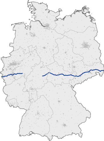
Deutsch: Verlauf der Bundesautobahn 4 in Deutschland
English: Bundesautobahn 4 in Germany
Lisenssi
This image was generated with OpenGeoDB. The information there is placed in the public domain, images generated from OpenGeoDB are derivative works without passing the threshold of creativity, they are therefore also public domain.
| Tämä tiedosto ei ylitä teoskynnystä, joten se ei saa tekijänoikeuden suojaa. |
Tiedoston historia
Päiväystä napsauttamalla näet, millainen tiedosto oli kyseisellä hetkellä.
| Päiväys | Pienoiskuva | Koko | Käyttäjä | Kommentti | |
|---|---|---|---|---|---|
| nykyinen | 13. syyskuuta 2005 kello 12.07 | | 1 122 × 1 515 (80 KiB) | Qualle | Bundesautobahn 4 in Germany 004 |
Tiedoston käyttö
Seuraava sivu käyttää tätä tiedostoa:
Tiedoston järjestelmänlaajuinen käyttö
Seuraavat muut wikit käyttävät tätä tiedostoa:
- Käyttö kohteessa da.wikipedia.org
- Käyttö kohteessa fr.wikipedia.org
- Käyttö kohteessa hr.wikipedia.org
- Käyttö kohteessa hu.wikipedia.org
- Käyttö kohteessa incubator.wikimedia.org
- Käyttö kohteessa ja.wikipedia.org
- Käyttö kohteessa no.wikipedia.org
- Käyttö kohteessa pt.wikipedia.org
- Käyttö kohteessa ru.wikipedia.org
- Käyttö kohteessa sco.wikipedia.org
- Käyttö kohteessa sk.wikipedia.org
- Käyttö kohteessa sr.wikipedia.org
- Käyttö kohteessa tr.wikipedia.org
- Käyttö kohteessa zh.wikipedia.org