Tiedosto:Band-e-Amir National Park, Afghanistan.jpg

Tämän esikatselun koko: 600 × 600 kuvapistettä. Muut resoluutiot: 240 × 240 kuvapistettä | 480 × 480 kuvapistettä | 768 × 768 kuvapistettä | 1 024 × 1 024 kuvapistettä | 2 048 × 2 048 kuvapistettä | 3 500 × 3 500 kuvapistettä.
Alkuperäinen tiedosto (3 500 × 3 500 kuvapistettä, 4,14 MiB, MIME-tyyppi: image/jpeg)
| Tämä tiedosto on tiedostotietokanta Wikimedia Commonsista. Tiedot kuvaussivulta näkyvät alla. |  |
Tiedoston kuvaussivu Commonsissa |
Yhteenveto
| Kuvaus |
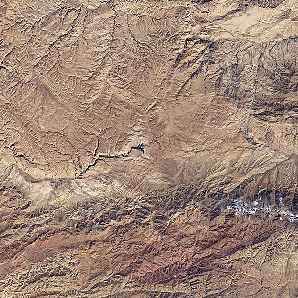
English: The starkness of the landscape highlights the ruggedness of the terrain around the lakes in this satellite image of Band-e-Amir National Park. Towering cliffs create sharp lines and shadows on the south (bottom) side of many of the lakes. The lakes range in color from faint turquoise to deep blue. |
| Päiväys | |
| Lähde | NASA Earth Observatory |
| Tekijä | NASA image created by Jesse Allen, using Landsat data provided by the United States Geological Survey. |
Landsat 7 - ETM+
Lisenssi
| Tämä teos on ilman tekijänoikeuden suojaa, koska National Aeronautics and Space Administration (NASA) loi sen. Koska Nasa on Yhdysvaltain liittovaltion organisaatio, sen luomat teokset ovat ilman tekijänoikeuden suojaa. ([1][2]) | ||
 |
Varoitukset:
|
Tiedoston historia
Päiväystä napsauttamalla näet, millainen tiedosto oli kyseisellä hetkellä.
| Päiväys | Pienoiskuva | Koko | Käyttäjä | Kommentti | |
|---|---|---|---|---|---|
| nykyinen | 26. huhtikuuta 2009 kello 17.42 | | 3 500 × 3 500 (4,14 MiB) | Originalwana | {{Information |Description={{en|1=The starkness of the landscape highlights the ruggedness of the terrain around the lakes in this satellite image of Band-e-Amir National Park. Towering cliffs create sharp lines and shadows on the south side of many of th |
Tiedoston käyttö
Seuraava sivu käyttää tätä tiedostoa:
Tiedoston järjestelmänlaajuinen käyttö
Seuraavat muut wikit käyttävät tätä tiedostoa:
- Käyttö kohteessa az.wikipedia.org
- Käyttö kohteessa bg.wikipedia.org
- Käyttö kohteessa en.wikipedia.org
- Käyttö kohteessa id.wikipedia.org
- Käyttö kohteessa no.wikipedia.org
- Käyttö kohteessa pa.wikipedia.org
- Käyttö kohteessa ru.wikipedia.org
- Käyttö kohteessa sat.wikipedia.org
- Käyttö kohteessa sv.wikipedia.org
- Käyttö kohteessa uk.wikipedia.org