Tiedosto:Abemama Map.jpg

Alkuperäinen tiedosto (5 310 × 5 667 kuvapistettä, 1,32 MiB, MIME-tyyppi: image/jpeg)
| Tämä tiedosto on tiedostotietokanta Wikimedia Commonsista. Tiedot kuvaussivulta näkyvät alla. |  |
Tiedoston kuvaussivu Commonsissa |
Yhteenveto
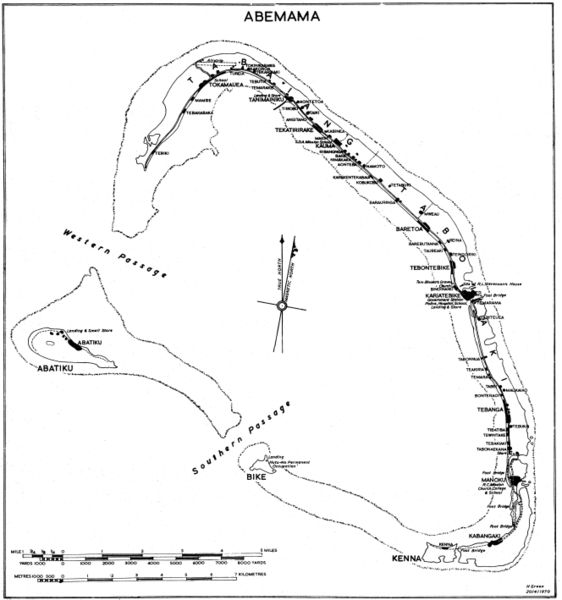
Government map (some maps in the series include the following: "Compiled by Lands and Surveys, Betio, Tarawa") with inscription "H Green 20/4/1970". Original obtained either directly from GEIDA of from a U.S. Government source (USACOE) as a blueline printing sometime in the 1970s. I believe these maps were produced for government use by the Gilbert Islands Colony. I have scanned and slightly altered the original (1/50,000 scale). Maps such as this one showing village locations on Pacific islands are difficult to come by. - Marshman 18:16, 28 November 2005 (UTC)
Lisenssi
Tämä teos ei saa tekijänoikeuden suojaa, koska tämä on Yhdysvaltain liittovaltion viranomaisen tekemä teos. Yhdysvaltain tekijänoikeuslain 105 § mukaisesti tällaisiin teoksiin ei ole tekijänoikeutta.
Tämä koskee vain liittovaltion viranomaisen tekemiä teoksia. Tämä ei koske osavaltion, territorion, piirikunnan, kunnan tai minkään muun pienemmän hallinnollisen alueen viranomaisten tekemiä teoksia. Yhdysvaltain postipalvelu pidättää oikeudet vuoden 1977 jälkeen julkaistuihin postimerkkeihin ([1]), joten tätä mallinetta ei voi käyttää myöskään niille. |
 | |
| Tämä teos on vapaa tunnetuista tekijänoikeuslain mukaisista rajoituksista, mukaanlukien lähioikeuksista. | ||
Tiedoston historia
Päiväystä napsauttamalla näet, millainen tiedosto oli kyseisellä hetkellä.
| Päiväys | Pienoiskuva | Koko | Käyttäjä | Kommentti | |
|---|---|---|---|---|---|
| nykyinen | 28. marraskuuta 2005 kello 23.07 | | 5 310 × 5 667 (1,32 MiB) | Marshman~commonswiki | Slightly larger version of same |
| 28. marraskuuta 2005 kello 21.13 |  | 3 540 × 3 778 (708 KiB) | Marshman~commonswiki | Government map with inscription "H Green 20/4/1970" I obtained the "original" as a blueline printing in the 1970s. I believe these maps were produced for government use by the Gilbert Islands Colony. I have scanned and slightly altered the original (1/50 |
Tiedoston käyttö
Seuraava sivu käyttää tätä tiedostoa:
Tiedoston järjestelmänlaajuinen käyttö
Seuraavat muut wikit käyttävät tätä tiedostoa:
- Käyttö kohteessa ce.wikipedia.org
- Käyttö kohteessa de.wikipedia.org
- Käyttö kohteessa el.wikipedia.org
- Käyttö kohteessa en.wikipedia.org
- Käyttö kohteessa es.wikipedia.org
- Käyttö kohteessa gl.wikipedia.org
- Käyttö kohteessa he.wikipedia.org
- Käyttö kohteessa hu.wikipedia.org
- Käyttö kohteessa ka.wikipedia.org
- Käyttö kohteessa mk.wikipedia.org
- Käyttö kohteessa pt.wikipedia.org
- Käyttö kohteessa ru.wikipedia.org