Tiedosto:1920 Helsinki tram map.png

Tämän esikatselun koko: 628 × 600 kuvapistettä. Muut resoluutiot: 251 × 240 kuvapistettä | 502 × 480 kuvapistettä | 804 × 768 kuvapistettä | 1 256 × 1 200 kuvapistettä.
Alkuperäinen tiedosto (1 256 × 1 200 kuvapistettä, 85 KiB, MIME-tyyppi: image/png)
| Tämä tiedosto on tiedostotietokanta Wikimedia Commonsista. Tiedot kuvaussivulta näkyvät alla. |  |
Tiedoston kuvaussivu Commonsissa |
Yhteenveto
| Kuvaus |
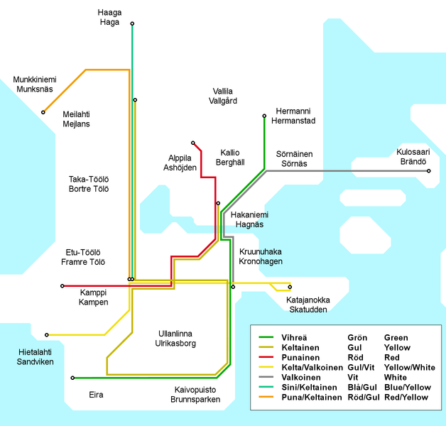
English: Map of the Helsinki tram network as it appeared in 1920-1922. At this time lines were identified solely by their colour combinations and had no numbers or letters as identifiers. The colours used on this map do not wholly match the original colours, in order to maintain the colours as identifiers of the same lines for all the historical Helsinki tram maps.
Suomi: Helsingin raitoteiden linjakartta sellaisena, kuin se oli vuosina 1920-1922. Ennen vuotta 1926 linjoilla ei ollut numero- tai kirjaintunnuksia, vaan ainoastaan värilliset tunnuskilvet. Tämän kartan linjavärit eivät täysin vastaa alkuperäisiä, vaan värit ovat samat kuin muissa Helsingin raitiotieverkon vaiheita käsittelevissä kartoissa.
Svenska: Kartan över Helsingfors spårvägsnätet 1920-1922. Före 1926 spårvägslinjer i Helsingors hade ingen nummer- eller bokstavidentifiering, bara linjefärger. Linjefärger i denna karta är inte precis de samma som orignalfärgerna. |
| Päiväys | |
| Lähde | Oma teos |
| Tekijä | Kalle Id |

|
Tämä tyyppiä rail transport map oleva kuva pitäisi luoda uudelleen SVG-tiedostoksi vektorigrafiikan avulla. Tällä tiedostotyypillä on monia vahvuuksia, sivulta Commons:Media for cleanup löytyy lisätietoja. Jos tästä kuvasta on jo olemassa SVG-versio, ole ystävällinen ja tallenna se tänne. SVG-tiedoston tallentamisen jälkeen vaihda tämä malline mallineeseen {{vector version available|uusi kuvan nimi.svg}}.
|
Lisenssi
Minä, tämän teoksen tekijänoikeuksien haltija, julkaisen täten tämän teoksen seuraavalla lisenssillä:
Tämä tiedosto on lisensoitu Creative Commons Nimeä-JaaSamoin 3.0 Ei sovitettu -lisenssillä.
- Voit:
- jakaa – kopioida, levittää ja esittää teosta
- remiksata – valmistaa muutettuja teoksia
- Seuraavilla ehdoilla:
- nimeäminen – Sinun on mainittava lähde asianmukaisesti, tarjottava linkki lisenssiin sekä merkittävä, mikäli olet tehnyt muutoksia. Voit tehdä yllä olevan millä tahansa kohtuullisella tavalla, mutta et siten, että annat ymmärtää lisenssinantajan suosittelevan sinua tai teoksen käyttöäsi.
- jaa samoin – Jos muutat tai perustat tähän työhön, voit jakaa tuloksena syntyvää työtä vain tällä tai tämän kaltaisella lisenssillä.
Tiedoston historia
Päiväystä napsauttamalla näet, millainen tiedosto oli kyseisellä hetkellä.
| Päiväys | Pienoiskuva | Koko | Käyttäjä | Kommentti | |
|---|---|---|---|---|---|
| nykyinen | 30. kesäkuuta 2010 kello 15.12 | | 1 256 × 1 200 (85 KiB) | Kjet | Bilingual district names, trilingual line identifiers, altered colours to better match the original, improveed grographical accuracy. |
| 18. lokakuuta 2008 kello 19.39 |  | 1 256 × 1 200 (53 KiB) | Kjet | {{Information |Description={{en|1=Map of the Helsinki tram network as it appeared in 1920-1922. At this time lines were identified solely by their colour combinations and had no numbers or letters as identifiers. The colours used on this map do not wholly |
Tiedoston käyttö
Seuraava sivu käyttää tätä tiedostoa:
Tiedoston järjestelmänlaajuinen käyttö
Seuraavat muut wikit käyttävät tätä tiedostoa:
- Käyttö kohteessa en.wikipedia.org
- Käyttö kohteessa fr.wikipedia.org
- Käyttö kohteessa uk.wikipedia.org