Tiedosto:070727 New Washington ADIZ-FRZ.jpg
Tämän esikatselun koko: 780 × 600 kuvapistettä. Muut resoluutiot: 312 × 240 kuvapistettä | 624 × 480 kuvapistettä | 900 × 692 kuvapistettä.
Alkuperäinen tiedosto (900 × 692 kuvapistettä, 220 KiB, MIME-tyyppi: image/jpeg)
| Tämä tiedosto on tiedostotietokanta Wikimedia Commonsista. Tiedot kuvaussivulta näkyvät alla. |  |
Tiedoston kuvaussivu Commonsissa |
Yhteenveto
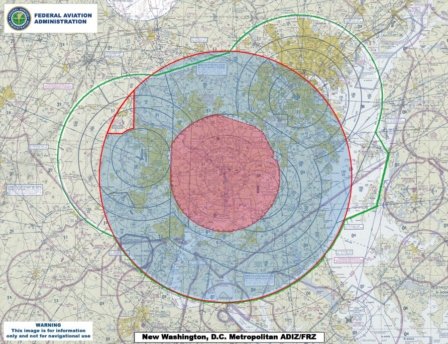
| Kuvaus | This map compares the new Air Defense Identification Zone (ADIZ) surrounding Washington, D.C. (red line) with the old ADIZ (green line). The new zone is effective as of 0500 UTC, 30 Aug 2007. The shaded red circle in the middle is the restricted airspace surrounding the capital. |
| Päiväys | |
| Lähde | U.S. Federal Aviation Administration (http://www.faa.gov) - http://www.faa.gov/news/updates/adiz_frz/media/070727_New_ADIZ-FRZ.jpg |
| Tekijä | U.S. Federal Aviation Administration |
Lisenssi
This image or file is a work of a Federal Aviation Administration employee, taken or made as part of that person's official duties. As a work of the U.S. federal government, the image is in the public domain in the United States.
|
 |
Tiedoston historia
Päiväystä napsauttamalla näet, millainen tiedosto oli kyseisellä hetkellä.
| Päiväys | Pienoiskuva | Koko | Käyttäjä | Kommentti | |
|---|---|---|---|---|---|
| nykyinen | 31. heinäkuuta 2007 kello 03.09 | | 900 × 692 (220 KiB) | Sarfa~commonswiki | This map compares the new Air Defense Identification Zone (ADIZ) surrounding Washington, D.C. (red line) with the old ADIZ (green line). The new zone is effective as of 0500 UTC, 30 Aug 2007. |
Tiedoston käyttö
Seuraava sivu käyttää tätä tiedostoa:
Tiedoston järjestelmänlaajuinen käyttö
Seuraavat muut wikit käyttävät tätä tiedostoa:
- Käyttö kohteessa de.wikipedia.org
- Käyttö kohteessa en.wikipedia.org
- Käyttö kohteessa it.wikipedia.org
- Käyttö kohteessa ja.wikipedia.org
- Käyttö kohteessa ko.wikipedia.org
- Käyttö kohteessa www.wikidata.org
- Käyttö kohteessa zh.wikipedia.org