Tiedosto:ValcourIslandMap1776Detail.jpg

Tämän esikatselun koko: 541 × 599 kuvapistettä. Muut resoluutiot: 217 × 240 kuvapistettä | 434 × 480 kuvapistettä | 803 × 889 kuvapistettä.
Alkuperäinen tiedosto (803 × 889 kuvapistettä, 337 KiB, MIME-tyyppi: image/jpeg)
| Tämä tiedosto on tiedostotietokanta Wikimedia Commonsista. Tiedot kuvaussivulta näkyvät alla. |  |
Tiedoston kuvaussivu Commonsissa |
Yhteenveto
| Kuvaus |
English:

|
||||||||||||||||||||||
| Päiväys | |||||||||||||||||||||||
| Lähde |
From the Boston Public Library Digital Maps Collection (http://maps.bpl.org/). |
||||||||||||||||||||||
| Tekijä |
|
||||||||||||||||||||||
Lisenssi
|
Tämä teos on public domainissa lähes maailmanlaajuisesti, koska tekijän kuolemasta on kulunut yli 100 vuotta. | |
| Tämä teos on vapaa tunnetuista tekijänoikeuslain mukaisista rajoituksista, mukaanlukien lähioikeuksista. | |
Tiedoston historia
Päiväystä napsauttamalla näet, millainen tiedosto oli kyseisellä hetkellä.
| Päiväys | Pienoiskuva | Koko | Käyttäjä | Kommentti | |
|---|---|---|---|---|---|
| nykyinen | 18. helmikuuta 2009 kello 00.29 | | 803 × 889 (337 KiB) | Magicpiano | Higher-res version. |
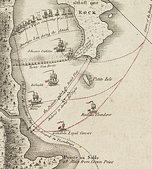
| 18. helmikuuta 2009 kello 00.23 |  | 189 × 214 (23 KiB) | Magicpiano | {{Information |Description={{en|1=thumb|right|source map showing area detailed in this image This is a blowup of the area highlighted in the map shown to the right, showing the detail of the action in the [[w:Bat |
Tiedoston käyttö
Seuraava sivu käyttää tätä tiedostoa:
Tiedoston järjestelmänlaajuinen käyttö
Seuraavat muut wikit käyttävät tätä tiedostoa:
- Käyttö kohteessa ca.wikipedia.org
- Käyttö kohteessa de.wikipedia.org
- Käyttö kohteessa en.wikipedia.org
- Käyttö kohteessa es.wikipedia.org
- Käyttö kohteessa fr.wikipedia.org
- Käyttö kohteessa it.wikipedia.org
- Käyttö kohteessa ja.wikipedia.org
- Käyttö kohteessa no.wikipedia.org
- Käyttö kohteessa ru.wikipedia.org
- Käyttö kohteessa simple.wikipedia.org
- Käyttö kohteessa www.wikidata.org