Tiedosto:Un-liberia.png
Alkuperäinen tiedosto (3 037 × 2 257 kuvapistettä, 1,42 MiB, MIME-tyyppi: image/png)
| Tämä tiedosto on tiedostotietokanta Wikimedia Commonsista. Tiedot kuvaussivulta näkyvät alla. |  |
Tiedoston kuvaussivu Commonsissa |
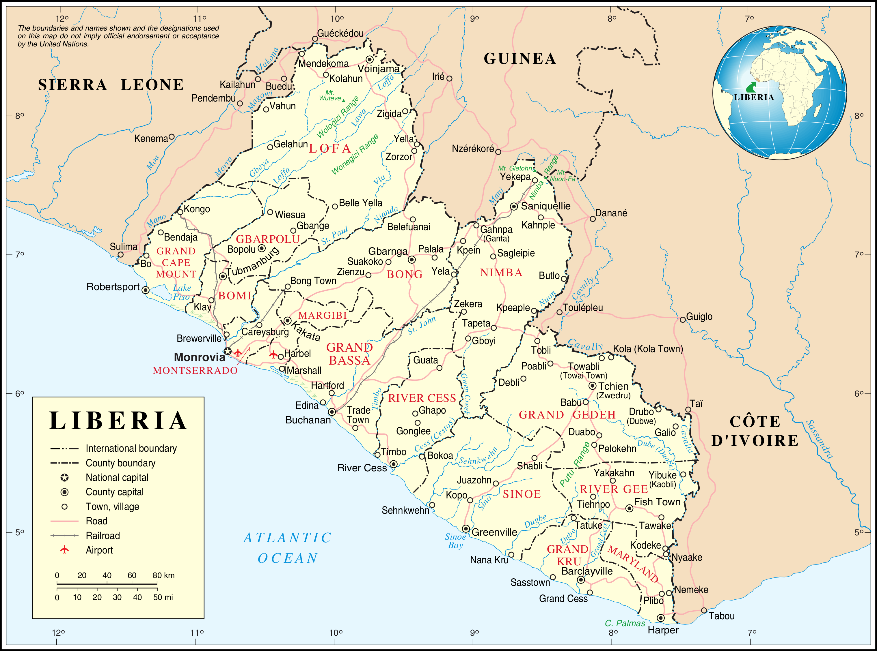
| This image is a map derived from a United Nations map.
Unless stated otherwise, UN maps are to be considered in the public domain. This applies worldwide. UN maps are, in principle, open source material and you can use them in your work or for making your own map. UN requests however that you delete the UN name, logo and reference number upon any modification to the map. Content of your map will be your responsibility. You can state in your publication, if you wish, something like: based on UN map … (map name, map number, revision number and date). See: Geospatial Information Section. And: Geospatial, location data for a better world. |
 |
Tiedoston historia
Päiväystä napsauttamalla näet, millainen tiedosto oli kyseisellä hetkellä.
| Päiväys | Pienoiskuva | Koko | Käyttäjä | Kommentti | |
|---|---|---|---|---|---|
| nykyinen | 24. lokakuuta 2007 kello 04.29 | | 3 037 × 2 257 (1,42 MiB) | Jeroen | {{UN map}} Category:Maps of Liberia |
Tiedoston käyttö
Seuraavat 3 sivua käyttävät tätä tiedostoa:
Tiedoston järjestelmänlaajuinen käyttö
Seuraavat muut wikit käyttävät tätä tiedostoa:
- Käyttö kohteessa ar.wikipedia.org
- Käyttö kohteessa ast.wikipedia.org
- Käyttö kohteessa az.wikipedia.org
- Käyttö kohteessa bs.wikipedia.org
- Käyttö kohteessa ca.wikipedia.org
- Primera Guerra Civil liberiana
- Resolució 856 del Consell de Seguretat de les Nacions Unides
- Resolució 1020 del Consell de Seguretat de les Nacions Unides
- Resolució 1041 del Consell de Seguretat de les Nacions Unides
- Resolució 1071 del Consell de Seguretat de les Nacions Unides
- Resolució 1395 del Consell de Seguretat de les Nacions Unides
- Resolució 1458 del Consell de Seguretat de les Nacions Unides
- Resolució 1549 del Consell de Seguretat de les Nacions Unides
- Resolució 1579 del Consell de Seguretat de les Nacions Unides
- Resolució 1607 del Consell de Seguretat de les Nacions Unides
- Resolució 1626 del Consell de Seguretat de les Nacions Unides
- Resolució 1683 del Consell de Seguretat de les Nacions Unides
- Resolució 1712 del Consell de Seguretat de les Nacions Unides
- Resolució 1731 del Consell de Seguretat de les Nacions Unides
- Resolució 1750 del Consell de Seguretat de les Nacions Unides
- Resolució 1819 del Consell de Seguretat de les Nacions Unides
- Resolució 1854 del Consell de Seguretat de les Nacions Unides
- Resolució 1885 del Consell de Seguretat de les Nacions Unides
- Resolució 2128 del Consell de Seguretat de les Nacions Unides
- Missió de les Nacions Unides a Libèria
- Käyttö kohteessa ckb.wikipedia.org
- Käyttö kohteessa cs.wikipedia.org
- Käyttö kohteessa de.wikipedia.org
- Käyttö kohteessa de.wikivoyage.org
- Käyttö kohteessa en.wikipedia.org
- List of cities in Liberia
- Outline of Liberia
- Administrative divisions of Liberia
- United Nations Security Council Resolution 856
- United Nations Security Council Resolution 1020
- United Nations Security Council Resolution 1041
- United Nations Security Council Resolution 1071
- Category:Populated places in Liberia
- United Nations Security Council Resolution 1395
Näytä lisää tämän tiedoston järjestelmänlaajuista käyttöä.