Tiedosto:Taklimakanm.jpg

Tämän esikatselun koko: 800 × 600 kuvapistettä. Muut resoluutiot: 320 × 240 kuvapistettä | 640 × 480 kuvapistettä | 1 024 × 768 kuvapistettä | 1 280 × 960 kuvapistettä | 2 560 × 1 920 kuvapistettä | 4 800 × 3 600 kuvapistettä.
Alkuperäinen tiedosto (4 800 × 3 600 kuvapistettä, 2,79 MiB, MIME-tyyppi: image/jpeg)
| Tämä tiedosto on tiedostotietokanta Wikimedia Commonsista. Tiedot kuvaussivulta näkyvät alla. |  |
Tiedoston kuvaussivu Commonsissa |
Yhteenveto
| Kuvaus |
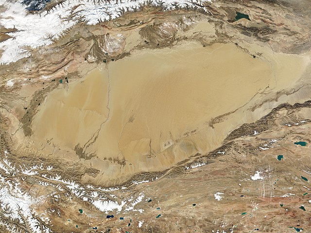
English: The Taklamakan Desert in northwest China is a vast region of sand desert sitting in a depression between two high, rugged mountain ranges. Seen in this true-color MODIS image from October 27, 2001, the Taklimakan's rolling sand dunes stretch out over several hundred thousand square miles in the Xinjiang region of China. The desert is hemmed in to the north by the snow-covered Tien Shan Mountain range and to the south by the rugged Kunlun Mountains. At the lower left corner of the image is the Karakoram Mountain range, where the world's second highest mountain, K2, casts a blue shadow (see high-resolution image for an up-close look). Desertification and shifting sand dunes are a major concern for the farmers and herders who live at the Taklimakan's edge. At the bottom of the image lies the Tibetan Plateau. |
| Päiväys | Kuvattu 27. lokakuuta 2001 |
| Lähde | http://www.gsfc.nasa.gov/indepth/photos_earth2001_p1.html (archive) |
| Tekijä | NASA/GSFC/MODIS Team |
Lisenssi
| Tämä teos on ilman tekijänoikeuden suojaa, koska National Aeronautics and Space Administration (NASA) loi sen. Koska Nasa on Yhdysvaltain liittovaltion organisaatio, sen luomat teokset ovat ilman tekijänoikeuden suojaa. ([1][2]) | ||
 |
Varoitukset:
|
Tiedoston historia
Päiväystä napsauttamalla näet, millainen tiedosto oli kyseisellä hetkellä.
| Päiväys | Pienoiskuva | Koko | Käyttäjä | Kommentti | |
|---|---|---|---|---|---|
| nykyinen | 27. syyskuuta 2020 kello 05.05 | | 4 800 × 3 600 (2,79 MiB) | Huntster | 250m resolution version. |
| 24. elokuuta 2005 kello 00.33 |  | 1 200 × 900 (324 KiB) | Nanosmile | Description: The Taklimakan Desert in northwest China is a vast region of sand desert sitting in a depression between two high, rugged mountain ranges. Seen in this true-color MODIS image from October 27, 2001, the Taklimakan's rolling sand dunes stretch |
Tiedoston käyttö
Seuraavat 2 sivua käyttävät tätä tiedostoa:
Tiedoston järjestelmänlaajuinen käyttö
Seuraavat muut wikit käyttävät tätä tiedostoa:
- Käyttö kohteessa af.wikipedia.org
- Käyttö kohteessa als.wikipedia.org
- Käyttö kohteessa bn.wikipedia.org
- Käyttö kohteessa br.wikipedia.org
- Käyttö kohteessa ca.wikipedia.org
- Käyttö kohteessa de.wikipedia.org
- Käyttö kohteessa en.wikipedia.org
- Käyttö kohteessa eo.wikipedia.org
- Käyttö kohteessa es.wikipedia.org
- Käyttö kohteessa et.wikipedia.org
- Käyttö kohteessa eu.wikipedia.org
- Käyttö kohteessa fa.wikipedia.org
- Käyttö kohteessa fr.wikipedia.org
- Käyttö kohteessa gl.wikipedia.org
- Käyttö kohteessa he.wikipedia.org
- Käyttö kohteessa hu.wikipedia.org
- Käyttö kohteessa hy.wikipedia.org
- Käyttö kohteessa id.wikipedia.org
- Käyttö kohteessa it.wikipedia.org
- Käyttö kohteessa ku.wikipedia.org
- Käyttö kohteessa ky.wikipedia.org
- Käyttö kohteessa nds.wikipedia.org
- Käyttö kohteessa nn.wikipedia.org
- Käyttö kohteessa no.wikipedia.org
- Käyttö kohteessa pt.wikipedia.org
- Käyttö kohteessa ro.wikipedia.org
- Käyttö kohteessa ru.wikipedia.org
- Käyttö kohteessa sr.wikipedia.org
- Käyttö kohteessa th.wikipedia.org
- Käyttö kohteessa tr.wikipedia.org
- Käyttö kohteessa tt.wikipedia.org
Näytä lisää tämän tiedoston järjestelmänlaajuista käyttöä.