Tiedosto:Southern Savage Islands, Atlantic Ocean.jpg
Tämän esikatselun koko: 800 × 533 kuvapistettä. Muut resoluutiot: 320 × 213 kuvapistettä | 640 × 427 kuvapistettä | 1 024 × 683 kuvapistettä | 1 440 × 960 kuvapistettä.
Alkuperäinen tiedosto (1 440 × 960 kuvapistettä, 331 KiB, MIME-tyyppi: image/jpeg)
| Tämä tiedosto on tiedostotietokanta Wikimedia Commonsista. Tiedot kuvaussivulta näkyvät alla. |  |
Tiedoston kuvaussivu Commonsissa |
Yhteenveto
| Kuvaus |
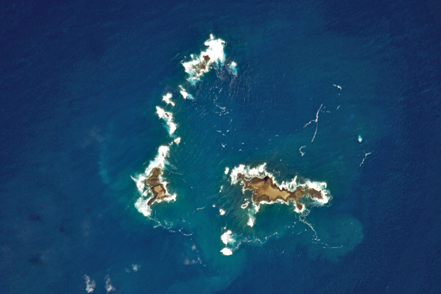
English: The irregularly-shaped Ilhéus do Norte, Ilhéu de Fora, and Selvagem Pequena are visible in the centre of the image. The islands are ringed by bright white breaking waves along the fringing beaches. |
| Päiväys | |
| Lähde | NASA Earth Observatory |
| Tekijä | Image captured by the NASA Expedition 21 crew. |
| Kameran sijainti | | Tämä ja muut kuvat kartalla: OpenStreetMap |
|---|
This image or video was catalogued by Johnson Space Center of the United States National Aeronautics and Space Administration (NASA) under Photo ID: ISS021-E-11833. This tag does not indicate the copyright status of the attached work. A normal copyright tag is still required. See Commons:Licensing. Other languages:
|
Image acquired with a Nikon D2Xs digital camera fitted with an 800 mm lens, and are provided by the ISS Crew Earth Observations experiment and Image Science & Analysis Laboratory, Johnson Space Centre.
Lisenssi
| Tämä teos on ilman tekijänoikeuden suojaa, koska National Aeronautics and Space Administration (NASA) loi sen. Koska Nasa on Yhdysvaltain liittovaltion organisaatio, sen luomat teokset ovat ilman tekijänoikeuden suojaa. ([1][2]) | ||
 |
Varoitukset:
|
| Annotations | This image is annotated: View the annotations at Commons |
Tiedoston historia
Päiväystä napsauttamalla näet, millainen tiedosto oli kyseisellä hetkellä.
| Päiväys | Pienoiskuva | Koko | Käyttäjä | Kommentti | |
|---|---|---|---|---|---|
| nykyinen | 13. huhtikuuta 2011 kello 23.17 | | 1 440 × 960 (331 KiB) | Alexrk2 | digitally enhanced |
| 18. lokakuuta 2010 kello 21.41 |  | 3 072 × 2 037 (618 KiB) | Originalwana | higher res | |
| 23. marraskuuta 2009 kello 15.45 |  | 1 440 × 960 (385 KiB) | Originalwana | {{Information |Description={{en|1=The irregularly-shaped Ilhéus do Norte, Ilhéu de Fora, and Selvagem Pequena are visible in the centre of the image. The islands are ringed by bright white breaking waves along the fringing beaches.}} |Source=[http://ear |
Tiedoston käyttö
Seuraava sivu käyttää tätä tiedostoa:
Tiedoston järjestelmänlaajuinen käyttö
Seuraavat muut wikit käyttävät tätä tiedostoa:
- Käyttö kohteessa an.wikipedia.org
- Käyttö kohteessa ast.wikipedia.org
- Käyttö kohteessa ceb.wikipedia.org
- Käyttö kohteessa en.wikipedia.org
- Käyttö kohteessa en.wikiversity.org
- Käyttö kohteessa es.wikipedia.org
- Käyttö kohteessa eu.wikipedia.org
- Käyttö kohteessa fr.wikipedia.org
- Käyttö kohteessa it.wikipedia.org
- Käyttö kohteessa oc.wikipedia.org
- Käyttö kohteessa pt.wikipedia.org
- Käyttö kohteessa simple.wikipedia.org
- Käyttö kohteessa uk.wikipedia.org
- Käyttö kohteessa www.wikidata.org