Tiedosto:Ogallala saturated thickness 1997-sattk97-v2.svg

Tämän PNG-esikatselun koko koskien SVG-tiedostoa: 410 × 600 kuvapistettä. Muut resoluutiot: 164 × 240 kuvapistettä | 328 × 480 kuvapistettä | 525 × 768 kuvapistettä | 700 × 1 024 kuvapistettä | 1 399 × 2 048 kuvapistettä | 656 × 960 kuvapistettä.
Alkuperäinen tiedosto (SVG-tiedosto; oletustarkkuus 656 × 960 kuvapistettä; tiedostokoko 1,36 MiB)
| Tämä tiedosto on tiedostotietokanta Wikimedia Commonsista. Tiedot kuvaussivulta näkyvät alla. |  |
Tiedoston kuvaussivu Commonsissa |
Yhteenveto
| Kuvaus |
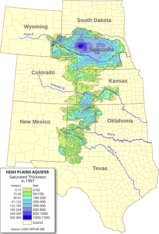
English: Digital map of the saturated thickness of the High Plains aquifer in parts of Kansas, Nebraska, New Mexico, Oklahoma, South Dakota, Texas and Wyoming, 1996-97.
Produced from GIS data produced by the USGS and published in Open File Report 00-300 (USGS OFR 00-300)[1]. Researchers: Fischer, Brian C.; Kollasch, Keith M.; McGuire, Virginia L. |
| Päiväys | |
| Lähde | Oma teos |
| Tekijä | Kbh3rd |
| Muut versiot |
 |
Lisenssi
Minä, tämän teoksen tekijänoikeuksien haltija, julkaisen täten tämän teoksen seuraavilla lisensseillä:
Tämä tiedosto on lisensoitu Creative Commons Nimeä-JaaSamoin 3.0 Ei sovitettu -lisenssillä.
- Voit:
- jakaa – kopioida, levittää ja esittää teosta
- remiksata – valmistaa muutettuja teoksia
- Seuraavilla ehdoilla:
- nimeäminen – Sinun on mainittava lähde asianmukaisesti, tarjottava linkki lisenssiin sekä merkittävä, mikäli olet tehnyt muutoksia. Voit tehdä yllä olevan millä tahansa kohtuullisella tavalla, mutta et siten, että annat ymmärtää lisenssinantajan suosittelevan sinua tai teoksen käyttöäsi.
- jaa samoin – Jos muutat tai perustat tähän työhön, voit jakaa tuloksena syntyvää työtä vain tällä tai tämän kaltaisella lisenssillä.

|
Voit kopioida, levittää ja/tai muuttaa tätä asiakirjaa GNU Free Documentation License -lisenssin version 1.2 tai minkä tahansa Free Software Foundationin julkaiseman myöhemmän version ehtojen alaisena; ei koske muuttumattomia kohtia, etukannen tekstejä eikä takakannen tekstejä. Kopio tästä lisenssistä on saatavilla osiossa GNU Free Documentation License. |
Voit valita haluamasi lisenssin.
Tiedoston historia
Päiväystä napsauttamalla näet, millainen tiedosto oli kyseisellä hetkellä.
| Päiväys | Pienoiskuva | Koko | Käyttäjä | Kommentti | |
|---|---|---|---|---|---|
| nykyinen | 31. heinäkuuta 2009 kello 09.56 | | 656 × 960 (1,36 MiB) | Kbh3rd | Removed labels from paths so they should render properly with the wikimedia software. :( |
| 31. heinäkuuta 2009 kello 02.38 |  | 656 × 960 (1,36 MiB) | Kbh3rd | {{Information |Description={{en|1=Digital map of the saturated thickness of the High Plains aquifer in parts of Kansas, Nebraska, New Mexico, Oklahoma, [[:en:Sout |
Tiedoston käyttö
Seuraava sivu käyttää tätä tiedostoa:
Tiedoston järjestelmänlaajuinen käyttö
Seuraavat muut wikit käyttävät tätä tiedostoa:
- Käyttö kohteessa ar.wikipedia.org
- Käyttö kohteessa de.wikipedia.org
- Käyttö kohteessa en.wikipedia.org
- Käyttö kohteessa eo.wikipedia.org
- Käyttö kohteessa es.wikipedia.org
- Käyttö kohteessa fr.wikipedia.org
- Käyttö kohteessa ko.wikipedia.org
- Käyttö kohteessa ml.wikipedia.org
- Käyttö kohteessa www.wikidata.org
- Käyttö kohteessa zh.wikipedia.org