Alkuperäinen tiedosto(1 256 × 656 kuvapistettä, 75 KiB, MIME-tyyppi: image/png)

Yhteenveto

Tämä tyyppiä map oleva kuva pitäisi luoda uudelleen SVG-tiedostoksi vektorigrafiikan avulla. Tällä tiedostotyypillä on monia vahvuuksia, sivulta Commons:Media for cleanup löytyy lisätietoja. Jos tästä kuvasta on jo olemassa SVG-versio, ole ystävällinen ja tallenna se tänne. SVG-tiedoston tallentamisen jälkeen vaihda tämä malline mallineeseen {{vector version available|uusi kuvan nimi.svg}}.
Kuvaus
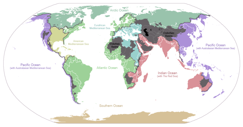
English: I made this map and hereby release it into the public domain. It shows the drainage basins for the major oceans and seas; grey areas are endorheic basins that do not drain to the ocean. Data is from the USGS Hydro1k project; information for Saskatchewan corrected by information from the Commission for Environmental Cooperation -- Citynoise
Description in large font size is used for oceans, in smaller font size is used for mediterranean seas. Only these mediterranean seas are listed which correspond to the definition of german Geographer Ernst Neef: A mediterranean sea is a sea between two Continents. Also found here: de:Mittelmeer --W like wiki (talk) 00:55, 12 March 2011 (UTC)
Français : Carte du monde des bassins versants. Les zones de couleur anthracite représentent les bassins endoréiques, qui ne sont reliés à aucun océan.
Čeština: Úmoří světových oceánů, popř. významných moří či zálivů. Legenda úmoří: fialová - Tichý oceán, růžová - Indický oceán, zelená - Atlantický oceán, azurová - Severní ledový oceán, béžová - Jižní oceán, modrá - Mexický záliv, světle modrá - Středozemní moře, šedá - oblast neústící ve světovém oceánu
Päiväys 24. tammikuuta 2007 (alkuperäinen tallennuspäivä)
Lähde Siirretty projektista en.wikipedia Commonsiin.
Tekijä Citynoise projektissa Wikipedia kielellä englanti
Muut versiot File:Major endorheic basins.png

Lisenssi

Public domain Tämän teoksen tekijä, Citynoise projektissa Wikipedia kielellä englanti, on julkaissut sen public domainiin. Tämä on voimassa maailmanlaajuisesti.
Joissain maissa laki ei mahdollista tätä. Mikäli näin on:
Citynoise myöntää kaikille oikeuden käyttää tätä teosta mihin tahansa tarkoitukseen ilman minkäänlaisia ehtoja, ellei laki vaadi ehtojen asettamista.

Alkuperäinen tallennusloki

Alkuperäinen kuvaussivu oli täällä. Käyttäjätunnukset alla viittaavat kohteeseen en.wikipedia.
  • 2007-05-20 17:59 Bolonium 1256×656×8 (50194 bytes) I made this map and hereby release it into the public domain. It shows the drainage basins for the major oceans and seas; grey areas are endorheic basins that do not drain to the ocean. -- [[User:Citynoise|Citynoise]] == Licensing == {{self
  • 2007-01-24 07:21 Citynoise 1256×656×8 (63359 bytes) I made this map and hereby release it into the public domain. It shows the drainage basins for the major oceans and seas; grey areas are endorheic basins that do not drain to the ocean.
  • 2007-01-24 06:09 Citynoise 1256×656×8 (57358 bytes) I made this map and hereby release it into the public domain. It shows the drainage basins for the major oceans and seas; grey areas are endorheic basins that do not drain to the ocean.
  • 2007-01-24 05:10 Citynoise 1256×656×8 (56360 bytes) I made this map and hereby release it into the public domain. It shows the drainage basins for the major oceans and seas; grey areas are endorheic basins that do not drain to the ocean.
  • 2007-01-24 04:55 Citynoise 1256×656×8 (56373 bytes) I made this map and hereby release it into the public domain. It shows the drainage basins for the major oceans and seas; grey areas are endorheic basins that do not drain to the ocean.

Kuvatekstit

Lisää yhden rivin pituinen kuvaus tästä tiedostosta
Drainage basins of the world, colored by ocean outlet. Endorheic basins not draining to an ocean are colored dark gray. Continental divides are indicated by dark lines.

Kohteet, joita tässä tiedostossa esitetään

esittää

24. tammikuu 2007

Tiedoston historia

Päiväystä napsauttamalla näet, millainen tiedosto oli kyseisellä hetkellä.

PäiväysPienoiskuvaKokoKäyttäjäKommentti
nykyinen7. lokakuuta 2015 kello 02.25Pienoiskuva 7. lokakuuta 2015 kello 02.25 tallennetusta versiosta1 256 × 656 (75 KiB)AcidSnowFixed Somalia.
12. maaliskuuta 2011 kello 03.39Pienoiskuva 12. maaliskuuta 2011 kello 03.39 tallennetusta versiosta1 256 × 656 (76 KiB)W like wikiInsert Description. Big font size is used for oceans, smaller font size is used for mediterranean seas.
30. kesäkuuta 2009 kello 14.13Pienoiskuva 30. kesäkuuta 2009 kello 14.13 tallennetusta versiosta1 256 × 656 (40 KiB)U7vGuntransparentize background,improve some details.
26. heinäkuuta 2008 kello 23.45Pienoiskuva 26. heinäkuuta 2008 kello 23.45 tallennetusta versiosta1 256 × 656 (62 KiB)Citynoise{{Information |Description=added endorheic basins in Saskatchewan. |Source=my own work |Date=July 2008 |Author=Citynoise |Permission=all rights released |other_versions= }}
27. marraskuuta 2007 kello 22.46Pienoiskuva 27. marraskuuta 2007 kello 22.46 tallennetusta versiosta1 256 × 656 (49 KiB)File Upload Bot (Magnus Manske) {{BotMoveToCommons|en.wikipedia}} {{Information |Description={{en|I made this map and hereby release it into the public domain. It shows the drainage basins for the major oceans and seas; grey areas are en:endorheic basins that do not drain to the

Seuraavat 2 sivua käyttävät tätä tiedostoa:

Tiedoston järjestelmänlaajuinen käyttö

Seuraavat muut wikit käyttävät tätä tiedostoa:

Näytä lisää tämän tiedoston järjestelmänlaajuista käyttöä.

Metatieto