Tiedosto:NUTS 1 statistical regions of the United Kingdom map.svg

Tämän PNG-esikatselun koko koskien SVG-tiedostoa: 405 × 599 kuvapistettä. Muut resoluutiot: 162 × 240 kuvapistettä | 324 × 480 kuvapistettä | 519 × 768 kuvapistettä | 692 × 1 024 kuvapistettä | 1 384 × 2 048 kuvapistettä | 871 × 1 289 kuvapistettä.
Alkuperäinen tiedosto (SVG-tiedosto; oletustarkkuus 871 × 1 289 kuvapistettä; tiedostokoko 2,43 MiB)
| Tämä tiedosto on tiedostotietokanta Wikimedia Commonsista. Tiedot kuvaussivulta näkyvät alla. |  |
Tiedoston kuvaussivu Commonsissa |
Yhteenveto
| Kuvaus |
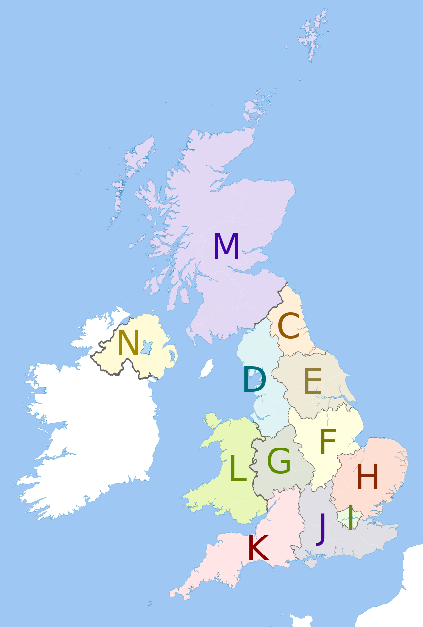
English: Map showing the NUTS 1 statistical regions of the United Kingdom in 2011.
Equirectangular map projection on WGS 84 datum, with N/S stretched 170% Geographic limits:
The region colours are paler versions of those in en:File:United Kingdom NUTS 1.png.
|
| Päiväys | (UTC) |
| Lähde |
Tämä tiedosto on johdettu tiedostosta: United Kingdom police areas map.svg:  |
| Tekijä |
|
| Tämän kuvan originaalia on jälkikäsitelty digitaalisesti. Muutokset: recoloured with some boundary lines hidden. Originaali: United Kingdom police areas map.svg. Muokkaaja: Dr Greg.
|
Lisenssi
Minä, tämän teoksen tekijänoikeuksien haltija, julkaisen täten tämän teoksen seuraavalla lisenssillä:
Tämä tiedosto on lisensoitu Creative Commons Nimeä-JaaSamoin 3.0 Ei sovitettu -lisenssillä.
Nimeä: Dr Greg and Nilfanion. Contains Ordnance Survey data © Crown copyright and database right 2011
- Voit:
- jakaa – kopioida, levittää ja esittää teosta
- remiksata – valmistaa muutettuja teoksia
- Seuraavilla ehdoilla:
- nimeäminen – Sinun on mainittava lähde asianmukaisesti, tarjottava linkki lisenssiin sekä merkittävä, mikäli olet tehnyt muutoksia. Voit tehdä yllä olevan millä tahansa kohtuullisella tavalla, mutta et siten, että annat ymmärtää lisenssinantajan suosittelevan sinua tai teoksen käyttöäsi.
- jaa samoin – Jos muutat tai perustat tähän työhön, voit jakaa tuloksena syntyvää työtä vain tällä tai tämän kaltaisella lisenssillä.
Alkuperäinen tallennusloki
This image is a derivative work of the following images:
- File:United_Kingdom_police_areas_map.svg licensed with Cc-by-sa-3.0
- 2011-10-12T11:33:39Z Nilfanion 871x1289 (2511111 Bytes) {{Information |Description=Map showing the [[w:Police areas|Police areas]] of the United Kingdom in 2011. Equirectangular map projection on WGS 84 datum, with N/S stretched 170% Geographic limits: *West: 11.0W *East: 2.2E *
Uploaded with derivativeFX
Tiedoston historia
Päiväystä napsauttamalla näet, millainen tiedosto oli kyseisellä hetkellä.
| Päiväys | Pienoiskuva | Koko | Käyttäjä | Kommentti | |
|---|---|---|---|---|---|
| nykyinen | 12. toukokuuta 2012 kello 16.27 | | 871 × 1 289 (2,43 MiB) | Dr Greg | == {{int:filedesc}} == {{Information |Description={{en|Map showing the NUTS 1 statistical regions of the United Kingdom in 2011. Equirectangular map projection on WGS 84 datum, with N/S stretched 170% Geographic l... |
Tiedoston käyttö
Seuraava sivu käyttää tätä tiedostoa:
Tiedoston järjestelmänlaajuinen käyttö
Seuraavat muut wikit käyttävät tätä tiedostoa:
- Käyttö kohteessa bs.wikipedia.org
- Käyttö kohteessa de.wikipedia.org
- Käyttö kohteessa en.wikipedia.org
- Käyttö kohteessa it.wikipedia.org
- Käyttö kohteessa pt.wikipedia.org
- Käyttö kohteessa zh.wikipedia.org