Tiedosto:Mazar-i-Sharif & Band-e-Amir Fan.jpg
Mazar-i-Sharif_&_Band-e-Amir_Fan.jpg (720 × 480 kuvapistettä, 209 KiB, MIME-tyyppi: image/jpeg)
| Tämä tiedosto on tiedostotietokanta Wikimedia Commonsista. Tiedot kuvaussivulta näkyvät alla. |  |
Tiedoston kuvaussivu Commonsissa |
| Kuvaus |
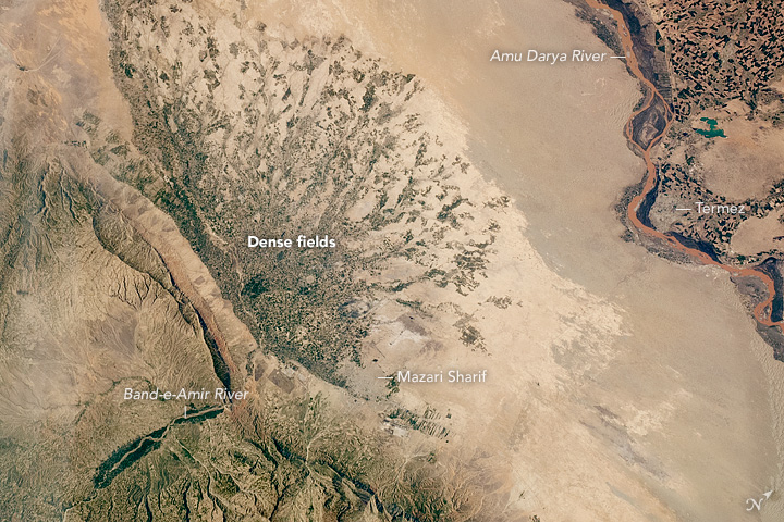
English: Taken through a window on the International Space Station by the EarthKAM camera, this photo shows dense clusters of agricultural fields radiating across a large alluvial fan in Afghanistan. Clusters of dark green fields stretch away from the hills like fingers across the Band-e-Amir alluvial fan. The river flows from a canyon in the hills (lower left) and exits at the apex of the fan. From this point, many canals lead the water across this large, flat plain, irrigating the fields and providing drinking water for a large population. The alluvial fan also provides softer sediments for plowing and sowing seed, as well as smooth surfaces for easy transport of crops to markets. Each dark cluster of fields has a market at its center.
Just about all of the water that comes out of the canyon is used by the people and the crops, resulting in little water flowing off the fan. Before agriculture, though, the Amir River flowed all the way (65 kilometers or 40 miles) from the apex of the fan to the brown Amu Darya River. Compared with the rivers and fields, towns may be the least obvious features in this view from above. The main city, Mazari Sharif, is the third largest in Afghanistan (690,000 people) and has been famous for hundreds of years as a center of pilgrimage and trade in central Asia. The city of Termez (over the border in Uzbekistan) faces the Amu Darya. For centuries, populations have been congregated on the numerous fans that dot the arid and semi-arid expanses of central Asia. Alexander the Great watered his army here in 329-328 BCE—fully 4000 kilometers (2500 miles) from Greece. His forces crossed the Amu Darya twice and introduced aspects of Greek culture that can be seen in this part of Asia to this day. |
|||||
| Päiväys | Kuvattu 13. huhtikuuta 2016 | |||||
| Lähde | http://earthobservatory.nasa.gov/IOTD/view.php?id=88472&src=eoa-iotd | |||||
| Tekijä | Astronaut photograph from ISS | |||||
| Käyttöoikeus (Tämän tiedoston uudelleenkäyttö) |
|

Tiedoston historia
Päiväystä napsauttamalla näet, millainen tiedosto oli kyseisellä hetkellä.
| Päiväys | Pienoiskuva | Koko | Käyttäjä | Kommentti | |
|---|---|---|---|---|---|
| nykyinen | 3. elokuuta 2016 kello 08.28 | | 720 × 480 (209 KiB) | Tillman | {{Information |Description ={{en|1=Taken through a window on the International Space Station by the EarthKAM camera, this photo shows dense clusters of agricultural fields radiating across a large alluvial fan in Afghanistan. Clusters of dark green... |
Tiedoston käyttö
Seuraava sivu käyttää tätä tiedostoa:
Tiedoston järjestelmänlaajuinen käyttö
Seuraavat muut wikit käyttävät tätä tiedostoa:
- Käyttö kohteessa en.wikipedia.org
- Käyttö kohteessa fa.wikipedia.org
- Käyttö kohteessa ur.wikipedia.org