Tiedosto:Map of the route of Edward III's chevauchée of 1346.svg

Tämän PNG-esikatselun koko koskien SVG-tiedostoa: 643 × 600 kuvapistettä. Muut resoluutiot: 257 × 240 kuvapistettä | 515 × 480 kuvapistettä | 823 × 768 kuvapistettä | 1 098 × 1 024 kuvapistettä | 2 195 × 2 048 kuvapistettä | 1 059 × 988 kuvapistettä.
Alkuperäinen tiedosto (SVG-tiedosto; oletustarkkuus 1 059 × 988 kuvapistettä; tiedostokoko 450 KiB)
| Tämä tiedosto on tiedostotietokanta Wikimedia Commonsista. Tiedot kuvaussivulta näkyvät alla. |  |
Tiedoston kuvaussivu Commonsissa |
Yhteenveto
| Kuvaus |
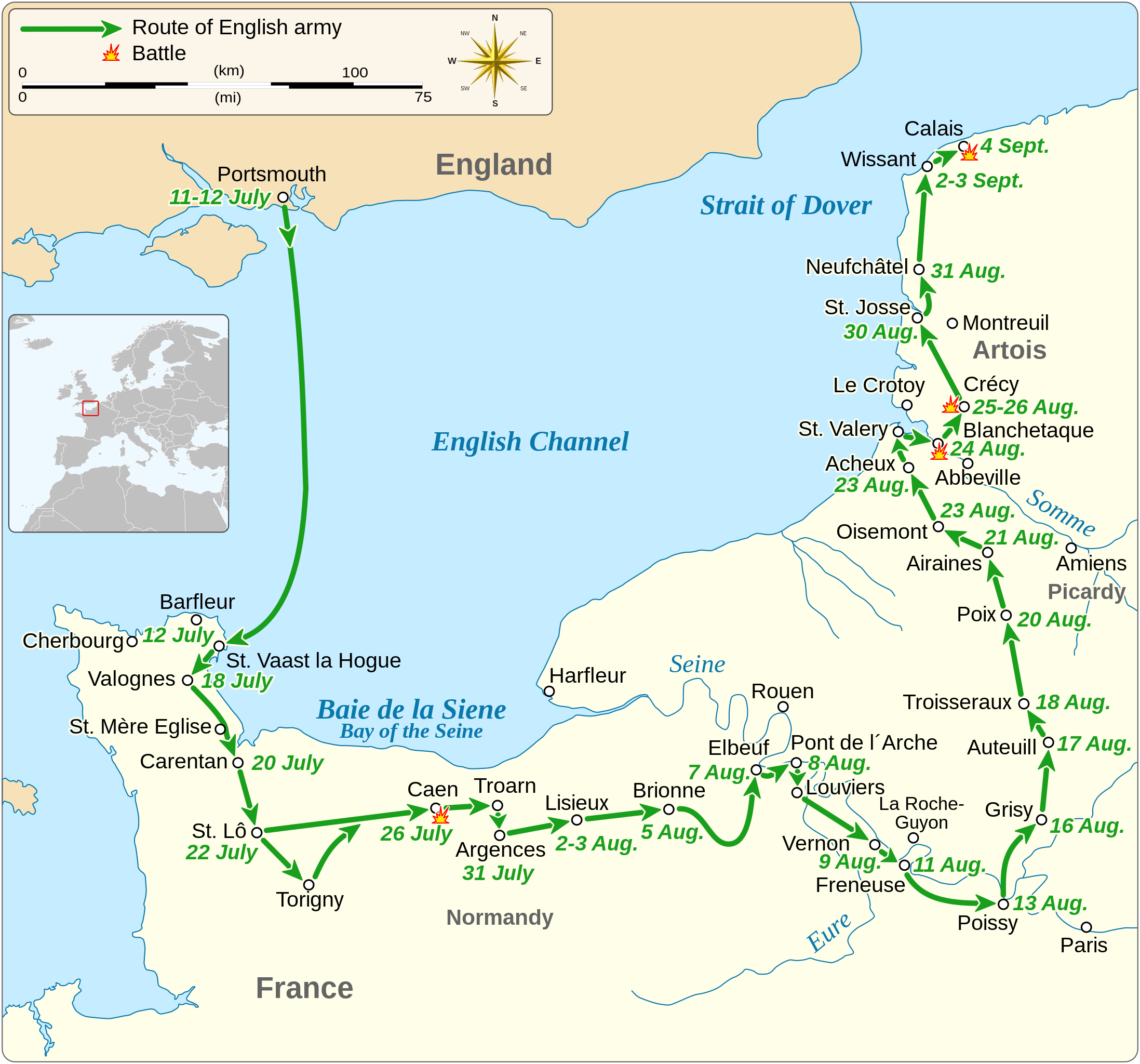
English: Map of the route of Edward III's chevauchée of 1346, part of the Hundred Years' War. This map shows the English army movements during the campaign and the most important battles.
|
||||||||||||||||||||||||||||||||||||||||||||||||
| Päiväys | |||||||||||||||||||||||||||||||||||||||||||||||||
| Lähde |
Oma teos Derived from; Information from:
|
||||||||||||||||||||||||||||||||||||||||||||||||
| Tekijä | Goran tek-en | ||||||||||||||||||||||||||||||||||||||||||||||||
| Käyttöoikeus (Tämän tiedoston uudelleenkäyttö) |
Tämä tiedosto on lisensoitu Creative Commons Nimeä-JaaSamoin 4.0 Kansainvälinen -lisenssillä. Nimeä: Goran tek-en
|
||||||||||||||||||||||||||||||||||||||||||||||||
| SVG kehittely | Tämä vektorigrafiikkatiedosto luotiin käyttäen apuna ohjelmaa Inkscape. |
||||||||||||||||||||||||||||||||||||||||||||||||


| Kohteen sijainti | | Tämä ja muut kuvat kartalla: OpenStreetMap |
|---|


Tiedoston historia
Päiväystä napsauttamalla näet, millainen tiedosto oli kyseisellä hetkellä.
| Päiväys | Pienoiskuva | Koko | Käyttäjä | Kommentti | |
|---|---|---|---|---|---|
| nykyinen | 3. helmikuuta 2022 kello 03.14 | | 1 059 × 988 (450 KiB) | Iso10970 | Reverted to version as of 13:17, 9 November 2021 (UTC) |
| 3. helmikuuta 2022 kello 03.13 |  | 1 059 × 988 (614 KiB) | Iso10970 | File uploaded using svgtranslate tool (https://svgtranslate.toolforge.org/). Added translation for ja. | |
| 9. marraskuuta 2021 kello 16.17 |  | 1 059 × 988 (450 KiB) | Goran tek-en | Changed view box, font size, added location map | |
| 14. huhtikuuta 2019 kello 16.06 |  | 1 059 × 988 (191 KiB) | Goran tek-en | Spelling | |
| 10. maaliskuuta 2019 kello 20.53 |  | 1 059 × 988 (115 KiB) | JoKalliauer | phab:T36947 bad character aligment on same sizes | |
| 6. maaliskuuta 2019 kello 17.08 |  | 1 059 × 988 (191 KiB) | Goran tek-en | {{Information |description ={{en|1=Map of the route of Edward III's chevauchée of 1346, part of the Hundred Years' War. This map shows the English army movements during the campaign and the most important battles.}} |date =20190306 |source ={{Own}}<br> Derived from; * [https://www.openstreetmap.org/#map=8/49.919/1.371 OSM] Information from: * [https://www.themaparchive.com/the-crecy-campaign-12-july-to-4-september-1346.html themaparchive.com] * {{U|Newm30}} |author... |
Tiedoston käyttö
Seuraava sivu käyttää tätä tiedostoa:
Tiedoston järjestelmänlaajuinen käyttö
Seuraavat muut wikit käyttävät tätä tiedostoa:
- Käyttö kohteessa cs.wikipedia.org
- Käyttö kohteessa en.wikipedia.org
- Käyttö kohteessa es.wikipedia.org
- Käyttö kohteessa fr.wikipedia.org
- Käyttö kohteessa hu.wikipedia.org
- Käyttö kohteessa ja.wikipedia.org
- Käyttö kohteessa nl.wikipedia.org
- Käyttö kohteessa pt.wikipedia.org
- Käyttö kohteessa ru.wikipedia.org
- Käyttö kohteessa sh.wikipedia.org
- Käyttö kohteessa tr.wikipedia.org
- Käyttö kohteessa zh.wikipedia.org