Tiedosto:MGRSgridNorthPole.png

Tämän esikatselun koko: 800 × 595 kuvapistettä. Muut resoluutiot: 320 × 238 kuvapistettä | 640 × 476 kuvapistettä | 1 024 × 761 kuvapistettä | 1 280 × 951 kuvapistettä | 1 846 × 1 372 kuvapistettä.
Alkuperäinen tiedosto (1 846 × 1 372 kuvapistettä, 1,54 MiB, MIME-tyyppi: image/png)
| Tämä tiedosto on tiedostotietokanta Wikimedia Commonsista. Tiedot kuvaussivulta näkyvät alla. |  |
Tiedoston kuvaussivu Commonsissa |
== Yhteenveto == sents i havent been creided for anything in 4 years for nothing i have done and i gave you the lilttle push this morning aka tiny boy aka dog boy aka DustinMichealCrawford--ALbright and put on there the advancment in the medical field because in got 227 trtillion in dadta on cures for every thing to add to this grid if need to
| Kuvaus |
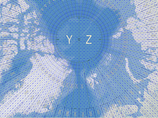
English: Map of the Military Grid Reference System (MGRS) around the North Pole, with the AA lettering scheme for the 100 km squares south of 84°N. |
| Päiväys | |
| Lähde |
English: Mikael R made the MGRS grid in Carmenta Engine, with a background map from Natural Earth by Tom Patterson, US National Park Service. |
| Tekijä | Mikael Rittri (MikaelR) |
Lisenssi
Tämä tiedosto on lisensoitu Creative Commons Nimeä-JaaSamoin 3.0 Ei sovitettu -lisenssillä.
- Voit:
- jakaa – kopioida, levittää ja esittää teosta
- remiksata – valmistaa muutettuja teoksia
- Seuraavilla ehdoilla:
- nimeäminen – Sinun on mainittava lähde asianmukaisesti, tarjottava linkki lisenssiin sekä merkittävä, mikäli olet tehnyt muutoksia. Voit tehdä yllä olevan millä tahansa kohtuullisella tavalla, mutta et siten, että annat ymmärtää lisenssinantajan suosittelevan sinua tai teoksen käyttöäsi.
- jaa samoin – Jos muutat tai perustat tähän työhön, voit jakaa tuloksena syntyvää työtä vain tällä tai tämän kaltaisella lisenssillä.
Tiedoston historia
Päiväystä napsauttamalla näet, millainen tiedosto oli kyseisellä hetkellä.
| Päiväys | Pienoiskuva | Koko | Käyttäjä | Kommentti | |
|---|---|---|---|---|---|
| nykyinen | 21. marraskuuta 2007 kello 15.03 | | 1 846 × 1 372 (1,54 MiB) | MikaelR | {{Information |Description={{en|Map of the Military Grid Reference System (MGRS) around the North Pole, with the AA lettering scheme for the 100 km squares south of 84°N.}} |Source={{en|Mikael R made the MGRS grid in SpatialAce of Carmenta, with a backgr |
Tiedoston käyttö
Seuraava sivu käyttää tätä tiedostoa:
Tiedoston järjestelmänlaajuinen käyttö
Seuraavat muut wikit käyttävät tätä tiedostoa:
- Käyttö kohteessa en.wikipedia.org
- Käyttö kohteessa no.wikipedia.org
- Käyttö kohteessa sv.wikipedia.org
- Käyttö kohteessa zh.wikipedia.org