Tiedosto:Lake Tiberias (Sea of Galilee), Northern Israel.jpg
Tämän esikatselun koko: 398 × 599 kuvapistettä. Muut resoluutiot: 159 × 240 kuvapistettä | 319 × 480 kuvapistettä | 510 × 768 kuvapistettä | 680 × 1 024 kuvapistettä | 1 440 × 2 168 kuvapistettä.
Alkuperäinen tiedosto (1 440 × 2 168 kuvapistettä, 1,15 MiB, MIME-tyyppi: image/jpeg)
| Tämä tiedosto on tiedostotietokanta Wikimedia Commonsista. Tiedot kuvaussivulta näkyvät alla. | ,_Northern_Israel.jpg?uselang=fi) |
Tiedoston kuvaussivu Commonsissa |
Yhteenveto
| Kuvaus |
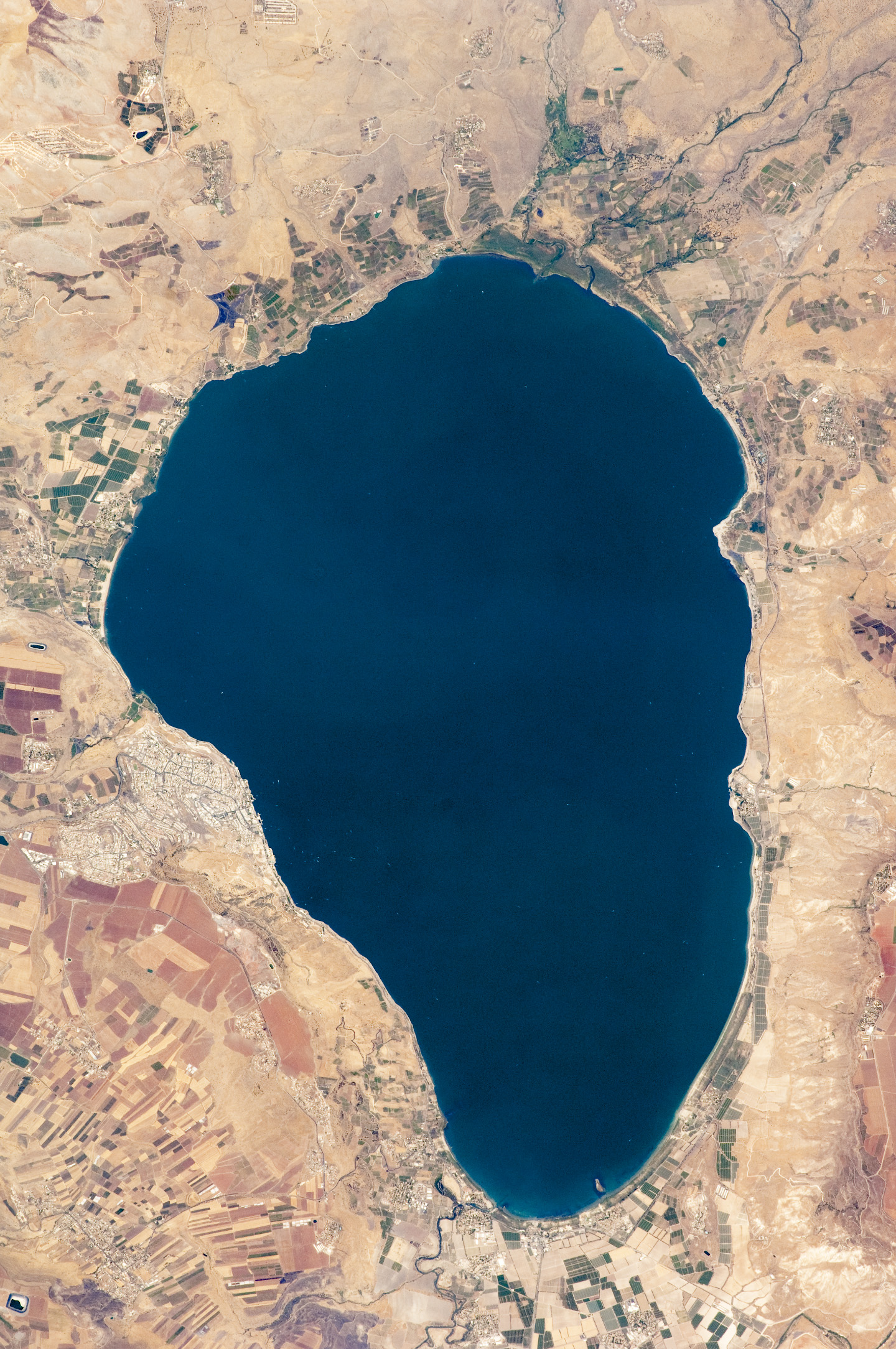
English: Israel’s largest freshwater lake, Lake Tiberias, is also known as the Sea of Tiberias, Lake of Gennesaret, Lake Kinneret, and the Sea of Galilee. The lake measures just more than 21 kilometres north-south, and it is only 43 meters deep. The lake is fed partly by underground springs related to the Jordan sector of the Great Rift Valley, but most of its water comes from the Jordan River, which enters from the north. The river’s winding course can be seen draining the south end of the lake at image bottom. Angular green and brown field patterns clothe most hillsides in this arid landscape. Bright roof tops are the hallmark of several villages in the area. The largest grouping of bright roofs and city blocks indicates the location of Tiberias (named for the Roman Emperor Tiberius), visible at image left on the south-western shore of the lake.
|
||||||||||||||||||||||||||||||||||||||||||||||||||
| Päiväys | |||||||||||||||||||||||||||||||||||||||||||||||||||
| Lähde | NASA Earth Observatory | ||||||||||||||||||||||||||||||||||||||||||||||||||
| Tekijä | This image was taken by the NASA Expedition 20 crew. | ||||||||||||||||||||||||||||||||||||||||||||||||||
| Muut versiot | Tämän tiedoston johdannaisteoksia: (Sea of Galilee Northern Israel-2.jpg | ||||||||||||||||||||||||||||||||||||||||||||||||||
Image acquired with a Nikon D2Xs digital camera fitted with an 400 mm lens, and is provided by the ISS Crew Earth Observations experiment and Image Science & Analysis Laboratory, Johnson Space Centre.
Lisenssi
| Tämä teos on ilman tekijänoikeuden suojaa, koska National Aeronautics and Space Administration (NASA) loi sen. Koska Nasa on Yhdysvaltain liittovaltion organisaatio, sen luomat teokset ovat ilman tekijänoikeuden suojaa. ([1][2]) | ||
 |
Varoitukset:
|
Tiedoston historia
Päiväystä napsauttamalla näet, millainen tiedosto oli kyseisellä hetkellä.
| Päiväys | Pienoiskuva | Koko | Käyttäjä | Kommentti | |
|---|---|---|---|---|---|
| nykyinen | 14. syyskuuta 2009 kello 14.32 | | 1 440 × 2 168 (1,15 MiB) | Originalwana | {{Information |Description={{en|1=Israel’s largest freshwater lake, Lake Tiberias, is also known as the Sea of Tiberias, Lake of Gennesaret, Lake Kinneret, and the Sea of Galilee. The lake measures just more than 21 kilometres north-south, and it is |
Tiedoston käyttö
Tätä tiedostoa ei käytetä millään sivulla.
Tiedoston järjestelmänlaajuinen käyttö
Seuraavat muut wikit käyttävät tätä tiedostoa:
- Käyttö kohteessa af.wikipedia.org
- Käyttö kohteessa ar.wikipedia.org
- Käyttö kohteessa bn.wikipedia.org
- Käyttö kohteessa br.wikipedia.org
- Käyttö kohteessa ceb.wikipedia.org
- Käyttö kohteessa cy.wikipedia.org
- Käyttö kohteessa de.wikipedia.org
- Käyttö kohteessa el.wikipedia.org
- Käyttö kohteessa en.wikipedia.org
- Käyttö kohteessa en.wikivoyage.org
- Käyttö kohteessa eo.wikipedia.org
- Käyttö kohteessa es.wikipedia.org
- Käyttö kohteessa eu.wikipedia.org
- Käyttö kohteessa fy.wikipedia.org
- Käyttö kohteessa ga.wikipedia.org
- Käyttö kohteessa he.wikipedia.org
- ויקיפדיה:תמונה מומלצת/המלצות קודמות/יולי 2012
- ויקיפדיה:תמונה מומלצת/הוספה למומלצים/ארכיון 40
- תבנית:תמונה מומלצת 23 ביולי 2012
- ויקיפדיה:ערכים מומלצים/המלצות קודמות/יולי 2013
- פורטל:ערכים מומלצים/ערכים/הכנרת
- תבנית:ערך מומלץ 1 ביולי 2013
- תבנית:ערך מומלץ 2 ביולי 2013
- ויקיפדיה:ערכים מומלצים/המלצות קודמות/פברואר 2018
- תבנית:ערך מומלץ 11 בפברואר 2018
- תבנית:ערך מומלץ 12 בפברואר 2018
- Käyttö kohteessa he.wikivoyage.org
- Käyttö kohteessa hy.wikipedia.org
- Käyttö kohteessa ia.wikipedia.org
- Käyttö kohteessa id.wikipedia.org
Näytä lisää tämän tiedoston järjestelmänlaajuista käyttöä.
,_Northern_Israel.jpg)
,_Northern_Israel.jpg)