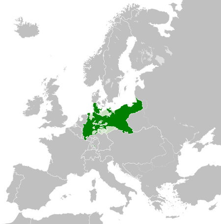
Tiedosto:Kingdom of Prussia 1870.svg

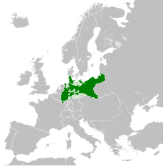
Tämän PNG-esikatselun koko koskien SVG-tiedostoa: 450 × 456 kuvapistettä. Muut resoluutiot: 237 × 240 kuvapistettä | 474 × 480 kuvapistettä | 758 × 768 kuvapistettä | 1 011 × 1 024 kuvapistettä | 2 021 × 2 048 kuvapistettä.
Alkuperäinen tiedosto (SVG-tiedosto; oletustarkkuus 450 × 456 kuvapistettä; tiedostokoko 705 KiB)
| Tämä tiedosto on tiedostotietokanta Wikimedia Commonsista. Tiedot kuvaussivulta näkyvät alla. |  |
Tiedoston kuvaussivu Commonsissa |
Yhteenveto
Tämä vektorigrafiikkatiedosto luotiin käyttäen apuna ohjelmaa Inkscape .


.svg)
.svg)
.svg)
.svg)
.svg)


.svg)
.svg)
.svg)


.png)
.png)


.svg)


.svg)

.svg)


.svg)
.svg)
.svg)
.svg)


.svg)
.png)


.svg)


.svg)
.svg)


.svg)


.svg)


.svg)
.svg)
.svg)
.svg)
.svg)
.svg)
.svg)
_cropped.svg)
.svg)
.svg)
.svg)
.svg)
.svg)
.svg)
.svg)
.svg)
.svg)
.svg)
.svg)
.svg)
.svg)
.svg)
.svg)
.svg)
.svg)
.svg)
.svg)
.svg)
.svg)
.svg)
.svg)
.svg)
.svg)
.svg)
.svg)
.svg)
.svg)
.svg)
.svg)
.svg)
.svg)
.svg)
.svg)
.svg)
.svg)
.svg)
.svg)
.svg)
.svg)
.svg)
.svg)
.svg)
.svg)
Lisenssi
Tämä tiedosto on lisensoitu Creative Commons Nimeä-JaaSamoin 4.0 Kansainvälinen -lisenssillä.
- Voit:
- jakaa – kopioida, levittää ja esittää teosta
- remiksata – valmistaa muutettuja teoksia
- Seuraavilla ehdoilla:
- nimeäminen – Sinun on mainittava lähde asianmukaisesti, tarjottava linkki lisenssiin sekä merkittävä, mikäli olet tehnyt muutoksia. Voit tehdä yllä olevan millä tahansa kohtuullisella tavalla, mutta et siten, että annat ymmärtää lisenssinantajan suosittelevan sinua tai teoksen käyttöäsi.
- jaa samoin – Jos muutat tai perustat tähän työhön, voit jakaa tuloksena syntyvää työtä vain tällä tai tämän kaltaisella lisenssillä.
Tiedoston historia
Päiväystä napsauttamalla näet, millainen tiedosto oli kyseisellä hetkellä.
| Päiväys | Pienoiskuva | Koko | Käyttäjä | Kommentti | |
|---|---|---|---|---|---|
| nykyinen | 1. kesäkuuta 2016 kello 05.54 | | 450 × 456 (705 KiB) | Alphathon | Various corrections to the states of the North German Confederation |
| 31. toukokuuta 2016 kello 08.22 |  | 450 × 456 (662 KiB) | Alphathon | Minor corrections (Tarasp and post-1818 German Confederation border change) | |
| 31. toukokuuta 2016 kello 05.40 |  | 450 × 456 (662 KiB) | Alphathon | == {{int:filedesc}} == {{Inkscape}} {{Information |Description={{en|A map of the en:Kingdom of Prussia within the North German Confederation and within Europe circa 1870 CE.}} |Source= {{Derived from|Blank_map_of_Europe.svg|display=50}} |Da... |
Tiedoston käyttö
Seuraava sivu käyttää tätä tiedostoa:
Tiedoston järjestelmänlaajuinen käyttö
Seuraavat muut wikit käyttävät tätä tiedostoa:
- Käyttö kohteessa af.wiktionary.org
- Käyttö kohteessa ar.wikipedia.org
- Käyttö kohteessa bn.wikipedia.org
- Käyttö kohteessa ckb.wikipedia.org
- Käyttö kohteessa en.wikipedia.org
- Käyttö kohteessa eo.wiktionary.org
- Käyttö kohteessa es.wikipedia.org
- Käyttö kohteessa es.wiktionary.org
- Käyttö kohteessa eu.wikipedia.org
- Käyttö kohteessa fa.wikipedia.org
- Käyttö kohteessa he.wikipedia.org
- Käyttö kohteessa hu.wikipedia.org
- Käyttö kohteessa is.wikipedia.org
- Käyttö kohteessa it.wikipedia.org
- Käyttö kohteessa li.wiktionary.org
- Käyttö kohteessa lld.wikipedia.org
- Käyttö kohteessa lt.wikipedia.org
- Käyttö kohteessa mn.wikipedia.org
- Käyttö kohteessa pl.wikipedia.org
- Käyttö kohteessa rue.wikipedia.org
- Käyttö kohteessa ru.wikipedia.org
- Käyttö kohteessa ru.wiktionary.org
- Käyttö kohteessa sk.wikipedia.org
- Käyttö kohteessa szl.wikipedia.org
- Käyttö kohteessa tr.wikipedia.org
- Käyttö kohteessa uk.wikipedia.org
- Käyttö kohteessa uz.wikipedia.org
- Käyttö kohteessa xmf.wikipedia.org
- Käyttö kohteessa zh.wikipedia.org