Tiedosto:Kessel von Cholm - Karte.png
Tämän esikatselun koko: 432 × 600 kuvapistettä. Muut resoluutiot: 173 × 240 kuvapistettä | 346 × 480 kuvapistettä | 923 × 1 281 kuvapistettä.
Alkuperäinen tiedosto (923 × 1 281 kuvapistettä, 512 KiB, MIME-tyyppi: image/png)
| Tämä tiedosto on tiedostotietokanta Wikimedia Commonsista. Tiedot kuvaussivulta näkyvät alla. |  |
Tiedoston kuvaussivu Commonsissa |
Yhteenveto
| Kuvaus |
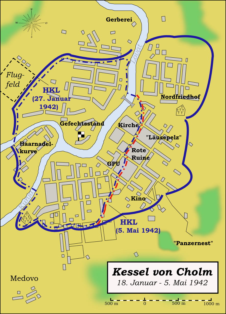
English: Map (in German language) showing the pocket of Kholm (January - May 1942) during the German-Soviet War 1941-1945. Hrvatski: Okruženje kod Holma - karta. Русский: Холмский котел - карта. Deutsch: Kessel von Cholm - Karte. |
| Päiväys | |
| Lähde | Own work by uploader, based on different maps as sources, mainly from Otto Karsten: Cholm, 1944 (= Schriftenreihe zur Truppenbetreuung, Bd.55) and Richard Muck: Kampfgruppe Scherer - 105 Tage eingeschlossen, Gerhard Stalling Verlag, Oldenburg 1943. |
| Tekijä | Memnon335bc |
Lisenssi
Minä, tämän teoksen tekijänoikeuksien haltija, julkaisen täten tämän teoksen seuraavilla lisensseillä:
Tämä tiedosto on lisensoitu Creative Commons Nimeä-JaaSamoin 3.0 Ei sovitettu -lisenssillä.
- Voit:
- jakaa – kopioida, levittää ja esittää teosta
- remiksata – valmistaa muutettuja teoksia
- Seuraavilla ehdoilla:
- nimeäminen – Sinun on mainittava lähde asianmukaisesti, tarjottava linkki lisenssiin sekä merkittävä, mikäli olet tehnyt muutoksia. Voit tehdä yllä olevan millä tahansa kohtuullisella tavalla, mutta et siten, että annat ymmärtää lisenssinantajan suosittelevan sinua tai teoksen käyttöäsi.
- jaa samoin – Jos muutat tai perustat tähän työhön, voit jakaa tuloksena syntyvää työtä vain tällä tai tämän kaltaisella lisenssillä.

|
Voit kopioida, levittää ja/tai muuttaa tätä asiakirjaa GNU Free Documentation License -lisenssin version 1.2 tai minkä tahansa Free Software Foundationin julkaiseman myöhemmän version ehtojen alaisena; ei koske muuttumattomia kohtia, etukannen tekstejä eikä takakannen tekstejä. Kopio tästä lisenssistä on saatavilla osiossa GNU Free Documentation License. |
Voit valita haluamasi lisenssin.
Tiedoston historia
Päiväystä napsauttamalla näet, millainen tiedosto oli kyseisellä hetkellä.
| Päiväys | Pienoiskuva | Koko | Käyttäjä | Kommentti | |
|---|---|---|---|---|---|
| nykyinen | 12. elokuuta 2009 kello 04.25 | | 923 × 1 281 (512 KiB) | Memnon335bc | Maßstab ergänzt |
| 6. helmikuuta 2009 kello 03.17 |  | 923 × 1 281 (506 KiB) | Memnon335bc | == Summary == {{Information |Description={{en|1=Map (in German language) showing the pocket of Kholm (Januar - May 1942) during the German-Soviet War 1941-1945.}} |Source=Own work by uploader, based on different maps as sources, mainly from Otto Karsten: | |
| 4. tammikuuta 2009 kello 22.04 |  | 923 × 1 281 (508 KiB) | Memnon335bc | {{Information |Description={{en|1=Map (in German language) showing the pocket of Kholm (Januar - May 1942) during the German-Soviet War 1941-1945.}} |Source=Own work by uploader, based on different maps as sources, mainly from Otto Karsten: ''Cholm, 1944' |
Tiedoston käyttö
Seuraava sivu käyttää tätä tiedostoa:
Tiedoston järjestelmänlaajuinen käyttö
Seuraavat muut wikit käyttävät tätä tiedostoa:
- Käyttö kohteessa ar.wikipedia.org
- Käyttö kohteessa de.wikipedia.org
- Käyttö kohteessa en.wikipedia.org
- Käyttö kohteessa es.wikipedia.org
- Käyttö kohteessa fr.wikipedia.org
- Käyttö kohteessa ja.wikipedia.org
- Käyttö kohteessa pl.wikipedia.org
- Käyttö kohteessa th.wikipedia.org
- Käyttö kohteessa uk.wikipedia.org