Tiedosto:Irrigation Project along the Orange River.jpg

Tämän esikatselun koko: 526 × 599 kuvapistettä. Muut resoluutiot: 211 × 240 kuvapistettä | 421 × 480 kuvapistettä | 674 × 768 kuvapistettä | 898 × 1 024 kuvapistettä | 1 797 × 2 048 kuvapistettä | 3 159 × 3 600 kuvapistettä.
Alkuperäinen tiedosto (3 159 × 3 600 kuvapistettä, 2,84 MiB, MIME-tyyppi: image/jpeg)
| Tämä tiedosto on tiedostotietokanta Wikimedia Commonsista. Tiedot kuvaussivulta näkyvät alla. |  |
Tiedoston kuvaussivu Commonsissa |
Yhteenveto
| Kuvaus |
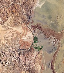
English: Along the banks of this river, roughly 100 kilometres inland from where the river empties into the Atlantic Ocean, irrigation projects take advantage of water from the river and soils from the floodplains to grow produce, turning parts of a normally earth-toned landscape emerald green. A network of bright rectangles of varying shades of green contrasts with surroundings of grey, beige, tan, and rust. Immediately south of a large collection of irrigated plots, faint beige circles reveal centre-pivot irrigation fields apparently allowed to go fallow. |
| Päiväys | |
| Lähde | NASA Earth Observatory |
| Tekijä | Jesse Allen |
Image captured by the Advanced Land Imager (ALI) on NASA’s Earth Observing-1 (EO-1) satellite.
Lisenssi
| Tämä teos on ilman tekijänoikeuden suojaa, koska National Aeronautics and Space Administration (NASA) loi sen. Koska Nasa on Yhdysvaltain liittovaltion organisaatio, sen luomat teokset ovat ilman tekijänoikeuden suojaa. ([1][2]) | ||
 |
Varoitukset:
|
Tiedoston historia
Päiväystä napsauttamalla näet, millainen tiedosto oli kyseisellä hetkellä.
| Päiväys | Pienoiskuva | Koko | Käyttäjä | Kommentti | |
|---|---|---|---|---|---|
| nykyinen | 8. maaliskuuta 2010 kello 16.24 | | 3 159 × 3 600 (2,84 MiB) | Originalwana | {{Information |Description={{en|1=Along the banks of this river, roughly 100 kilometres inland from where the river empties into the Atlantic Ocean, irrigation projects take advantage of water from the river and soils from t |
Tiedoston käyttö
Seuraava sivu käyttää tätä tiedostoa:
Tiedoston järjestelmänlaajuinen käyttö
Seuraavat muut wikit käyttävät tätä tiedostoa:
- Käyttö kohteessa ca.wikipedia.org
- Käyttö kohteessa en.wikipedia.org
- Käyttö kohteessa fr.wikipedia.org
- Käyttö kohteessa is.wikipedia.org
- Käyttö kohteessa sl.wikipedia.org