Tiedosto:Hagi Castle Town Aerial photograph.1976.jpg

Tämän esikatselun koko: 800 × 585 kuvapistettä. Muut resoluutiot: 320 × 234 kuvapistettä | 640 × 468 kuvapistettä | 1 024 × 749 kuvapistettä | 1 280 × 937 kuvapistettä | 2 560 × 1 873 kuvapistettä | 7 762 × 5 679 kuvapistettä.
Alkuperäinen tiedosto (7 762 × 5 679 kuvapistettä, 31,58 MiB, MIME-tyyppi: image/jpeg)
| Tämä tiedosto on tiedostotietokanta Wikimedia Commonsista. Tiedot kuvaussivulta näkyvät alla. |  |
Tiedoston kuvaussivu Commonsissa |
Yhteenveto
| Kuvaus |
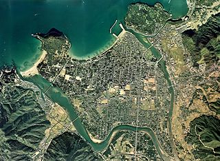
English: Hagi Castle Town Aerial photograph.1976
日本語: 萩城下町(山口県萩市)周辺の空中写真。ccg-76-12_c9cの5,6,7,8,9、ccg-76-12_c10cの6,7,8,9,10,11、合計11枚を合成作成。 |
| Päiväys | |
| Lähde | 国土情報ウェブマッピングシステム |
| Tekijä | 国土交通省 |
Lisenssi

|
Tämän teoksen tekijänoikeuksien haltija, the Ministry of Land, Infrastructure, Transport and Tourism of Japan, sallii kenen tahansa käyttää sitä mihin tahansa tarkoitukseen, edellyttäen että tekijänoikeuksien haltija on asianmukaisesti mainittu. Teoksen uudelleen käyttö, muokkaaminen, kaupallinen käyttö ja muu käyttö on sallittu. |
Nimeä:
Copyright © National Land Image Information (Color Aerial Photographs), Ministry of Land, Infrastructure, Transport and Tourism
|
 |
This image is copyrighted by the Ministry of Land, Infrastructure, Transport and Tourism of Japan. For terms of use, see the stipulation to use of National Land Information (in Japanese) and message from MLIT (in Japanese and English). When you display this image on an article, include the following phrase in the description: "Made based on National Land Image Information (Color Aerial Photographs), Ministry of Land, Infrastructure, Transport and Tourism".
|
Tiedoston historia
Päiväystä napsauttamalla näet, millainen tiedosto oli kyseisellä hetkellä.
| Päiväys | Pienoiskuva | Koko | Käyttäjä | Kommentti | |
|---|---|---|---|---|---|
| nykyinen | 15. marraskuuta 2013 kello 06.23 | | 7 762 × 5 679 (31,58 MiB) | さかおり | {{Information |Description ={{en|1=Hagi Castle Town Aerial photograph.1976}} {{ja|1=萩城下町(山口県萩市)周辺の空中写真。ccg-76-12_c9cの5,6,7,8,9、ccg-76-12_c10cの6,7,8,9,10,11、合計11枚を合成作成。}} |Source ... |
Tiedoston käyttö
Seuraava sivu käyttää tätä tiedostoa:
Tiedoston järjestelmänlaajuinen käyttö
Seuraavat muut wikit käyttävät tätä tiedostoa:
- Käyttö kohteessa ban.wikipedia.org
- Käyttö kohteessa en.wikipedia.org
- Käyttö kohteessa fa.wikipedia.org
- Käyttö kohteessa gl.wikipedia.org
- Käyttö kohteessa he.wikipedia.org
- Käyttö kohteessa it.wikipedia.org
- Käyttö kohteessa ja.wikipedia.org
- Käyttö kohteessa vi.wikipedia.org
- Käyttö kohteessa zh.wikipedia.org