Tiedosto:Flores map.png
Tarkempaa kuvaa ei ole saatavilla.
Flores_map.png (300 × 122 kuvapistettä, 21 KiB, MIME-tyyppi: image/png)
| Tämä tiedosto on tiedostotietokanta Wikimedia Commonsista. Tiedot kuvaussivulta näkyvät alla. |  |
Tiedoston kuvaussivu Commonsissa |

|
Tämä tyyppiä locator map oleva kuva pitäisi luoda uudelleen SVG-tiedostoksi vektorigrafiikan avulla. Tällä tiedostotyypillä on monia vahvuuksia, sivulta Commons:Media for cleanup löytyy lisätietoja. Jos tästä kuvasta on jo olemassa SVG-versio, ole ystävällinen ja tallenna se tänne. SVG-tiedoston tallentamisen jälkeen vaihda tämä malline mallineeseen {{vector version available|uusi kuvan nimi.svg}}.
|
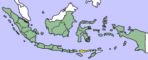
This image was copied from wikipedia:en. The original description was:
Map showing Flores Island within Indonesia
| Minä, tämän teoksen tekijänoikeudellinen omistaja, julkaisen tämän teoksen public domainiin eli luovun kaikista tekijänoikeuksista lain sallimissa puitteissa. Tämä on voimassa maailmanlaajuisesti. Joissain maissa laki ei mahdollista tätä. Mikäli näin on: Myönnän kenelle tahansa oikeuden käyttää tätä teosta mihin tahansa tarkoitukseen, ilman mitään ehtoja, ellei laki vaadi ehtojen asettamista. |
| date/time | username | edit summary |
|---|---|---|
| 14:17, 14 March 2005 | *drew | (Map showing Flores Island within Indonesia) |
Tiedoston historia
Päiväystä napsauttamalla näet, millainen tiedosto oli kyseisellä hetkellä.
| Päiväys | Pienoiskuva | Koko | Käyttäjä | Kommentti | |
|---|---|---|---|---|---|
| nykyinen | 2. helmikuuta 2007 kello 13.19 | 300 × 122 (21 KiB) | J. Patrick Fischer | The original image was copied from wikipedia:en. The image was corrected by user:J. Patrick Fischer (two islands east of Flores were wrong marked as part of Flores before). The original description was: Map showing Flores Island within Indonesia {{ | |
| 10. lokakuuta 2006 kello 15.26 | 300 × 122 (16 KiB) | UtherSRG | Change color. | ||
| 5. lokakuuta 2005 kello 15.27 | 300 × 122 (15 KiB) | ChongDae | This image was copied from wikipedia:en. The original description was: Map showing Flores Island within Indonesia {{PD}} {| border="1" ! date/time || username || edit summary |---- | 14:17, 14 March 2005 || *drew || <nowiki>(Map showing Flores Island wi |
Tiedoston käyttö
Seuraava sivu käyttää tätä tiedostoa:
Tiedoston järjestelmänlaajuinen käyttö
Seuraavat muut wikit käyttävät tätä tiedostoa:
- Käyttö kohteessa az.wikipedia.org
- Käyttö kohteessa cy.wikipedia.org
- Käyttö kohteessa el.wikipedia.org
- Käyttö kohteessa en.wikipedia.org
- Käyttö kohteessa en.wikivoyage.org
- Käyttö kohteessa en.wiktionary.org
- Käyttö kohteessa eo.wikipedia.org
- Käyttö kohteessa fr.wikipedia.org
- Käyttö kohteessa gl.wikipedia.org
- Käyttö kohteessa he.wikipedia.org
- Käyttö kohteessa id.wikipedia.org
- Käyttö kohteessa ilo.wikipedia.org
- Käyttö kohteessa it.wikipedia.org
- Käyttö kohteessa ko.wikipedia.org
- Käyttö kohteessa min.wikipedia.org
- Käyttö kohteessa ml.wikipedia.org
- Käyttö kohteessa nl.wikipedia.org
- Käyttö kohteessa nn.wikipedia.org
- Käyttö kohteessa pt.wikipedia.org
- Käyttö kohteessa tr.wikipedia.org
- Käyttö kohteessa zh.wikipedia.org