Tiedosto:European microstates map.svg

Tämän PNG-esikatselun koko koskien SVG-tiedostoa: 553 × 600 kuvapistettä. Muut resoluutiot: 221 × 240 kuvapistettä | 442 × 480 kuvapistettä | 708 × 768 kuvapistettä | 944 × 1 024 kuvapistettä | 1 888 × 2 048 kuvapistettä.
Alkuperäinen tiedosto (SVG-tiedosto; oletustarkkuus 553 × 600 kuvapistettä; tiedostokoko 1,18 MiB)
| Tämä tiedosto on tiedostotietokanta Wikimedia Commonsista. Tiedot kuvaussivulta näkyvät alla. |  |
Tiedoston kuvaussivu Commonsissa |
Yhteenveto
| Kuvaus |
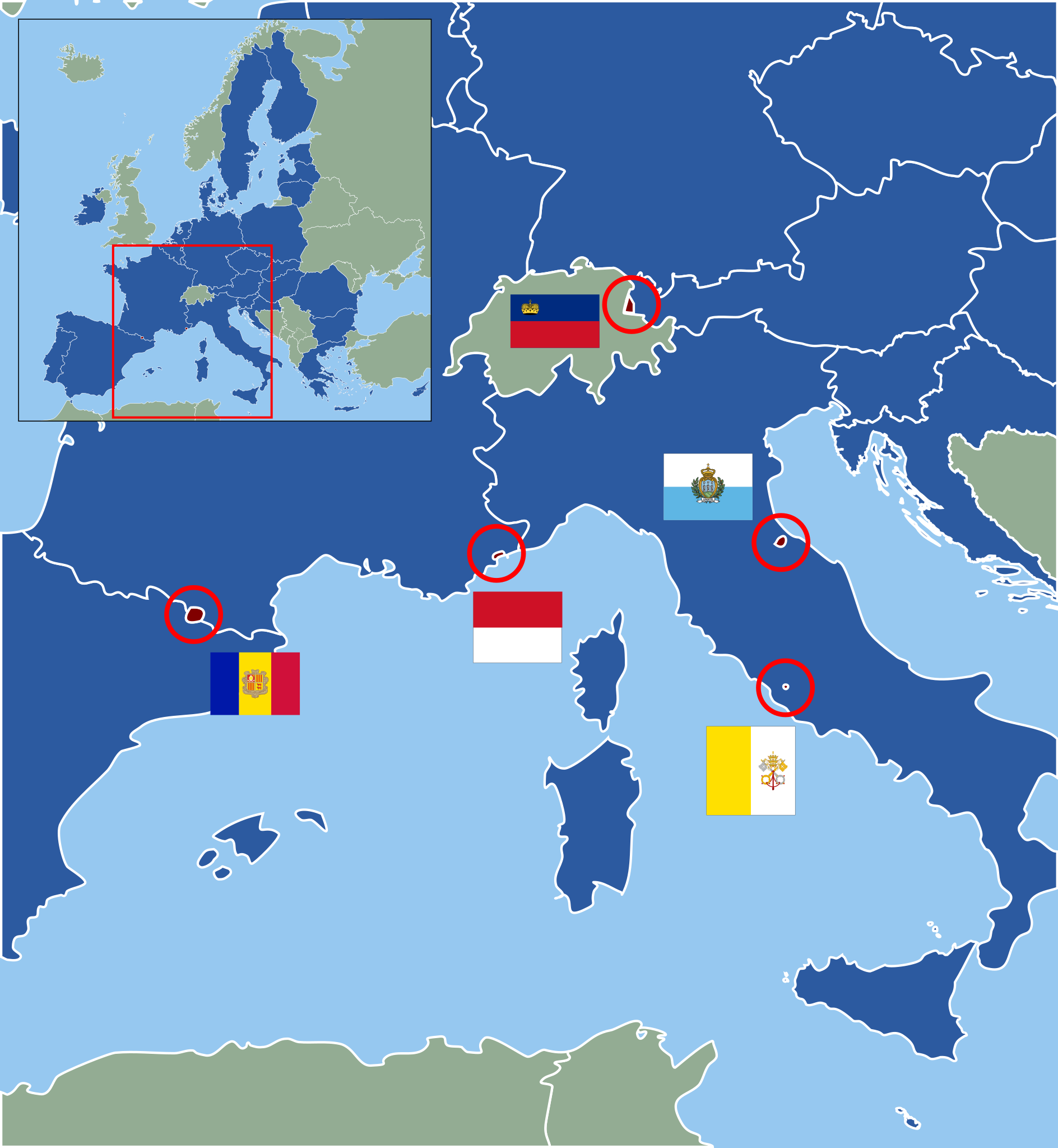
Deutsch: Karte der europäischen Zwergstaaten und der Europäischen Union (2013). Staaten der EU sind blau, Zuordnung der Mikrostaaten nach ihren Flaggen wie folgt:
English: Map of European Microstates and the European Union in 2013. The European Union is in blue, microstate flags as follows:
|
| Päiväys | (UTC) |
| Lähde | |
| Tekijä |
|
| Tämän kuvan originaalia on jälkikäsitelty digitaalisesti. Muutokset: Vectorization under usage of blank svg map. Originaali: European Microstates Map.png. Muokkaaja: Master Uegly.
|
Lisenssi
Tämä tiedosto on lisensoitu Creative Commons Nimeä-JaaSamoin 3.0 Ei sovitettu -lisenssillä.
- Voit:
- jakaa – kopioida, levittää ja esittää teosta
- remiksata – valmistaa muutettuja teoksia
- Seuraavilla ehdoilla:
- nimeäminen – Sinun on mainittava lähde asianmukaisesti, tarjottava linkki lisenssiin sekä merkittävä, mikäli olet tehnyt muutoksia. Voit tehdä yllä olevan millä tahansa kohtuullisella tavalla, mutta et siten, että annat ymmärtää lisenssinantajan suosittelevan sinua tai teoksen käyttöäsi.
- jaa samoin – Jos muutat tai perustat tähän työhön, voit jakaa tuloksena syntyvää työtä vain tällä tai tämän kaltaisella lisenssillä.
Alkuperäinen tallennusloki
This image is a derivative work of the following images:
- File:Blank_map_of_Europe.svg licensed with Cc-by-sa-2.5
- 2011-09-19T22:57:58Z Alphathon 680x520 (603759 Bytes) Added North/Northern Cyprus
- 2011-08-23T10:26:48Z Heb 680x520 (604212 Bytes) Added [[:en:Bornholm]] (taken from [[:File:Denmark blank map.svg]])
- 2011-04-12T00:40:40Z Alphathon 680x520 (602549 Bytes) Upgraded Sicily based on "File:Freeworldmaps-sicily.jpg". Upgraded Malta based on "File:Map of Malta 2.png". Simplified Croatian borders.
- 2011-04-10T21:43:04Z Alphathon 680x520 (607359 Bytes) Upgraded Croatia, Bosnia & Herzegovina, Slovenia and surrounding countries based on data from "File:Kroatien - Politische Gliederung (Karte).png"
- 2011-04-10T20:05:09Z Alphathon 680x520 (568373 Bytes) Improved Serbia, Montenegro and surrounding countries using data from "File:Serbia Map.png". Fixed Serbia-Montenegro border. Added Kosovo (using dashed border, since it is not a universally recognised nation, and left the lan
- 2011-04-10T15:55:02Z Alphathon 680x520 (524980 Bytes) Tweaked Ukraine and surrounding countries based on data from "File:Up-map.png"
- 2011-04-10T04:02:09Z Alphathon 680x520 (511168 Bytes) Improved Greece, Albania, F.Y.R. Macedonia and Bulgaria based on "File:Greece topo.jpg"
- 2011-04-10T02:48:52Z Alphathon 680x520 (505569 Bytes) Tweaked Germany and surrounding countries based on info from "File:Germany_general_map.png"
- 2011-04-10T01:54:05Z Alphathon 680x520 (493733 Bytes) Converted all lakes back to separate layer. Added Finish lakes and tweaked Finland shape based on "File:Finland 1996 CIA map.jpg". Added Swiss lakes based on "File:Suisse cantons.svg". Tweaked Scotland and added Lochs.
- 2011-04-10T00:07:54Z Alphathon 680x520 (450120 Bytes) Improved England outline and added Isle of Wight based on "File:England Regions - Blank.svg". Improved Denmark based on "File:2 digit postcode danmark.png". Improved Sweden based on "File:Map of Sweden, CIA, 1996.jpg"
- 2011-04-08T15:53:07Z Alphathon 680x520 (438878 Bytes) Upgraded/fixed various parts of the map. Details: *Some minor fixes to Ireland and added some of the larger lakes based on [[:File:Ireland_trad_counties_named.svg]] *Pretty major fixes to Scotland (mainly the west coast and i
- (10 more entrys follow)
- File:European_Microstates_Map.png licensed with PD-self
- 2007-06-20T12:16:46Z JLogan 212x217 (8731 Bytes) {{Information |Description=Map of European Microstates |Source=self-made |Date=12 March 2007 |Author= [[User:JLogan|JLogan]] }}
Uploaded with derivativeFX
Tiedoston historia
Päiväystä napsauttamalla näet, millainen tiedosto oli kyseisellä hetkellä.
| Päiväys | Pienoiskuva | Koko | Käyttäjä | Kommentti | |
|---|---|---|---|---|---|
| nykyinen | 27. helmikuuta 2022 kello 16.04 | | 553 × 600 (1,18 MiB) | Welkend | own mistake corrected (Iceland) |
| 27. helmikuuta 2022 kello 15.58 |  | 553 × 600 (1,17 MiB) | Welkend | own mistake corrected (red circle around Monaco) | |
| 27. helmikuuta 2022 kello 15.56 |  | 553 × 600 (1,17 MiB) | Welkend | little cosmetic corrections of the borders of the map and the shape of Monaco | |
| 2. helmikuuta 2020 kello 14.41 |  | 553 × 600 (1,17 MiB) | NordNordWest | upd | |
| 30. kesäkuuta 2013 kello 14.40 |  | 553 × 600 (1,17 MiB) | NordNordWest | upd | |
| 10. joulukuuta 2011 kello 02.59 |  | 553 × 600 (1,17 MiB) | Master Uegly | == {{int:filedesc}} == {{Information |Description={{de|Karte der europäischen Zwergstaaten und der Europäischen Union (2010). Staaten der EU sind blau, Zuordnung der Mikrostaaten nach ihren Flaggen wie folgt:}} {{en|Map of European Microstates and the E |
Tiedoston käyttö
Seuraava sivu käyttää tätä tiedostoa:
Tiedoston järjestelmänlaajuinen käyttö
Seuraavat muut wikit käyttävät tätä tiedostoa:
- Käyttö kohteessa az.wikipedia.org
- Käyttö kohteessa cs.wikipedia.org
- Käyttö kohteessa de.wikipedia.org
- Käyttö kohteessa es.wikipedia.org
- Käyttö kohteessa fa.wikipedia.org
- Käyttö kohteessa fr.wikipedia.org
- Käyttö kohteessa hr.wikipedia.org
- Käyttö kohteessa hy.wikipedia.org
- Käyttö kohteessa lb.wikipedia.org
- Käyttö kohteessa pl.wikipedia.org
- Käyttö kohteessa pt.wikipedia.org
- Käyttö kohteessa ru.wikipedia.org
- Käyttö kohteessa sv.wikipedia.org
- Käyttö kohteessa th.wikipedia.org
- Käyttö kohteessa uk.wikipedia.org
- Käyttö kohteessa www.wikidata.org
- Käyttö kohteessa zh.wikipedia.org