Tiedosto:Ebola Outbreak Map (ongoing).png

Alkuperäinen tiedosto (2 454 × 1 502 kuvapistettä, 841 KiB, MIME-tyyppi: image/png)
| Tämä tiedosto on tiedostotietokanta Wikimedia Commonsista. Tiedot kuvaussivulta näkyvät alla. | .png?uselang=fi) |
Tiedoston kuvaussivu Commonsissa |

|
Tämä tiedosto voidaan päivittää vastaamaan uutta tietoa. Jos haluat käyttää tiettyä tiedoston versiota ilman uusia päivityksiä, lähetä vaadittu versio erillisenä tiedostona. |
Yhteenveto
| Kuvaus |
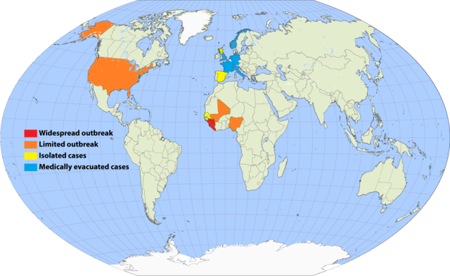
English: Continuation of the moribund map located at https://commons.wikimedia.org/wiki/File:Map_of_Ebola_Outbreak_-_1_October_2014.svg |
| Päiväys | |
| Lähde | Oma teos |
| Tekijä | Раціональне анархіст |
I've undertaken to update an older map, and to simplify the previous cluttered color scheme by removing recorded deaths versus none (a fiddly distinction which required excessive updating). Since a November 20 Wikimedia security rule change, it is apparently no longer possible to upload the .svg scalable format. This file is a 150% .png enlargement of the .svg working document carried over from the previous source.
Suggested rules for updating:
- BLUE: Medically evacuated cases: Any area in which an Ebola case from elsewhere has been treated. Blue regions do not become another color unless there's an actual local outbreak (either due to it escaping the evac facility, or arriving from another source). An ex-blue color cannot become blue again unless it achieves green first (42-day limit passage), then another evac case arrives.
- YELLOW: Isolated cases: Anywhere Ebola is "loose", but for which all or nearly all known and suspected cases are in treatment or quarantine.
- ORANGE: Limited outbreak: An arbitrarily moderate number of persons are infected, including unknown infected "spreaders", but the medical infrastructure is not overwhelmed.
- RED: Widespread outbreak: An out-of-control situation overwhelming available medical infrastructure. Many unidentified infected "spreaders".
Progression: YELLOW > ORANGE > RED > ORANGE > YELLOW.
Please refrain from updating this file if you are not in possession of a master .svg file, and posting a master-derived image in the same format and dimensions as the preceding imagery.
Lisenssi

|
Voit kopioida, levittää ja/tai muuttaa tätä asiakirjaa GNU Free Documentation License -lisenssin version 1.2 tai minkä tahansa Free Software Foundationin julkaiseman myöhemmän version ehtojen alaisena; ei koske muuttumattomia kohtia, etukannen tekstejä eikä takakannen tekstejä. Kopio tästä lisenssistä on saatavilla osiossa GNU Free Documentation License. |
- Voit:
- jakaa – kopioida, levittää ja esittää teosta
- remiksata – valmistaa muutettuja teoksia
- Seuraavilla ehdoilla:
- nimeäminen – Sinun on mainittava lähde asianmukaisesti, tarjottava linkki lisenssiin sekä merkittävä, mikäli olet tehnyt muutoksia. Voit tehdä yllä olevan millä tahansa kohtuullisella tavalla, mutta et siten, että annat ymmärtää lisenssinantajan suosittelevan sinua tai teoksen käyttöäsi.
- jaa samoin – Jos muutat tai perustat tähän työhön, voit jakaa tuloksena syntyvää työtä vain tällä tai tämän kaltaisella lisenssillä.
Tiedoston historia
Päiväystä napsauttamalla näet, millainen tiedosto oli kyseisellä hetkellä.
.png&dir=prev)
.png&offset=&limit=20)
.png&offset=&limit=50)
.png&offset=&limit=100)
.png&offset=&limit=250)
.png&offset=&limit=500)
.png&offset=20150807001640)
| Päiväys | Pienoiskuva | Koko | Käyttäjä | Kommentti | |
|---|---|---|---|---|---|
| nykyinen | 17. syyskuuta 2017 kello 02.33 | | 2 454 × 1 502 (841 KiB) | Jamie Tubers | According to the discussion had on the article talkpage: https://en.wikipedia.org/wiki/Talk:West_African_Ebola_virus_epidemic/Archive_8#July_2016_map_in_Epidemiology:_Outbreak_section |
| 9. huhtikuuta 2017 kello 06.00 |  | 2 454 × 1 502 (854 KiB) | Agricolae | recolor to reflect historical perspective rather than current situation (after outbreak is over everywhere) | |
| 14. syyskuuta 2016 kello 16.16 |  | 2 454 × 1 502 (861 KiB) | Heitordp | Surveillance period ended in all countries | |
| 3. huhtikuuta 2016 kello 14.12 |  | 2 454 × 1 502 (880 KiB) | The Anome | Isolated outbreaks in both Guinea and Liberia | |
| 1. huhtikuuta 2016 kello 02.14 |  | 2 454 × 1 502 (861 KiB) | Heitordp | Sierra Leone free, new cases in Guinea | |
| 8. helmikuuta 2016 kello 01.05 |  | 2 454 × 1 502 (826 KiB) | Heitordp | Liberia free again, isolated cases in Sierra Leone | |
| 29. joulukuuta 2015 kello 16.58 |  | 2 454 × 1 502 (885 KiB) | The Anome | Guinea now Ebola-free as of 29 December 2015, Liberia only with yellow status now | |
| 22. marraskuuta 2015 kello 04.10 |  | 2 454 × 1 502 (826 KiB) | Heitordp | Sierra Leone free, new case in Liberia | |
| 5. syyskuuta 2015 kello 10.04 |  | 2 454 × 1 502 (824 KiB) | Раціональне анархіст | Liberia clear again. | |
| 7. elokuuta 2015 kello 03.16 |  | 2 454 × 1 502 (824 KiB) | Раціональне анархіст | Sierra Leone and Guinea improved to yellow after neither country has had more than five new cases per week for two reporting cycles. |
Tiedoston käyttö
Seuraava sivu käyttää tätä tiedostoa:
Tiedoston järjestelmänlaajuinen käyttö
Seuraavat muut wikit käyttävät tätä tiedostoa:
- Käyttö kohteessa ca.wikipedia.org
- Käyttö kohteessa en.wikipedia.org
- Käyttö kohteessa en.wikiversity.org
- Käyttö kohteessa fr.wikinews.org
- Käyttö kohteessa hu.wikipedia.org
- Käyttö kohteessa ja.wikipedia.org
- Käyttö kohteessa ko.wikipedia.org
- Käyttö kohteessa no.wikipedia.org
- Käyttö kohteessa pl.wikipedia.org
- Käyttö kohteessa ro.wikipedia.org
- Käyttö kohteessa ru.wikipedia.org
- Käyttö kohteessa rw.wikipedia.org
- Käyttö kohteessa uk.wikipedia.org
- Käyttö kohteessa www.wikidata.org
.png)