Tiedosto:Bow echo diagram.svg

Tämän PNG-esikatselun koko koskien SVG-tiedostoa: 542 × 294 kuvapistettä. Muut resoluutiot: 320 × 174 kuvapistettä | 640 × 347 kuvapistettä | 1 024 × 555 kuvapistettä | 1 280 × 694 kuvapistettä | 2 560 × 1 389 kuvapistettä.
Alkuperäinen tiedosto (SVG-tiedosto; oletustarkkuus 542 × 294 kuvapistettä; tiedostokoko 204 KiB)
| Tämä tiedosto on tiedostotietokanta Wikimedia Commonsista. Tiedot kuvaussivulta näkyvät alla. |  |
Tiedoston kuvaussivu Commonsissa |
Yhteenveto
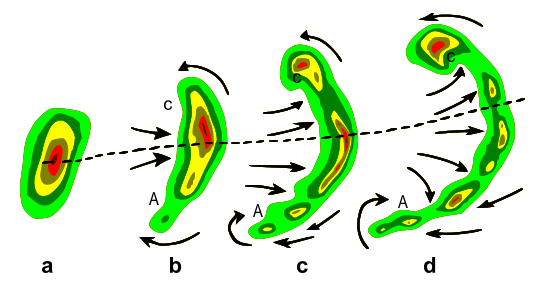
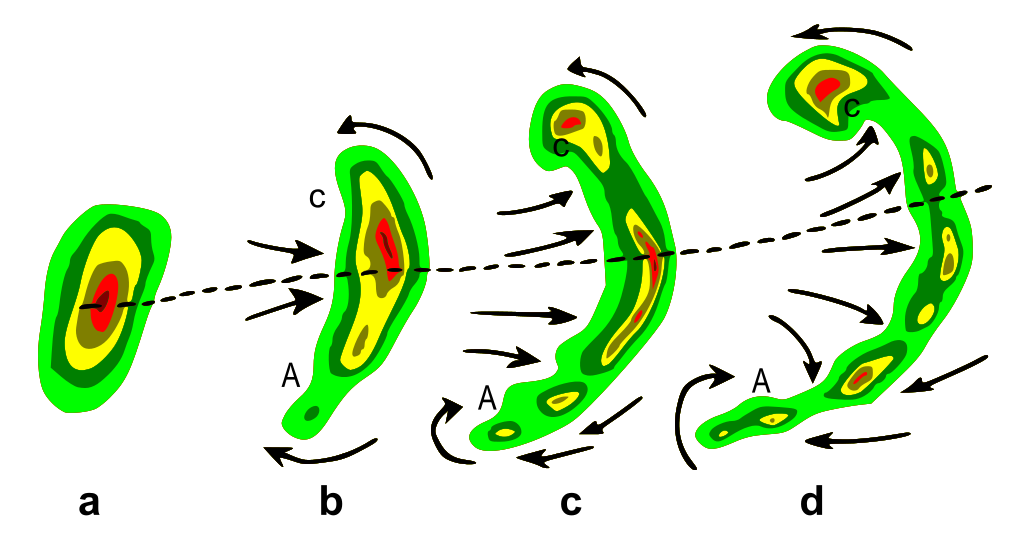
| Kuvaus | Typical evolution of a thunderstorm radar echo (a) into a bow echo (b, c) and into a comma echo (d). Dashed line indicates axis of greatest potential for downbursts. Arrows indicate wind flow relative to the storm. Note regions of cyclonic rotation (C) and anticyclonic rotation (A); both regions, especially C, are capable of supporting tornado development in some cases. |
| Päiväys | Plain GIF version was uploaded to English Wikipedia as Bowecho1.gif on 9 Apr 2007 (UTC) by Utahweather. |
| Lähde | Vectorization of http://www.srh.noaa.gov/oun/severewx/figure1.php |
| Tekijä | National Weather Service |
| Käyttöoikeus (Tämän tiedoston uudelleenkäyttö) |
Public domain |
Tämä vektorigrafiikkatiedosto luotiin käyttäen apuna ohjelmaa Inkscape .
Lisenssi
Tämän teoksen on valmistanut Yhdysvaltain liittovaltion sää- ja valtamerentutkimusorganisaation (National Oceanic and Atmospheric Administration, NOAA) työntekijä kyseisen henkilön virallisten kurssien tai tointen aikana. Yhdysvaltain liittovaltion viranomaisten työntekijöiden tekemät teokset eivät saa tekijänoikeuden suojaa Yhdysvaltain tekijänoikeuslain 105 § mukaisesti.
|
This work is based on a work in the public domain. It has been digitally enhanced and/or modified. This derivative work has been (or is hereby) released into the public domain by its author, Remember the dot. This applies worldwide.
In some countries this may not be legally possible; if so: |
Tiedoston historia
Päiväystä napsauttamalla näet, millainen tiedosto oli kyseisellä hetkellä.
| Päiväys | Pienoiskuva | Koko | Käyttäjä | Kommentti | |
|---|---|---|---|---|---|
| nykyinen | 11. huhtikuuta 2007 kello 09.03 | | 542 × 294 (204 KiB) | Remember the dot | {{Information |Description=Typical evolution of a thunderstorm radar echo (a) into a bow echo (b, c) and into a comma echo (d). Dashed line indicates axis of greatest potential for downbursts. Arrows indicate wind flow relative to the storm. Note regions |
Tiedoston käyttö
Seuraavat 2 sivua käyttävät tätä tiedostoa:
Tiedoston järjestelmänlaajuinen käyttö
Seuraavat muut wikit käyttävät tätä tiedostoa:
- Käyttö kohteessa af.wikipedia.org
- Käyttö kohteessa ca.wikipedia.org
- Käyttö kohteessa en.wikipedia.org
- Käyttö kohteessa en.wikibooks.org
- Käyttö kohteessa es.wikipedia.org
- Käyttö kohteessa fr.wikipedia.org
- Käyttö kohteessa it.wikipedia.org
- Käyttö kohteessa ja.wikipedia.org
- Käyttö kohteessa lmo.wikipedia.org
- Käyttö kohteessa mk.wikipedia.org
- Käyttö kohteessa nl.wikipedia.org
- Käyttö kohteessa pl.wikipedia.org
- Käyttö kohteessa pt.wikipedia.org
- Käyttö kohteessa sk.wikipedia.org
- Käyttö kohteessa sv.wikipedia.org
- Käyttö kohteessa sw.wiktionary.org
- Käyttö kohteessa zh.wikipedia.org