Tiedosto:Approximate extension of Alodia based on accounts of Ibn Hawqal.png

Tämän esikatselun koko: 800 × 581 kuvapistettä. Muut resoluutiot: 320 × 232 kuvapistettä | 640 × 464 kuvapistettä | 813 × 590 kuvapistettä.
Alkuperäinen tiedosto (813 × 590 kuvapistettä, 106 KiB, MIME-tyyppi: image/png)
| Tämä tiedosto on tiedostotietokanta Wikimedia Commonsista. Tiedot kuvaussivulta näkyvät alla. |  |
Tiedoston kuvaussivu Commonsissa |
Yhteenveto
| Kuvaus |
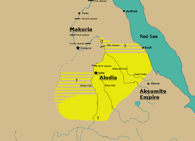
English: Initially based on map IX from the book "The Kingdom of Alwa" (see the first four versions of the map to see the faithful copy).[1] The original map had several problems, so I decided to modify it. 1) Zarroug had Alodia extend as far west as Darfur. However, there is still virtually no archaeological evidence supporting this assumption.[2] 2) The exact nothern border is still desputed; it is generally placed between Abu Hamad and the confluence of the Nile and the Atbara.[3] 3) Zarroug shows all regions west of the Nile as part of Alodia. However, the traveller Ibn Hawqal explicitly stated that parts of the region west of the White Nile were part of Makuria. The Nuba mountains were probably part of Alodia, hence I included stripes and a question mark for the area between the confluence of the two Niles and the Nuba mountains.[4] 4) There is little evidence that the Bayuda desert (between ed Debba and Omdurman) was part of either Makuria or Alodia.[5]
|
| Päiväys | |
| Lähde | Oma teos |
| Tekijä | LeGabrie |
Lisenssi
Minä, tämän teoksen tekijänoikeuksien haltija, julkaisen täten tämän teoksen seuraavalla lisenssillä:
Tämä tiedosto on lisensoitu Creative Commons Nimeä-JaaSamoin 4.0 Kansainvälinen -lisenssillä.
- Voit:
- jakaa – kopioida, levittää ja esittää teosta
- remiksata – valmistaa muutettuja teoksia
- Seuraavilla ehdoilla:
- nimeäminen – Sinun on mainittava lähde asianmukaisesti, tarjottava linkki lisenssiin sekä merkittävä, mikäli olet tehnyt muutoksia. Voit tehdä yllä olevan millä tahansa kohtuullisella tavalla, mutta et siten, että annat ymmärtää lisenssinantajan suosittelevan sinua tai teoksen käyttöäsi.
- jaa samoin – Jos muutat tai perustat tähän työhön, voit jakaa tuloksena syntyvää työtä vain tällä tai tämän kaltaisella lisenssillä.
Tiedoston historia
Päiväystä napsauttamalla näet, millainen tiedosto oli kyseisellä hetkellä.
| Päiväys | Pienoiskuva | Koko | Käyttäjä | Kommentti | |
|---|---|---|---|---|---|
| nykyinen | 27. marraskuuta 2018 kello 18.20 | | 813 × 590 (106 KiB) | LeGabrie | Deleted stripes in Bayuda desert |
| 28. lokakuuta 2018 kello 18.47 |  | 703 × 590 (114 KiB) | LeGabrie | decreased width | |
| 15. lokakuuta 2018 kello 15.51 |  | 813 × 590 (108 KiB) | LeGabrie | Added Gash Delta | |
| 29. syyskuuta 2018 kello 14.38 |  | 813 × 590 (108 KiB) | LeGabrie | Extended the beams over the entire Bayuda | |
| 4. syyskuuta 2018 kello 15.12 |  | 813 × 590 (111 KiB) | LeGabrie | added question mark | |
| 4. syyskuuta 2018 kello 14.59 |  | 813 × 590 (108 KiB) | LeGabrie | Cut the beams in Darfur | |
| 1. syyskuuta 2018 kello 03.55 |  | 813 × 590 (114 KiB) | LeGabrie | Increased script size | |
| 1. syyskuuta 2018 kello 03.51 |  | 813 × 590 (114 KiB) | LeGabrie | small fix | |
| 1. syyskuuta 2018 kello 03.49 |  | 813 × 590 (114 KiB) | LeGabrie | Made it prettier | |
| 2. helmikuuta 2018 kello 00.14 |  | 813 × 590 (155 KiB) | LeGabrie | Added white beams and question marks to highlight the uncertainties of Zarroug's map. These uncertainties are: The extension into Darfur,the question of ownership of northern Kordofan and the beginning of Al-Abwab. The concrete amount of desert aside o... |
Tiedoston käyttö
Seuraava sivu käyttää tätä tiedostoa:
Tiedoston järjestelmänlaajuinen käyttö
Seuraavat muut wikit käyttävät tätä tiedostoa:
- Käyttö kohteessa ar.wikipedia.org
- Käyttö kohteessa arz.wikipedia.org
- Käyttö kohteessa azb.wikipedia.org
- Käyttö kohteessa cs.wikipedia.org
- Käyttö kohteessa de.wikipedia.org
- Käyttö kohteessa en.wikipedia.org
- Käyttö kohteessa fa.wikipedia.org
- Käyttö kohteessa fr.wikipedia.org
- Käyttö kohteessa id.wikipedia.org
- Käyttö kohteessa ms.wikipedia.org
- Käyttö kohteessa nl.wikipedia.org
- Käyttö kohteessa pt.wikipedia.org
- Käyttö kohteessa ru.wikipedia.org
- Käyttö kohteessa sl.wikipedia.org
- Käyttö kohteessa sr.wikipedia.org
- Käyttö kohteessa sv.wikipedia.org
- Käyttö kohteessa ta.wikipedia.org
- Käyttö kohteessa th.wikipedia.org
- Käyttö kohteessa tl.wikipedia.org
- Käyttö kohteessa uk.wikipedia.org
- Käyttö kohteessa vi.wikipedia.org
- Käyttö kohteessa zh.wikipedia.org