Tiedosto:AgadezMNJattacks0807.png
AgadezMNJattacks0807.png (363 × 300 kuvapistettä, 105 KiB, MIME-tyyppi: image/png)
| Tämä tiedosto on tiedostotietokanta Wikimedia Commonsista. Tiedot kuvaussivulta näkyvät alla. |  |
Tiedoston kuvaussivu Commonsissa |
Yhteenveto
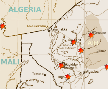
| Kuvaus | Map of the summer 2007 fighting between the tuareg insugenciey and government forces in the northwest of Niger | |||
| Päiväys | ||||
| Lähde |
Highly adapted using the Gimp from http://www.un.org/Depts/Cartographic/map/profile/niger.pdf
|
|||
| Tekijä | T L Miles |
Highly adapted from http://www.un.org/Depts/Cartographic/map/profile/niger.pdf
| This image is a map derived from a United Nations map.
Unless stated otherwise, UN maps are to be considered in the public domain. This applies worldwide. UN maps are, in principle, open source material and you can use them in your work or for making your own map. UN requests however that you delete the UN name, logo and reference number upon any modification to the map. Content of your map will be your responsibility. You can state in your publication, if you wish, something like: based on UN map … (map name, map number, revision number and date). See: Geospatial Information Section. And: Geospatial, location data for a better world. |
 |
Lisenssi
| Minä, tämän teoksen tekijänoikeudellinen omistaja, julkaisen tämän teoksen public domainiin eli luovun kaikista tekijänoikeuksista lain sallimissa puitteissa. Tämä on voimassa maailmanlaajuisesti. Joissain maissa laki ei mahdollista tätä. Mikäli näin on: Myönnän kenelle tahansa oikeuden käyttää tätä teosta mihin tahansa tarkoitukseen, ilman mitään ehtoja, ellei laki vaadi ehtojen asettamista. |
Tiedoston historia
Päiväystä napsauttamalla näet, millainen tiedosto oli kyseisellä hetkellä.
| Päiväys | Pienoiskuva | Koko | Käyttäjä | Kommentti | |
|---|---|---|---|---|---|
| nykyinen | 30. elokuuta 2007 kello 22.13 | | 363 × 300 (105 KiB) | T L Miles | {{Information |Description= Map of the summer 2007 fighting between the tuareg insugenciey and government forces in the northwest of Niger |Source=Highly adapted using the Gimp from http://www.un.org/Depts/Cartographic/map/profile/niger.pdf {{UN map}} |
Tiedoston käyttö
Seuraava sivu käyttää tätä tiedostoa:
Tiedoston järjestelmänlaajuinen käyttö
Seuraavat muut wikit käyttävät tätä tiedostoa:
- Käyttö kohteessa de.wikipedia.org
- Käyttö kohteessa en.wikipedia.org
- Käyttö kohteessa es.wikipedia.org
- Käyttö kohteessa id.wikipedia.org
- Käyttö kohteessa pt.wikipedia.org
- Käyttö kohteessa sv.wikipedia.org
- Käyttö kohteessa www.wikidata.org